
Lucky Peak Dam facts for kids
Quick facts for kids Lucky Peak Dam |
|
|---|---|

aerial view in June 1997
|
|


Location in southwest Idaho
|
|
| Country | United States |
| Location | Ada County, Idaho |
| Coordinates | 43°31′42″N 116°3′11″W / 43.52833°N 116.05306°W |
| Purpose | Flood control, irrigation |
| Construction began | 1949 |
| Opening date | 1955 |
| Construction cost | $19 million (1955) |
| Owner(s) | U.S. Army Corps of Engineers |
| Dam and spillways | |
| Type of dam | Embankment dam |
| Impounds | Boise River |
| Height | 340 ft (104 m) |
| Length | 2,340 ft (713 m) |
| Reservoir | |
| Creates | Lucky Peak Reservoir |
| Total capacity | 307,000 acre-feet (379,000,000 m3) |
| Catchment area | 2,680 square miles (6,940 km2) |
| Surface area | 2,820 acres (11.4 km2) |
| Normal elevation | 3,050 ft (930 m) |
| Power station | |
| Commission date | 1988 |
| Turbines | 2 x 45 MW, 1 x 11 MW Kaplan-type |
| Installed capacity | 101 MW |
| Annual generation | 321,790,000 KWh |
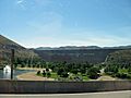
The Lucky Peak Dam is a large dam built from earth and gravel. It is located in Ada County, Idaho, in the western United States. This important dam sits on the Boise River, just downstream from another dam called Arrowrock Dam.
When it was built in the early 1950s, Lucky Peak Dam had two main jobs. Its first job was to control floods, which means stopping too much water from overflowing. Its second job was to help with irrigation, which is providing water for farms. The water level of the full reservoir is usually about 3,055 feet (931 m) above sea level.
Contents
Building the Lucky Peak Dam
Starting Construction
Work on Lucky Peak Dam began in November 1949. The U.S. Army Corps of Engineers was in charge of building it. This group is part of the U.S. Army and helps build big projects like dams.
Expert Help
Building the dam was a big challenge. Many workers were new to using dynamite, which is needed to blast through mountains. An expert named Clifford Riddle came to help. He was very skilled with dynamite. Clifford also helped design the curve of the road that leads to the reservoir today.
Who Built What?
Most other federal dams in southern Idaho were built by a different group called the Bureau of Reclamation. However, Lucky Peak Dam was built by the Corps of Engineers. Also, the Idaho Power Company, a private company, built many dams on the nearby Snake River.
Location and Features
Where is the Dam?
Lucky Peak Dam is located about ten miles (16 km) from the city of Boise. You can find it along State Highway 21.
How the Dam Got Its Name
The dam is named after a mountain called Lucky Peak, which is about four miles (6 km) north of the dam. This mountain is also known as Shaw Mountain. Its top is about 5,904 feet (1,800 m) high.
Lucky Peak Lake and Park
The dam creates a large body of water called Lucky Peak Lake. This lake is a popular spot for fun activities. The area around the dam and lake is part of Lucky Peak State Park, where people can enjoy nature.
Nearby Natural Wonder
Close to the dam, there's a special place called the Lucky Peak Dam Zeolite Occurrence. This is where unique minerals called zeolites can be found.
Generating Electricity
Adding Power Generation
When Lucky Peak Dam was first built, it did not produce electricity. However, that changed later on. Construction for a power plant began in 1984.
Powering Homes
The power plant started working in 1988. It generates electricity mainly for Seattle City Light, which is a company that provides power to homes and businesses in Seattle.
Images for kids
-
Lucky Peak Dam
-
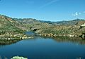
Lucky Peak Lake from Idaho highway 21
-
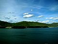
Lucky Peak Lake in April 2010


