
Boise greenbelt facts for kids


The Boise River Greenbelt is a super cool trail system that runs along the Boise River in Boise, Idaho, United States. Think of it like a long, green pathway that stretches for over 20 miles (32 km)! It starts way out east near Lucky Peak Dam and goes all the way past Eagle Road in Eagle, Idaho in the west. If you count both sides of the river and all the extra paths, the Greenbelt is actually more than 30 miles (48 km) long.
This awesome trail connects many of Boise's parks that are right by the river. It also links Boise with nearby towns. Most of the Greenbelt is paved, which means it's smooth for walking, running, or biking. However, some parts are unpaved, and you might not be allowed to ride bikes there. Don't worry, though! There are always other routes on nearby streets for bikes. Cars and other motorized vehicles are never allowed on the Greenbelt.
Contents
History of the Greenbelt
How the Idea Started
Back in 1962, the city of Boise hired some experts to help plan for the future. They suggested that Boise should buy land along the Boise River. The idea was to create a continuous "green belt" of public land. This would stretch all the way through the city.
Soon, local people started working together to clean up the river. They also wanted to make sure everyone could easily get to the river. This idea of a "green belt" really caught on! By 1967, three small pieces of land were given to the city. This was the start of the Greenbelt.
Building the Greenbelt
In 1968, more and more people were interested in the Greenbelt. So, the city adopted its first official Greenbelt Plan. A special committee was formed in 1969 to help guide the city. Their job was to develop the Greenbelt.
Then, in 1971, the city passed a rule called the Greenbelt Ordinance. This rule said that new buildings and parking lots had to be at least 70 feet (21 meters) away from the river. This helped protect the riverbanks. The city kept adding land to the Greenbelt bit by bit. They bought land, traded land, leased land, and even received donations from people and groups.
Cool Places Along the Greenbelt
The Boise River Greenbelt is packed with fun and interesting spots! Whether you're on the north side or the south side of the river, there's always something to see or do.
North Bank Highlights


As you travel from east to west on the north side, you'll find:
- Parks and Nature: You can visit places like Lucky Peak State Park, Marianne Williams Park, and the Kristin Armstrong Municipal Park. These are great for picnics or just enjoying nature.
- Fun Activities: The Idaho Shakespeare Festival is nearby, where you can watch plays. There's also the Warm Springs Golf Course if you like to golf.
- Downtown Attractions: When you get closer to downtown Boise, you'll pass by Julia Davis Park. This park is home to the Boise Zoo and several museums. You can also see a cool Solar System Model!
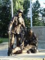
- Special Memorials: The Anne Frank Human Rights Memorial is a very important and peaceful place to visit. There's also a Fallen Firefighter Memorial.
- River Fun: Don't miss the Boise River Recreation Park, Whitewater Park! This is where people can kayak and surf on the river.
- More Parks: Further west, you'll find Veterans Memorial Park and Willow Lane Park.
Sometimes, the north bank trail might end or have a detour. For example, near Plantation Island, you can cross pedestrian bridges to the south bank. Also, in Garden City, there's a section where you can't ride bikes on the Greenbelt. But there are special bike routes on nearby streets to help you keep going!
South Bank Highlights


On the south side, also from east to west, you'll discover:
- Barber Park: A popular spot to start floating the river in the summer.
- Boise State University: The Greenbelt runs right by the university campus.
- Ann Morrison Park: A huge park with lots of open space and activities.
- Kathryn Albertson Park: A beautiful, quiet park with ponds and walking paths.
- Riverside Hotel: A landmark along the river.
- Expo Idaho: This is where the Western Idaho Fair is held every year.
- Garden City Library: A nice place to stop and relax.
Just like the north bank, there are a few spots on the south bank where bikes might be routed onto nearby streets. This happens in areas where the trail is unpaved or has a gap.
Greenbelt DOTS: Your Trail Guide

Have you ever wondered how far you've gone on the Greenbelt? Or where exactly you are? That's what the "DOTS" are for! DOTS stands for Distance & Orientation Trail System.
These are big, white circles, about 18 inches (45 cm) wide, painted right on the Greenbelt path. There are over 100 of them! They act like mile markers, helping you know your exact location.
The central point, or "mile 0," is near 8th Street and River Street in downtown Boise. The DOTS are placed every tenth of a mile (about 160 meters).
Here's how they work:
- If you see a DOT that says "NW 1.0," it means you are on the North bank, West of the central point, and 1.0 miles (1.6 km) away.
- If you see "SE 5.3," you are on the South bank, East of the central point, and 5.3 miles (8.5 km) away.
So, the next time you're on the Greenbelt, keep an eye out for these helpful DOTS!
Images for kids
-
Fallen Firefighter Memorial at NW 1.0

