Owyhee Desert facts for kids
Quick facts for kids Owyhee Desert |
|
|---|---|

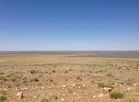
Much of the Owyhee Desert in Nevada is flat and fairly featureless
|
|
| Geography | |
| Country | United States |
| States | Nevada, Idaho and Oregon |
The Owyhee Desert is a huge, dry area in the Northwestern United States. It's part of a larger type of land called a desert and dry shrubland biome. A special road, the Owyhee Uplands Byway, goes right through this desert.
Contents
Exploring the Owyhee Desert's Landscape
The Owyhee Desert is a vast, dry place covering about 9,375 square miles. It's made up of deep canyons, interesting volcanic rocks, and lots of sagebrush and grass.
Where is the Owyhee Desert Located?
This desert stretches across parts of three states: northern Nevada, southwestern Idaho, and southeastern Oregon. You can find it on the southern edge of the Columbia Plateau, southwest of Boise, Idaho. It reaches east from the Santa Rosa Range mountains.
How High is the Owyhee Desert?
The Owyhee Desert sits quite high up, with an average elevation of about 5,300 feet (1,615 meters) above sea level.
Rivers and Waterways
Even though it's a desert, water still flows through it! The Owyhee Desert is mainly drained by smaller rivers that feed into the Bruneau River and the Owyhee River. These rivers then flow into the much larger Snake River.
Who Manages the Owyhee Desert?
Most of the land in the Owyhee Desert is owned by the United States government. It is managed by an agency called the Bureau of Land Management (BLM).
What is the Land Used For?
The Owyhee Desert is mostly used as land for ranching. This means that ranchers let their cattle graze there. In 1999, a group called the Desert Group suggested new ways to manage the resources in the Owyhee Desert.
 | Charles R. Drew |
 | Benjamin Banneker |
 | Jane C. Wright |
 | Roger Arliner Young |

