
Prineville, Oregon facts for kids
Quick facts for kids
Prineville, Oregon
|
|
|---|---|
 |
|
| Nickname(s):
The Key City of the High Desert, The Heart of Oregon, The Land of Nothing
|
|

Location in Oregon
|
|
| Country | United States |
| State | Oregon |
| County | Crook |
| Incorporated | 1880 |
| Area | |
| • Total | 12.83 sq mi (33.23 km2) |
| • Land | 12.83 sq mi (33.23 km2) |
| • Water | 0.00 sq mi (0.00 km2) |
| Elevation | 2,868 ft (874.2 m) |
| Population
(2020)
|
|
| • Total | 10,736 |
| • Density | 836.79/sq mi (323.07/km2) |
| Time zone | UTC−8 (Pacific) |
| • Summer (DST) | UTC−7 (Pacific) |
| ZIP code |
97754
|
| Area code(s) | 541 |
| FIPS code | 41-59850 |
| GNIS feature ID | 1154317 |
| Website | www.cityofprineville.com |
Prineville is a city in Oregon, United States. It is the main city, or seat, of Crook County. The city was named after Barney Prine. He was the first merchant to set up businesses in this area. In 2020, about 10,736 people lived in Prineville.
Contents
History of Prineville
Prineville was started in 1877. Monroe Hodges officially created the first map and plan for the city. The post office was first called Prine in 1871. It changed to Prineville in 1872. The city became an official city in 1880. Its first high school opened in 1902.
The City's Own Railroad
For a long time, Prineville was the biggest town in central Oregon. But in 1911, two powerful railroad builders, James J. Hill and Edward H. Harriman, decided to build their train tracks around Prineville. This was a big problem because having a railroad meant a town could grow and be successful. Without one, a town might become a ghost town, meaning it would be empty.
So, in 1917, the people of Prineville voted to build their own railway. The vote was almost unanimous, 355 to 1! They raised money to connect their town to the main railroad line, which was about 19 miles (31 km) away.
Railroad Success and Changes
The City of Prineville Railroad did very well for many years. This was thanks to the timber (wood) that came from the nearby Ochoco National Forest. The railroad made so much money that from 1964 to 1968, the city didn't have to collect any property taxes from its residents.
However, the timber industry in Oregon started to decline. This meant the railroad began to lose money. Between 2002 and 2004, it lost almost $1 million.
Modern Growth: Tech Companies
Since the late 2000s, big tech companies like Apple and Facebook have invested a lot of money in Prineville. They have built many large data centers in the city. Each company has spent over $1 billion on these projects.
Geography and Climate
Prineville covers about 10.92 square miles (28.28 square kilometers) of land. It is located on the Crooked River. It is also at the mouth of Ochoco Creek. This is about 14 miles (23 km) northwest of the Prineville Reservoir.
Unique Landforms
Millions of years ago, during the Miocene and Oligocene periods, huge flows of basalt rock covered the area. Barnes Butte is a famous hill formed by this ancient volcanic activity. Part of Barnes Butte is even inside the city limits.
Prineville's Climate
Prineville has a cool semiarid climate. This means it is usually dry, but not as hot as a desert.
The highest temperature ever recorded in Prineville was 119 °F (48.3 °C). This happened on July 29, 1898. Other cities in Oregon also recorded this same high temperature. The most recent time Oregon's highest temperature was recorded was on June 29, 2021, at Pelton Dam.
| Climate data for Prineville, Oregon (1991–2020 normals, extremes 1897–present) | |||||||||||||
|---|---|---|---|---|---|---|---|---|---|---|---|---|---|
| Month | Jan | Feb | Mar | Apr | May | Jun | Jul | Aug | Sep | Oct | Nov | Dec | Year |
| Record high °F (°C) | 76 (24) |
75 (24) |
83 (28) |
92 (33) |
99 (37) |
109 (43) |
119 (48) |
106 (41) |
107 (42) |
93 (34) |
82 (28) |
76 (24) |
119 (48) |
| Mean daily maximum °F (°C) | 43.2 (6.2) |
47.6 (8.7) |
54.7 (12.6) |
60.2 (15.7) |
68.9 (20.5) |
76.4 (24.7) |
86.9 (30.5) |
86.4 (30.2) |
79.0 (26.1) |
65.1 (18.4) |
51.3 (10.7) |
41.9 (5.5) |
63.5 (17.5) |
| Daily mean °F (°C) | 34.1 (1.2) |
37.0 (2.8) |
41.9 (5.5) |
46.7 (8.2) |
54.5 (12.5) |
60.5 (15.8) |
68.0 (20.0) |
67.1 (19.5) |
60.5 (15.8) |
49.7 (9.8) |
40.0 (4.4) |
32.9 (0.5) |
49.4 (9.7) |
| Mean daily minimum °F (°C) | 25.1 (−3.8) |
26.4 (−3.1) |
29.2 (−1.6) |
33.1 (0.6) |
40.0 (4.4) |
44.5 (6.9) |
49.1 (9.5) |
47.8 (8.8) |
41.9 (5.5) |
34.3 (1.3) |
28.6 (−1.9) |
23.9 (−4.5) |
35.3 (1.8) |
| Record low °F (°C) | −35 (−37) |
−24 (−31) |
−14 (−26) |
7 (−14) |
13 (−11) |
20 (−7) |
26 (−3) |
23 (−5) |
12 (−11) |
4 (−16) |
−15 (−26) |
−32 (−36) |
−35 (−37) |
| Average precipitation inches (mm) | 1.06 (27) |
0.80 (20) |
0.91 (23) |
0.76 (19) |
1.38 (35) |
0.85 (22) |
0.40 (10) |
0.36 (9.1) |
0.31 (7.9) |
0.95 (24) |
1.22 (31) |
1.33 (34) |
10.33 (262) |
| Average snowfall inches (cm) | 1.8 (4.6) |
3.2 (8.1) |
0.9 (2.3) |
0.3 (0.76) |
0.0 (0.0) |
0.0 (0.0) |
0.0 (0.0) |
0.0 (0.0) |
0.0 (0.0) |
0.0 (0.0) |
1.1 (2.8) |
1.5 (3.8) |
8.8 (22) |
| Average precipitation days (≥ 0.01 in) | 8.1 | 7.0 | 8.1 | 7.8 | 7.2 | 5.3 | 2.1 | 2.4 | 2.8 | 6.4 | 8.4 | 7.8 | 73.4 |
| Average snowy days (≥ 0.1 in) | 1.6 | 2.3 | 1.1 | 0.3 | 0.0 | 0.0 | 0.0 | 0.0 | 0.0 | 0.0 | 0.9 | 1.1 | 7.3 |
| Source: NOAA | |||||||||||||
Population of Prineville
| Historical population | |||
|---|---|---|---|
| Census | Pop. | %± | |
| 1890 | 460 | — | |
| 1900 | 656 | 42.6% | |
| 1910 | 1,042 | 58.8% | |
| 1920 | 1,144 | 9.8% | |
| 1930 | 1,027 | −10.2% | |
| 1940 | 2,358 | 129.6% | |
| 1950 | 3,233 | 37.1% | |
| 1960 | 3,263 | 0.9% | |
| 1970 | 4,101 | 25.7% | |
| 1980 | 5,276 | 28.7% | |
| 1990 | 5,355 | 1.5% | |
| 2000 | 7,563 | 41.2% | |
| 2010 | 9,253 | 22.3% | |
| 2020 | 10,736 | 16.0% | |
| U.S. Decennial Census | |||
Prineville's Population in 2010
In 2010, about 9,253 people lived in Prineville. There were 3,692 households, which are groups of people living together. The city had about 847 people per square mile (327 per square kilometer).
Most people in Prineville were White (90.4%). Other groups included Native American (1.5%), Asian (0.7%), and African American (0.2%). About 10.1% of the population was Hispanic or Latino.
About 32.9% of households had children under 18. Many households (46.8%) were married couples. The average age in the city was 38.2 years old. About 25.5% of residents were under 18.
Economy
Les Schwab Tire Centers is a well-known company that sells tires. It started in Prineville in 1952. As of 2022, Les Schwab has over 500 stores. These stores are in California, Idaho, Montana, Nevada, Oregon, Utah, and Washington. The company makes more than $1.5 billion in sales each year. It is one of the biggest private tire retailers in the United States.
In 2006, Les Schwab announced it would move its main office to Bend, Oregon. Even with this move, Prineville's economy was doing well. The city had recovered from the decline of the wood products industry. Jobs with the Bureau of Land Management and Forest Service helped the economy. A boom in new homes and a growing tourism industry also helped the area. In December 2006, unemployment was very low, at 4.4 percent.
Tech Companies and the Environment
In 2010, Facebook chose Prineville for a new data center. Data centers use a lot of electricity. Some environmental groups, like Greenpeace, were concerned. This was because the power company, PacifiCorp, got 70 percent of its electricity from coal.
Since 2010, Facebook has helped Prineville in many ways. They have funded projects like new water pipes and new equipment for local schools.
On February 21, 2012, Apple also announced plans. They would open a "Green Data Center" on a 160-acre (65 ha) piece of land they owned.
Both Apple and Facebook have invested over $1 billion each in their data centers in Prineville. These investments have brought many new jobs and opportunities to the city.
Media
- Prineville Territory Magazine is a magazine about the life and history of the area.
- The Central Oregonian is a newspaper published twice a week in Prineville.
- There are three radio stations in Prineville:
- KRCO at 690 kHz (also on 96.9 FM)
- KRCO-FM at 95.7 MHz (also on 93.7 FM)
- KNLX at 104.9 MHz
Notable People
- JoBeth Hamon - Oklahoma City Ward 6 Councillor
Transportation
- Prineville Airport
- U.S. Route 26
- Oregon Route 126
- The city owns its own railway, the City of Prineville Railway. It was started in 1918.
Education
Prineville has several schools for different age groups:
Elementary Schools
- Barnes Butte Elementary
- Crooked River Elementary
- Cascade Virtual Academy
Middle School
- Crook County Middle School
High Schools
- Crook County High School
- Pioneer Secondary Alternative High School
Higher Education
- COCC Prineville
Private K-12 School
- High Desert Christian Academy
Images for kids
-
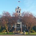
The Crook County Courthouse in Prineville.
.jpg)
See also
 In Spanish: Prineville para niños
