
Crooked River (Oregon) facts for kids
Quick facts for kids Crooked River |
|
|---|---|

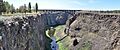
The Crooked River in Smith Rock State Park
|
|

Map of the Crooked River watershed, its main tributaries and downriver connection to the Columbia River via the Deschutes River.
|
|
| Country | United States |
| State | Oregon |
| Counties | Jefferson, Deschutes, Crook |
| City | Prineville |
| Physical characteristics | |
| Main source | South Fork Crooked River 4,775 ft (1,455 m) 43°38′55″N 120°23′30″W / 43.64861°N 120.39167°W |
| River mouth | Deschutes River Lake Billy Chinook 1,950 ft (590 m) 44°34′25″N 121°16′19″W / 44.57361°N 121.27194°W |
| Length | 125 mi (201 km) |
| Basin features | |
| Basin size | 4,500 sq mi (12,000 km2) |
| Tributaries |
|
| Type: | Recreational |
| Designated: | October 28, 1988 |
The Crooked River is a 125-mile-long river in Oregon, a state in the United States. It is a tributary of the Deschutes River. The Crooked River starts where two smaller rivers meet: the South Fork Crooked River and Beaver Creek. The South Fork is the bigger one. The Deschutes River eventually flows into the Columbia River.
Contents
Where Does the Crooked River Flow?
The Crooked River begins in central Oregon. Its main source, the South Fork Crooked River, starts in a remote area near the borders of Deschutes, Lake, and Harney counties. It flows north for about 76 miles (122 km).
Beaver Creek also feeds the Crooked River. It starts in Grant County with two branches, North Fork and South Fork Beaver Creek. These two branches join, and then Beaver Creek flows west.
The main Crooked River forms when the South Fork and Beaver Creek meet near Paulina. From there, the river flows west. It picks up other streams like the North Fork Crooked River and Ochoco Creek.
The river then flows between the Ochoco Mountains and the Maury Mountains. It passes by Post, which is the geographic center of Oregon. Further downstream, the river flows into Prineville Reservoir. This lake was created by Bowman Dam.
After the dam, the river turns north towards Prineville, Oregon. Here, it is joined by Ochoco Creek. The Crooked River then flows northwest. It finally empties into Lake Billy Chinook. This lake is formed by the Round Butte Dam on the Deschutes River.
A part of the Crooked River, about 17.8 miles (28.6 km) long, is special. It's called a "recreational" part of the National Wild and Scenic Rivers System. This means it's protected for its natural beauty and for people to enjoy.
A Look Back: History of the River

The Crooked River and its smaller streams were once very important for fish. Fish like spring Chinook salmon, steelhead trout, and Pacific lamprey used to swim up the river to lay their eggs. Other fish like Columbia River redband trout also lived here.
However, fish populations started to decrease in the early 1800s. This happened because people began taking water from the river for farming.
Long ago, explorers described the lower Crooked River as having wide, grassy areas. They saw many willow trees, which is why the area was called "Ochoco" (a word for willow in the Paiute language). Beavers were also very common, especially in the upper parts of the river. Fur trappers visited the area often until most of the beavers were gone.
Over time, dams were built on the river and its branches. The Cove Power Plant, built around 1910, made it hard for salmon to swim upstream. Ochoco Dam, built in 1920, completely blocked fish passage.
Later, Round Butte Dam was built on the Deschutes River in the 1950s. It was supposed to help fish pass, but it didn't work well. This stopped fish like salmon from reaching their old spawning grounds in the Crooked River. Today, redband trout are the only native game fish left in the Crooked River basin. There are now efforts to help fish pass these dams again.
Farmers started using the river's water for irrigation in the 1800s. Two big reservoirs, Prineville Reservoir and Ochoco Reservoir, were built to store water for summer farming. Because of this, most of the Crooked River's water below Prineville is used for irrigation during the summer.
Fun Things to Do at the Crooked River
Fishing Adventures

Fishing in the river above Prineville Reservoir is not usually very good. This is due to water being taken for irrigation, dry periods, and changes to the riverbanks.
However, Prineville Reservoir is a great spot for fishing! This lake is about 15 miles (24 km) long. You can catch rainbow trout, smallmouth bass, largemouth bass, catfish, crappie, and even crayfish. You can fish here all year from a boat or from the shore.
Below Bowman Dam, which creates the reservoir, the fishing is excellent. The Crooked River here is known as one of Oregon's best trout streams. The 7 miles (11 km) of river below the dam are especially good. The water stays cool because of releases from the reservoir, which helps many redband trout live there. This area is open all year for fly fishing.
Camping Under the Stars
Prineville Reservoir State Park has places to camp. You can find tent sites, spots for recreational vehicles (RVs), and even log cabins. The park is open for camping and day visits all year.
Next to the state park is the Prineville Reservoir Wildlife Area. You can also camp here, go boating, hike, and watch wildlife.
The Lower Crooked Wild and Scenic River area also has campsites. There are nine developed campsites below Bowman Dam. Most are for single families, and two are for groups. All have toilets, but only one, Chimney Rock, has drinking water. There are also hiking trails nearby, like the Chimney Rock Trail.
Near Terrebonne, you can find Smith Rock State Park. This park has an open area for tent camping. However, RV camping, open fires, and sleeping in cars are not allowed. This park is open for tenting and day use all year.
Boating Fun
Prineville Reservoir and its state park are perfect for boating. You can go kayaking, paddle boating, waterskiing, wakeboarding, and windsurfing. The state park has places to tie up your boat during the summer.
A part of the river below Bowman Dam, about 8 miles (13 km) long, is good for canoeing. But it can get crowded with people fishing. Further downstream from Prineville, expert kayakers sometimes paddle challenging sections of the river.
Other Outdoor Activities
- Ochoco State Scenic Viewpoint: This spot is on a hill overlooking Prineville. It offers amazing views of the Crooked River and the Ochoco Mountains. It's also home to some rare plants.
- Smith Rock State Park: Located near Terrebonne, this park is famous for rock climbing. It has thousands of climbing routes. You can also find hiking and biking trails in its rugged canyons. The Crooked River helped create the unique rock formations here over millions of years. Besides climbing, you can swim, fish, take photos, have picnics, and watch wildlife.
- Peter Skene Ogden State Scenic Viewpoint: This viewpoint is along U.S. Route 97. It offers stunning views of the Crooked River Gorge, which is about 300 feet (91 m) deep. It's a great place for a picnic.
- The Cove Palisades State Park: This large park is located along Lake Billy Chinook. It has camping areas, cabins, a marina, and a restaurant. You can rent houseboats, play basketball, and visit a camp store. The Crooked River Campground within the park is open from spring to late September.
Images for kids
-
Crooked River Railroad Bridge spanning the canyon at Peter Skene Ogden State Scenic Viewpoint along U.S. Route 97
_pano.jpg)
