
South Fork Crooked River facts for kids
Quick facts for kids South Fork Crooked River |
|
|---|---|

Lower river west of Paulina
|
|

Location of the mouth of South Fork Crooked River in Oregon
|
|
| Country | United States |
| State | Oregon |
| County | Deschutes and Crook |
| Physical characteristics | |
| Main source | Ram Lake (dry) near Hampton, Deschutes County 4,779 ft (1,457 m) 43°38′55″N 120°23′40″W / 43.64861°N 120.39444°W |
| River mouth | Crooked River near Paulina, Crook County 3,622 ft (1,104 m) 44°06′05″N 120°03′04″W / 44.10139°N 120.05111°W |
| Length | 76 mi (122 km) |
| Basin features | |
| Basin size | 1,530 sq mi (4,000 km2) |
The South Fork Crooked River is a river in the state of Oregon, United States. It flows for about 76 miles (122 km) (122 km). This river is a branch, or tributary, of the larger Crooked River.
Contents
Where Does the South Fork Crooked River Start and End?
The South Fork Crooked River begins in Deschutes County. Its source is near a dry lake called Ram Lake, southeast of a place called Hampton. From there, the river flows east.
How Does the River Flow?
As it flows, the river passes under U.S. Route 20 at Hampton. It then continues flowing east and north for about 6 miles (10 km) (10 km). After this, it enters Crook County.
Soon after entering Crook County, the river gets more water from Buck Creek. This creek joins the South Fork from its right side. The river then flows through Logan Reservoir.
Continuing north, the South Fork Crooked River receives Sand Hollow Creek from its left side. Then, Twelvemile Creek joins it from the right. Finally, the river flows under Oregon Route 380 (Southeast Paulina Highway). Just north of this highway, the South Fork Crooked River joins Beaver Creek. When these two rivers meet, they form the main Crooked River. This meeting point is about 125 miles (201 km) (201 km) from where the Crooked River joins the Deschutes River.
What is the South Fork Crooked River Basin Like?
The area that the South Fork Crooked River drains is called its basin or watershed. This basin is quite large, covering about 1,530 square miles (4,000 km2) (3,963 km²). Not many people live in this area.
What Kinds of Land Are in the Basin?
Most of the land in the basin, about 75 percent, is rangeland. Rangeland is open country used for grazing animals. The rest of the basin has a mix of forests, areas for growing hay, and pastures for animals.
How Much Rain Does the Basin Get?
The amount of rain and snow (called precipitation) that the basin receives changes depending on the location. Near where the river starts, it gets less than 9 inches (230 mm) (230 mm) of precipitation each year. However, in the Ochoco Mountains, which are on the northeastern edge of the basin, it can get as much as 35 inches (890 mm) (890 mm) of precipitation.
Images for kids
-
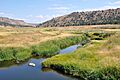
Lower river west of Paulina
