Ochoco Mountains facts for kids
Quick facts for kids Ochoco Mountains |
|
|---|---|
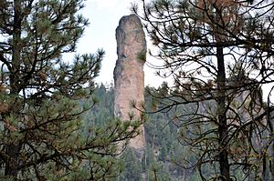
Steins Pillar in ponderosa pine forest
|
|
| Highest point | |
| Peak | Lookout Mountain |
| Elevation | 6,926 ft (2,111 m) |
| Dimensions | |
| Length | 114 mi (183 km) north–south |
| Width | 86 mi (138 km) |
| Geography | |
| Country | United States |
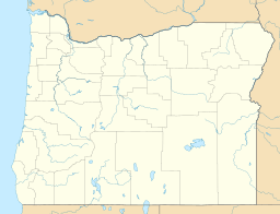
| Range coordinates | 44°26′35″N 120°23′37″W / 44.44306°N 120.39361°W |
| Parent range | Blue Mountains province |
| Geology | |
| Age of rock | Permian, Triassic, Jurassic and Eocene |
| Type of rock | Accreted and erupted igneous rock |
The Ochoco Mountains are a beautiful mountain range in central Oregon, United States. They are found at the western edge of the larger Blue Mountains. These mountains were formed over millions of years. Ancient rocks were slowly pushed up by volcanic eruptions. This created the unique Clarno Formation.
Today, the tallest point in the range is Lookout Mountain. On the west side of the mountains, you'll see tall ponderosa pine trees. On the east side, western juniper trees are very common. The western part of the mountains is managed by the Ochoco National Forest. The southeastern part is looked after by the Malheur National Forest. People enjoy the Ochoco Mountains for many activities. These include hiking, camping, bird watching, rockhounding, and hunting. In winter, it's a great place for cross-country skiing.
Contents
Exploring the Ochoco Mountains
The Ochoco Mountains stretch about 114 miles (183 km) from north to south. They are about 86 miles (138 km) wide from east to west. The highest peaks in this range offer amazing views.
Here are the eight tallest peaks:
- Lookout Mountain, 6,926 feet (2,111 m)
- Spanish Peak, 6,871 feet (2,094 m)
- Mount Pisgah, 6,816 feet (2,078 m)
- Round Mountain, 6,755 feet (2,059 m)
- East Point, 6,625 feet (2,019 m)
- North Point, 6,607 feet (2,014 m)
- Wolf Mountain, 6,483 feet (1,976 m)
- View Point, 6,266 feet (1,910 m)
How the Mountains Were Formed
The Ochoco Mountains are the western part of the Blue Mountains province. The Blue Mountains are not just one range. They are a group of ranges, basins, and valleys. They stretch from southeast Washington down to central Oregon. They end near Prineville.
The Ochoco part of this area is a wide, uplifted plateau. It is made of rocks that are 300 to 200 million years old. These rocks were carried by the Pacific Plate and added to the land. This happened about 100 million years ago. Then, about 50 to 37 million years ago, volcanic eruptions slowly pushed them up. This formed the Clarno Formation.
Later, from 37 to 17 million years ago, volcanoes in the western Cascade Range spread ash across eastern Oregon. This created the John Day Formation. From 17 to 14 million years ago, huge volcanic eruptions covered much of the area. They left behind basalt flows, forming the Columbia River Basalt Group. Since then, the land has continued to move and lift. This has caused a lot of erosion, shaping the landscape we see today. Steins Pillar is a great example of this erosion.
During the Eocene epoch, about 50 to 37 million years ago, volcanoes in central Oregon were very active. They left layers of lava and ash up to 1,000 feet (300 m) thick. Large mudflows, called lahars, were also common. These mudflows often covered and preserved plants and animals. This created amazing fossil beds. Today, you can find fossils of ancient trees, fruits, nuts, and flowers in the Ochoco Mountains. You might also find fossilized animals like horses, camels, rhinoceros, and even hippopotami!
Plants and Animals of the Ochocos
The plants in the Ochoco Mountains change depending on where you are. On the western slopes and in the valleys, you'll find old ponderosa pine forests. On the drier eastern and southern slopes, western juniper and sagebrush are common. The high mountain meadows are full of colorful wildflowers. Some areas even have ferns. Big Summit Prairie, in the middle of the Ochocos, is famous for its beautiful spring wildflower displays.
Ponderosa pine trees are the main type of tree in most of the Ochoco Mountains. These pines grow well at elevations from 3,000 to 6,000 feet (910 to 1,830 m). Shrubs like Manzanita, antelope bitterbrush, and ceanothus are common here. The ground is often covered with Idaho fescue and Ross' sedge. Ponderosa pine forests can handle dry weather and small wildfires.
Many birds live in these pine forests. You might see northern flickers, hairy woodpeckers, red-tailed hawks, and Steller's jays. These forests are also important winter homes for mule deer and Rocky Mountain elk.
On the drier eastern side of the Ochoco Mountains, western juniper trees grow. They can survive with as little as 8 inches (200 mm) of rain each year. These juniper woodlands cover large areas from 3,000 to 4,000 feet (910 to 1,220 m) high. Antelope bitterbrush and sagebrush are common shrubs. The ground cover includes Idaho fescue and bluebunch wheatgrass. Juniper woodlands are home to mountain bluebirds, Townsend's solitaires, and ferruginous hawks in spring and summer. Many small mammals and lizards live here too, and they are often hunted by coyotes.
Big Summit Prairie is a large meadow high up in the Ochoco Mountains. It covers about 20 square miles (52 km2). The prairie has many water-loving grasses. Some areas are overgrown with willows and other shrubs. Common plants on the ground include tufted hairgrass, elephant's head, and horsetail. Quaking aspen trees with shrubs attract wildlife not found elsewhere in the Ochocos.
Birds like sandhill cranes, Wilson's snipes, long-billed curlews, and northern harriers are common. Even the rare dickcissel has been seen here. Larger animals include mule deer, pronghorn, Belding's ground squirrels, northern pocket gophers, meadow mice, and coyotes. Rocky Mountain elk also move into the area in the fall.
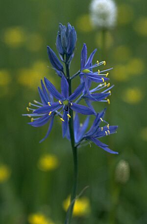
Big Summit Prairie is especially known for its wildflowers and butterflies. From April through June, the meadow is covered in flowers. The first to bloom are usually grass widow, wild parsley, and shooting stars. From May through June, Wyethia, buttercups, and camas add their colors. In drier spots, bitterroots bloom with large white and pink flowers. In June and July, other flowers appear. These include Missouri iris, larkspur, Indian paintbrush, checkermallow, and arrowleaf balsamroot.
One special plant is Peck's mariposa lily. It's a type of Calochortus with lavender petals. This plant is found only in the Ochoco Mountains! Many butterfly species fly around Big Summit Prairie. These include hairstreaks, skippers, eastern tailed-blues, Lycaenidae, checkerspots, fritillarys, swallowtails, admirals, and tortoiseshells.
Fun Activities in the Ochocos
Most of the Ochoco Mountains are public land. They are managed by the United States Forest Service. The Ochoco National Forest looks after most of the mountain area. However, the southeastern part is in the Malheur National Forest. Some land is also managed by the Bureau of Land Management. Many fun activities are popular here. These include hiking, fishing, camping, hunting, horseback riding, bird watching, and rockhounding.
The Ochoco National Forest has 27 campgrounds in or near the Ochoco Mountains. Some of the largest are Antelope Flat Reservoir, Ochoco Divide, Walton Lake, and Wildcat campgrounds. The Malheur National Forest also has campgrounds in the Ochoco Mountains. The biggest is at Delintment Lake.
- Antelope Flat Reservoir campground has 24 campsites. It's surrounded by a beautiful ponderosa pine forest. The reservoir is a 10-minute walk away. The campground is at 4,600 feet (1,400 m) above sea level. You can find drinking water, picnic tables, fire pits, and toilets here. It's usually quiet, except on holiday weekends. Fishing, swimming, boating, and hiking are popular activities.
- Ochoco Divide Campground is in an old ponderosa pine forest. It's just off U.S. Highway 26, about 30 miles (48 km) east of Prineville. The campground is at 4,600 feet (1,400 m) above sea level. It has 28 campsites, picnic tables, fire pits, and toilets. Many travelers stop here overnight. It's often full at night but very quiet during the day. Bandit Springs rest stop is one mile (1.6 km) west. This rest stop is the start of several hiking trails. These trails are great for hiking and mountain biking in summer. In winter, they are perfect for cross-country skiing.
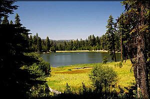
- Walton Lake is a small lake surrounded by old ponderosa pines and mountain meadows. Rainbow trout are put into the lake each summer for fishing. Two hiking trails are nearby. The Walton Lake Trail is a one-mile (1.6 km) loop around the lake. The Round Mountain National Scenic Trail is a 7.5-mile (12.1 km) hike. This trail offers chances to see mountain wildlife and many birds. The campground is at 5,000 feet (1,500 m) above sea level. It has drinking water, picnic tables, fire pits, level tent sites, and toilets. There's also a picnic area with tables, grills, a sandy beach, and a fishing pier. Fishing, swimming, boating, and hiking are popular here.
- Wildcat Campground is at the southwest edge of the Mill Creek Wilderness. It's about 19 miles (31 km) from Prineville. The campground is at 3,700 feet (1,100 m) in elevation. It has 17 sites, drinking water, picnic tables, fire pits, and toilets. A trail leading into the Mill Creek Wilderness is next to the campground. It connects to many hiking trails in the Mill Creek and Twin Pillars areas.
- Delintment Lake Campground is about 45 miles (72 km) northwest of Burns. The campground is at 5,600 feet (1,700 m) above sea level. It has 33 sites, drinking water from a hand-pump, 12 picnic sites, and toilets. Hiking, fishing, swimming, boating, and watching wildlife are popular activities at Delintment Lake.
The unique rocks of the Ochoco Mountains attract many rockhounds every summer. The Bureau of Land Management and the Ochoco National Forest have special areas. Here, rockhounds can search for agate, jasper, petrified wood, petrified moss, and dendrite. You can collect rocks for your personal use. Collecting for selling is not allowed.
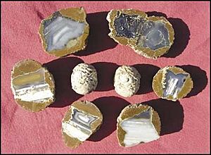
You can find Thundereggs at Whistle Springs. Even though people have been collecting here for many years, good quality thundereggs are still found. There are also some rare rocks and minerals in central Oregon near the Ochoco Mountains. These include opals, amethyst, gem quality calcite, cinnabar, selenite, gypsum, and amygdaloid nodules.
Wild and Protected Areas
The Ochoco National Forest has three special wilderness areas in the Ochoco Mountains. These are the Bridge Creek Wilderness, the Black Canyon Wilderness, and the Mill Creek Wilderness. These areas are protected to keep them wild and natural.
- The Bridge Creek Wilderness is a very remote place. At 5,400 acres (22 km2), it is the smallest wilderness in Oregon. Not many people visit, except during the fall hunting season. It has steep, forested slopes and flat, barren areas. There are also some mountain meadows. This wilderness is an important winter home for elk. Other large animals here include mule deer, black bear, and cougar. Birds like Pileated woodpeckers, goshawks, and prairie falcons build nests in the Bridge Creek area. There are no trails in the Bridge Creek Wilderness. This means it's best for experienced outdoor adventurers.
- The Black Canyon Wilderness covers 13,400 acres (54 km2). Its elevation ranges from 3,900 to 6,400 feet (1,200 to 2,000 m). The Black Canyon area has dense forests and steep basalt cliffs. Many animals live here, including deer, elk, black bear, and cougar. Wildflowers like crimson columbine, lupine, and Indian paintbrush grow throughout the wilderness. There are several hiking trails, but they are all very rugged.
- The Mill Creek Wilderness includes 17,000 acres (69 km2) of protected land. This wilderness is known for its deep canyons and tall rock towers. These include two volcanic plugs called the Twin Pillars. You can find these two rock formations along the Twin Pillars Trail National Recreational Trail. The trail starts at Wildcat Campground, just outside the wilderness. The Mill Creek Wilderness has a 21-mile (34 km) network of trails. Both hikers and horse riders use these trails. However, the trails are very rugged with many steep climbs and descents. The wilderness has dense pine and fir forests. Mill Creek and its smaller streams flow through it. Elk and deer are common in the Mill Creek area. You can also find black bear, wild turkey, pileated woodpeckers, and goshawks. In the fall, the Mill Creek Wilderness is a popular place for hunters.
 | Selma Burke |
 | Pauline Powell Burns |
 | Frederick J. Brown |
 | Robert Blackburn |


