Grant County, Oregon facts for kids
Quick facts for kids
Grant County
|
|
|---|---|
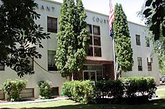
Grant County Courthouse in Canyon City
|
|
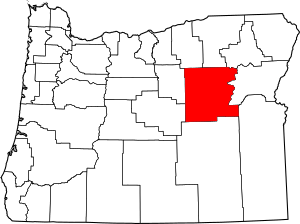
Location within the U.S. state of Oregon
|
|
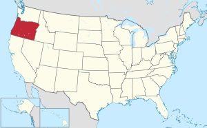 Oregon's location within the U.S. |
|
| Country | |
| State | |
| Founded | October 14, 1864 |
| Named for | Ulysses S. Grant |
| Seat | Canyon City |
| Largest city | John Day |
| Area | |
| • Total | 4,529 sq mi (11,730 km2) |
| • Land | 4,529 sq mi (11,730 km2) |
| • Water | 0.7 sq mi (2 km2) 0.02%% |
| Population
(2020)
|
|
| • Total | 7,233 |
| • Estimate
(2023)
|
7,215 |
| • Density | 1.6/sq mi (0.6/km2) |
| Time zone | UTC−8 (Pacific) |
| • Summer (DST) | UTC−7 (PDT) |
| Congressional district | 2nd |
Grant County is one of the 36 counties in the U.S. state of Oregon. In 2020, about 7,233 people lived here. This makes it Oregon's fourth-smallest county by population. The main town, or county seat, is Canyon City.
The county is named after Ulysses S. Grant. He was a famous general during the American Civil War. Later, he became a U.S. President. Grant County is part of what is known as Eastern Oregon.
Contents
History of Grant County
Grant County was created on October 14, 1864. It was formed from parts of older Wasco and Umatilla counties. Before this, people had to travel far to The Dalles for court cases. This made it hard to enforce laws and do business.
In 1889, a large part of southern Grant County became Harney County. Then, in 1899, a small piece of northwestern Grant County helped form Wheeler County.
Gold Rush and Government Beginnings
Gold was found in 1862 at Whiskey Flat. Within ten days, about 1,000 miners set up camps along Canyon Creek. This sudden increase in people meant a local government was needed.
Grant County's government follows the rules of the Oregon Constitution. It uses an old-style county government system. This includes a County Court with a County Judge and two Commissioners. Today, the County Court mostly acts as the county's executive branch.
Famous People and County Seats
One famous person who served as County Judge was Joaquin Miller. He was a well-known poet and writer. People called him the "Poet of the Sierras."
Canyon City was the county's main community for many years. When the county started in 1864, Canyon City might have been the biggest town in Oregon. Mining, ranching, and timber brought people to the area. Communities grew around these industries. Canyon City still celebrates its history with an annual summer festival called "'62 Days." This name remembers the gold discovery in 1862.
Since the 1930s, the city of John Day has been the main economic center. It also has the largest population in the county.
Geography of Grant County
Grant County covers about 4,529 square miles (11,730 square kilometers). Most of this area is land. Only a tiny part, about 0.7 square miles (1.8 square kilometers), is water.
Federal Lands and Forests
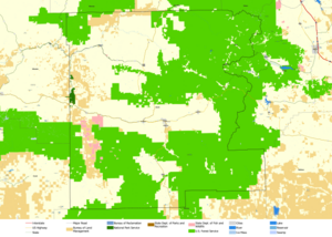
About 63% of the county's land is managed by the U.S. Federal Government. Most of this is controlled by the U.S. Forest Service and the Bureau of Land Management. Grant County includes most of the Malheur National Forest. It also has parts of the Wallowa–Whitman, Umatilla, and Ochoco National Forests. There are over 150,000 acres (607 square kilometers) of special Wilderness Areas here.
Rivers and Mountains
The John Day River starts in Grant County. This river has more "Wild and Scenic River" sections than any other river in the United States. This means parts of it are protected for their natural beauty.
The county's elevation changes a lot. It goes from 1,820 feet (555 meters) near Kimberly to 9,038 feet (2,755 meters) at the top of Strawberry Mountain. The land includes grasslands, rolling hills, steep canyons, and rugged mountains. Some parts are high desert with sagebrush.
Grant County is home to the southern part of the Blue Mountains. The forests here have widely spaced trees and not much underbrush. This made it easy for early travelers to move around. The trees include Ponderosa Pine, Douglas-fir, and Western Larch. At higher elevations, you can find Engelmann Spruce and Subalpine Fir. Along rivers, there are cottonwoods. You can also find wildflowers, huckleberries, and wild strawberries.
Unique Organisms
Grant County might be home to one of the largest living organisms in the world. This is a giant fungus called Armillaria solidipes. It lives in the Malheur National Forest. This fungus covers about 8.9 square kilometers (2,200 acres). Scientists think it weighs between 8,500 and 10,500 tons. It could be between 2,000 and 8,500 years old!
Geological History
The land in Grant County has changed a lot over time. Millions of years ago, much of the county was an ancient seabed. Later, volcanoes and lava flows changed the landscape. The John Day Fault, a rare east-west fault, helped form the Strawberry and Aldrich mountains.
The geology of Grant County is very interesting. It has one of North America's largest fossil sites: The John Day Fossil Beds National Monument. This area became a National Monument in 1974. Fossils show that long ago, the area had forests, shellfish, saber-toothed cats, and ancient horses.
Valuable metals like gold, silver, and copper are found here. Gold mining was a big reason people settled in the area.
Rivers and Climate
Most of Grant County is drained by the four forks of the John Day River. All these rivers start in the county. The John Day River system drains about 7,900 square miles (20,460 square kilometers). It is the third-longest free-flowing river in the lower 48 U.S. states.
The county's climate ranges from dry to mild. The amount of rain and snow changes across the county. Valleys get about 12 to 14 inches (300-350 mm) of rain each year. Mountains can get over 40 inches (1,000 mm). Winter snow in the mountains is important. It melts and provides water for rivers and underground water.
Temperatures vary greatly. In July, Monument can be 90°F (32°C) during the day and 50°F (10°C) at night. In January, it can be 42°F (6°C) during the day and 22°F (-6°C) at night. Seneca is cooler, with July highs around 80°F (27°C) and lows around 38°F (3°C). January lows can drop to 8°F (-13°C).
Grant County usually has about 200 clear or mostly sunny days each year. It also has about 300 days that are clear, mostly sunny, or partly sunny.
Adjacent counties
Grant County borders eight other counties in Oregon. This is more than any other county in the state.
- Morrow County - northwest
- Umatilla County - north
- Union County - northeast
- Baker County - east
- Malheur County - southeast/Mountain Time Border
- Harney County - south
- Crook County - southwest
- Wheeler County - west
National protected areas
- John Day Fossil Beds National Monument (part)
- Malheur National Forest (part)
- Ochoco National Forest (part)
- Umatilla National Forest (part)
- Wallowa–Whitman National Forest (part)
Demographics
| Historical population | |||
|---|---|---|---|
| Census | Pop. | %± | |
| 1870 | 2,251 | — | |
| 1880 | 4,303 | 91.2% | |
| 1890 | 5,080 | 18.1% | |
| 1900 | 5,948 | 17.1% | |
| 1910 | 5,607 | −5.7% | |
| 1920 | 5,496 | −2.0% | |
| 1930 | 5,940 | 8.1% | |
| 1940 | 6,380 | 7.4% | |
| 1950 | 8,329 | 30.5% | |
| 1960 | 7,726 | −7.2% | |
| 1970 | 6,996 | −9.4% | |
| 1980 | 8,210 | 17.4% | |
| 1990 | 7,853 | −4.3% | |
| 2000 | 7,935 | 1.0% | |
| 2010 | 7,445 | −6.2% | |
| 2020 | 7,233 | −2.8% | |
| 2023 (est.) | 7,215 | −3.1% | |
| U.S. Decennial Census 1790–1960 1900–1990 1990–2000 2010–2020 |
|||
Population in 2010
In 2010, Grant County had 7,445 people living in 3,352 households. The population density was about 1.6 people per square mile. Most residents, 95%, were white. About 1.2% were American Indian. People of Hispanic or Latino origin made up 2.8% of the population.
The average age of people in the county was 50 years old.
Communities
Cities
- Canyon City (county seat)
- Dayville
- Granite
- Greenhorn
- John Day
- Long Creek
- Monument
- Mount Vernon
- Prairie City
- Seneca
Unincorporated communities
Economy
When gold was found near Canyon City in June 1862, many miners came to the area. By 1900, about $16 million in gold had been mined from the Canyon City area alone. Mining was the main industry until October 1942. At that time, gold mining was made illegal by a special order during World War II. This caused many mining towns to be abandoned. Grant County was second only to Baker County in gold production in Oregon.
Agriculture and Timber
Because of its natural resources, Grant County also developed strong farming, ranching, and timber industries. In the early days, sheep farming was very important. The area had some of the largest sheep herds in the world. They supplied a lot of wool to places like Pendleton Wool Works.
Later, cattle ranching became the main type of farming. It is still important today. Crop farming and dairy farms were smaller. The timber industry grew quickly in the 1920s and after World War II. Raising livestock and harvesting timber are still key parts of Grant County's economy. However, their production has decreased recently.
Modern Economy
Grant County has faced economic challenges. It has had one of the highest unemployment rates in Oregon for over 30 years. This is partly due to federal land policies and changes in global markets for timber and farm products.
The county has seen some growth in tourism and outdoor activities like hunting. Some small businesses have also started. About a quarter of the county's workers are employed by the government or public services.
See also
 In Spanish: Condado de Grant (Oregón) para niños
 | Audre Lorde |
 | John Berry Meachum |
 | Ferdinand Lee Barnett |


