
Prairie City, Oregon facts for kids
Quick facts for kids
Prairie City, Oregon
|
|
|---|---|

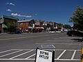
Downtown Prairie City
|
|

Location in Oregon
|
|
| Country | United States |
| State | Oregon |
| County | Grant |
| Incorporated | 1891 |
| Area | |
| • Total | 0.99 sq mi (2.57 km2) |
| • Land | 0.99 sq mi (2.57 km2) |
| • Water | 0.00 sq mi (0.00 km2) |
| Elevation | 3,537 ft (1,078 m) |
| Population
(2020)
|
|
| • Total | 841 |
| • Density | 847.78/sq mi (327.45/km2) |
| Time zone | UTC-8 (Pacific) |
| • Summer (DST) | UTC-7 (Pacific) |
| ZIP code |
97869
|
| Area code(s) | 541 |
| FIPS code | 41-59650 |
| GNIS feature ID | 2411484 |
| Website | www.prairiecityoregon.com |
Prairie City is a small city in Grant County, Oregon, in the United States. In 2020, about 841 people lived there. The city officially became a city on February 23, 1891.
Contents
History of Prairie City
Prairie City started near an old mining camp called Dixie. That camp began in 1862. It was about 3 miles (4.8 km) from the John Day River. But Dixie wasn't a good place for a town anymore because of gold mining. So, Prairie City was chosen instead. It got its first post office in 1870. Jules Le Bret was the first postmaster.
A special train line, called the Sumpter Valley Railway, reached Prairie City in 1907. This train line was about 80 miles (129 km) long. It carried people, goods, and timber from forests. The railway stopped running in the 1930s. Today, a small part of the old train line is used for fun rides. It's like a museum train!
Geography and Location
Prairie City is in eastern Oregon. It sits at the top end of the John Day River valley. The city is about 50 miles (80 km) southwest of Baker City by road. It is also 13 miles (21 km) east of John Day. You can reach it along U.S. Route 26. Strawberry Mountain is right south of the city. It is part of the Malheur National Forest.
The city covers about 0.99 square miles (2.57 square kilometers) of land. There is no water area within the city limits.
People of Prairie City
| Historical population | |||
|---|---|---|---|
| Census | Pop. | %± | |
| 1870 | 100 | — | |
| 1880 | 235 | 135.0% | |
| 1890 | 222 | −5.5% | |
| 1900 | 213 | −4.1% | |
| 1910 | 348 | 63.4% | |
| 1920 | 643 | 84.8% | |
| 1930 | 438 | −31.9% | |
| 1940 | 647 | 47.7% | |
| 1950 | 822 | 27.0% | |
| 1960 | 801 | −2.6% | |
| 1970 | 867 | 8.2% | |
| 1980 | 1,106 | 27.6% | |
| 1990 | 1,117 | 1.0% | |
| 2000 | 1,080 | −3.3% | |
| 2010 | 909 | −15.8% | |
| 2020 | 841 | −7.5% | |
| source: | |||
In 2010, there were 909 people living in Prairie City. There were 402 homes. About 257 of these were families. The city had about 918 people per square mile (354 per square kilometer).
Most people in Prairie City are White (94.6%). Some are Native American (1.3%). A small number are from other backgrounds. About 3.1% of the people are Hispanic or Latino.
The average age in the city was about 49.8 years old. About 20.4% of the people were under 18. About 25.6% were 65 or older. There were slightly more females (50.7%) than males (49.3%).
Economy and Jobs
The main jobs in Prairie City are in ranching and retail stores. There is also a power plant that uses wood for fuel. Public services, like schools and city offices, also provide jobs. Prairie Wood Products is a mill in the city. It makes wood studs from trees in nearby forests.
Education and Culture
Prairie City School teaches children from kindergarten through 12th grade.
Historic Buildings
Prairie City has some interesting old buildings. These include historic stone buildings. The old railway depot is also a special place. The bottom floor of the depot used to be a waiting room and offices for the train station. The second floor was once the home of the station agent.
Today, the second floor of the depot holds the Dewitt Museum. This museum has old tools, furniture, and other items from pioneer times. It also has rocks and minerals from the area. The depot was added to the National Register of Historic Places in 1976.


Nearby Parks
Bates State Park is northeast of Prairie City. It was built where an old lumber mill used to be. You can find it near Austin Junction. This is where U.S. Route 26 and Oregon Route 7 meet.
Images for kids
-
Downtown Prairie City
-

Location in Oregon
See also
 In Spanish: Prairie City (Oregón) para niños
