Strawberry Mountain (Oregon) facts for kids
Quick facts for kids Strawberry Mountain |
|
|---|---|

Strawberry Mountain Peak
|
|
| Highest point | |
| Elevation | 9,042 ft (2,756 m) NAVD 88 |
| Prominence | 4,080 ft (1,244 m) |
| Listing | Oregon county high points |
| Geography | |
| Location | Grant County, Oregon, United States |
| Parent range | Strawberry Mountains |
| Topo map | USGS Strawberry Mountain |
| Geology | |
| Last eruption | 12.5 million years ago |
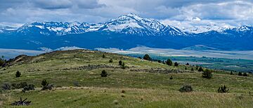
Strawberry Mountain is the tallest peak in the Strawberry Mountains of eastern Oregon in the United States. It is the 30th highest point in all of Oregon. This amazing mountain is part of the Malheur National Forest and is the most important feature of the Strawberry Mountain Wilderness.
Contents
Discovering Strawberry Mountain
The mountain and a nearby stream, Strawberry Creek, got their names from a settler named Nathan Willis Fisk. He chose the name because there were "wild strawberries in abundance there." At first, people called it "Strawberry Butte," but over time, everyone started calling it Strawberry Mountain. That is the name you will find on all official maps today.
How Strawberry Mountain Formed
Strawberry Mountain has a long and exciting history, going back millions of years!
Ancient Rocks and Volcanoes
The base of Strawberry Mountain is made of old volcanic rocks and ocean sediments. These layers were laid down during the Early Jurassic period, about 200 to 145 million years ago. Later, this land became part of the North American Plate.
Around 145 to 66 million years ago, during the Early Cretaceous period, a type of rock called granite pushed its way into this area. This event helped create gold veins in the larger Blue Mountain region. After this, there were many more volcanic eruptions and a lot of erosion over the next 60 million years.
Volcanic Activity
About 16 to 14 million years ago, Strawberry Mountain was very active. It erupted a type of volcanic rock called andesite. These eruptions happened around the same time as the huge Columbia River Basalt Group eruptions. The rocks that make up Strawberry Mountain are often called the Strawberry Volcanics. Scientists believe that about 100 cubic kilometers (24 cubic miles) of material erupted from this area!
Shaping the Landscape
After these volcanoes stopped erupting, the land was squeezed from north to south. Over millions of years, streams and ice age glaciers carved out the mountain. This erosion revealed the inside of the ancient volcano and its early lava flows.
The glaciers also made the valleys wider, creating the U-shaped valleys you can see today. Some of these valleys now hold beautiful alpine lakes. Much of the rock and soil that eroded from Strawberry Mountain settled in the John Day River Valley. This material is known as the Rattlesnake Formation.
Fossils from the Past
Above the gravel of the Rattlesnake Formation, there is a layer of volcanic ash about 100 feet (30 meters) thick. This area is famous for its fossils! Scientists have found the fossilized remains of many animals here. These fossils range from the Eocene to the Miocene epochs, which means they are between 56 and 5.3 million years old. Among these amazing finds are several types of ancient horses, like Eohippus and Merychippus, which are now extinct.
 | Laphonza Butler |
 | Daisy Bates |
 | Elizabeth Piper Ensley |

