
Goose Lake Valley facts for kids
Quick facts for kids Goose Lake Valley |
|
|---|---|

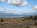
Goose Lake near the Oregon–California border
|
|
| Lua error in Module:Location_map at line 420: attempt to index field 'wikibase' (a nil value). | |
| Length | 47 mi (76 km) north–south |
| Width | 12 mi (19 km) west–east |
| Geography | |
| Country | United States |
| State | Oregon and California |
| Counties | Lake County, Oregon and Modoc County, California |
| Population center | Lakeview, Oregon |
| Borders on | Fremont Mountains, Warner Mountains and Modoc Plateau |
The Goose Lake Valley is a large valley located in the southern part of Oregon and the northeastern part of California in the United States. It's a high valley found at the edge of North America's Great Basin. A big part of the valley floor is covered by Goose Lake. This is a special kind of lake called an endorheic lake, which means water flows into it but doesn't flow out to the ocean. The lake sits right on the border between Oregon and California.
For thousands of years, Native American people lived in the Goose Lake Valley. Later, in the 1800s, explorers and pioneers arrived. A famous wagon trail called the Applegate Trail passed through this valley on its way to southern Oregon. Today, Lakeview, Oregon, is the biggest town in the valley. The main jobs here are ranching (raising livestock) and working in lumber mills. The Goose Lake Valley is also a great place for fun activities like hang-gliding, hunting, fishing, and birdwatching.
Contents
Exploring the Goose Lake Valley
The Goose Lake Valley is located in Lake County, Oregon, and Modoc County, California. It is about 47 miles (76 km) long and 12 miles (19 km) wide.
Lakeview is the largest town in the valley. Two main highways go through the valley and pass through Lakeview. U.S. Route 395 runs north and south, while Oregon Route 140 crosses the valley from east to west. For example, Klamath Falls, Oregon, is 97 miles (156 km) west of Lakeview on Route 140.
Mountains and the Valley Floor
High mountains surround three sides of the valley. These mountains rise thousands of feet above the valley floor. The Warner Mountains are on the east side, and the Fremont Mountains are on the north and west sides.
The highest point overlooking the valley is Crane Mountain in the Warner Mountains. Its top is 8,456 feet (2,577 m) above sea level. To the south and southwest of the valley is the Modoc Plateau.
The valley floor is about 4,900 feet (1,500 m) above sea level. Goose Lake takes up most of this area. The lake's surface is usually 4,705 feet (1,434 m) above sea level. Normally, no rivers flow out of the lake. But when the water level is very high, the south end of the lake can overflow into the Pit River. During very dry times, the lake can even dry up completely!
Many streams flow into the valley from the Fremont and Warner Mountains. Most of the fresh water for Goose Lake comes from the Fremont Mountains.
How the Goose Lake Valley Was Formed
The area around the Goose Lake Valley was shaped by something called faulted blocking. This means huge blocks of the Earth's crust moved up and down along cracks called faults. The valley itself is an alluvial basin. This means it's a low area filled with sediments (like sand, silt, and gravel) carried by water over a long time.
The rocks under the valley were formed by ancient lava flows from the Pliocene and Pleistocene periods. These are covered by Holocene sedimentary deposits. The mountains around the valley are made of basalt rock from the Pliocene and Tertiary periods.
Long, long ago, during the Pleistocene epoch, the entire valley was covered by a single, huge lake. This ancient lake might have been 300 feet (91 m) deep! But over time, during the Holocene epoch, the water levels slowly went down. This left behind the large endorheic lake we know today as Goose Lake. Now, the lake is only about 24 feet (7.3 m) deep at its deepest point.
Weather in the Valley
The climate in the Goose Lake Valley is like other high desert areas in south-central Oregon. This means it has warm summers and very cold winters.
The valley gets about 14.3 inches (36 cm) of rain each year. It also gets a good amount of snow, averaging 53.6 inches (136 cm). The snow that falls on the surrounding mountains melts and feeds the streams that flow into the valley.
Spring is short, so the growing season for plants is only about 100 days. In summer, days are usually warm and dry, but nights can be cool. High temperatures in summer are typically between 75°F (24°C) and 90°F (32°C). Fall days are often clear and crisp, with cold nights. Winters are very cold, with daily temperatures usually below freezing from December to February. Winter nights can even drop to -20°F (-29°C).
Amazing Animals and Plants
The Goose Lake Valley is home to many different animal habitats. These include lakes, marshes, riverbanks, grasslands, sage steppes, dry forests, and rocky mountain areas called rimrocks. The elevation ranges from 4,705 feet (1,434 m) at Goose Lake to over 8,456 feet (2,577 m) on Crane Mountain.
Marsh grasses grow along the lake shore. Areas near rivers and streams have quaking aspen, alder, and willow trees. In the steppe and grassland areas, you'll find plants like big sagebrush, bitterbrush, bunchgrass, and fescue. The dry forests have western juniper, ponderosa pine, lodgepole pine, and white fir trees. Beautiful wildflowers like common yarrow, camas, larkspur, elephant-head flower, blazing star, and crane orchids also grow here.

Wildlife in the Valley
The valley has many common high desert mammals. These include pronghorn, elk, mule deer, black bear, cougar, bobcat, and coyotes. Smaller mammals like jackrabbits, ground squirrels, and chipmunks also live here.
The Goose Lake Valley is a very important stop for birds. It's on the western flyway, a route birds use to fly from Mexico to their breeding grounds in the Arctic. In the spring, thousands of Canada geese, snow geese, Ross' geese, and whistling swans stop in the valley to eat and rest. Many shorebirds also migrate through the valley, such as black-necked stilts, American avocets, and spotted sandpipers. In the fall, these birds pass through again on their way south.
Many bird species also nest around Goose Lake. Shorebirds like American avocets, willets, and killdeer build nests near the lake. The wetlands north of the lake are breeding areas for Canada geese, sandhill cranes, and different types of ducks. These wetlands are also important for Clark's grebes, white-faced ibis, and great egrets. Tundra swans and American white pelicans use the area too. In winter, over 10,000 Canada geese used to stay at the lake.

In the canyons, riverbanks, and rocky areas around the valley, you can find birds like mountain chickadees, finches, Townsend's solitaires, and lazuli buntings. In the open valley, where cottonwood and willow trees grow, you might see Bullock's orioles, tree swallows, and American goldfinches. California quail are common all year round throughout the valley. Larger birds like Cooper's hawks and bald eagles also live here.
Fish in the Streams
Several types of trout live in the streams that flow into the Goose Lake Valley. These include rainbow trout, brook trout, and the protected bull trout. A special fish called the Goose Lake redband trout is found only in Goose Lake and its connecting streams.
Because Goose Lake can dry up during droughts, the fish populations in the streams are very important for the survival of the redband trout. In streams, these redbands usually grow to 12 to 14 inches (30 to 36 cm) long during their five-year life. But the redbands that live in Goose Lake can grow much bigger, up to 36 inches (91 cm)! California has named the Goose Lake redband trout as one of its special "Heritage Trout" species.
A Look Back at History
Native Americans lived in the Goose Lake Valley for thousands of years before European explorers arrived. The Klamath Indians called the big lake Newapkshi. Today, we know it as Goose Lake.
It's not completely clear who was the first European explorer to enter the valley. A map from 1832 shows a "Pit Lake" with hot springs nearby, which seems to be Goose Lake and Hunter's Hot Springs. The first explorer to write about his journey through the valley was John Work, who led a fur trapping trip in 1832.

Pioneer Trails and Early Explorers
The Applegate Trail wagon route, opened in 1846, crossed the southern part of the Goose Lake Valley. Pioneers on this trail came down into the valley from the Warner Mountains through Fandango Pass. They then traveled south along the east side of Goose Lake. At the south end of the lake, the trail split. The Applegate Trail continued west towards southern Oregon, while another path, called the Lassen Cutoff, went south towards the Sacramento Valley.
In 1849, Captain William Horace Warner, an Army engineer, camped in the Goose Lake Valley. He was later killed by Native Americans while returning to his camp. Many places in south-central Oregon are now named after him.
In 1864, Lieutenant Colonel C. S. Drew of the 1st Oregon Cavalry traveled through the valley. Several places along his route, like Drew Creek and Drews Gap, are named after him.
Land and Settlement
In 1865, the United States Congress approved building the Oregon Central Military Wagon Road. This road was supposed to go from Eugene, Oregon, to Fort Boise in Idaho. The company building the road could claim large amounts of land for every mile they built. Because of this, they chose a route that went through lots of good land, including the Goose Lake Valley. This allowed the company to get thousands of acres of valuable grazing land.
For many years, there were legal arguments about who owned this land. This stopped settlers from claiming land for farms and ranches. Finally, the U.S. Supreme Court made a decision. The land eventually went to the Oregon Valley Land Company, which divided it into smaller pieces. These pieces were sold in a big auction in Lakeview, Oregon, in 1909.
In 1867, General George Crook started a campaign to stop Native American raids in south-central Oregon. Fort Warner, located northeast of the Goose Lake Valley, became his main base. Crook's soldiers often passed through the valley. In 1869, the local Paiute Indians signed a treaty, and the Army stopped its operations there.
After the treaty was signed in 1869, settlers began to arrive in the Goose Lake Valley. New Pine Creek was started in 1869, becoming the first community in the valley. M.W. Bullard, one of the first settlers north of Goose Lake, arrived in 1869. He later gave 20 acres (8.1 ha) of his land for a courthouse and sold more land to create a town. That town is now Lakeview, the county seat of Lake County, Oregon.
The first sawmill in the Goose Lake Valley was built in 1872 in California, southeast of Goose Lake. It used a water wheel to power the mill and provided lumber for homes throughout the valley. Since then, making lumber has been an important part of the valley's economy.

Doctor Bernard Daly was very important to the early growth of the Goose Lake Valley. In 1897, he started the Bank of Lakeview. When Lakeview's downtown was destroyed by a fire in 1900, Dr. Daly helped pay for the city to rebuild. He also helped bring the Nevada-California-Oregon Railroad to Lakeview in 1912. Dr. Daly was a County Judge from 1902 until he passed away in 1920. When he died, he left his money to the people of Lake County through the Bernard Daly Educational Fund. This fund has given college scholarships to over two thousand students from Lake County.
How Land is Used Today
Most of the Goose Lake Valley is privately owned farmland. Because of this, agriculture is the main way people earn money in the valley. Most of the farmland is used for ranching cattle. The crops grown are usually used to feed the animals in winter. Since the growing season is short, the main crops are hay, wheat, oats, and barley. There are also apple orchards near Davis Creek, California.
Lumber mills are also a big part of the valley's economy. A law called the Sustained Yield Forest Management Act of 1944 helped protect the local timber industry. This law means that a lot of the timber from Fremont National Forest lands must be sold to mills within 7 miles (11 km) of Lakeview.
The mountain areas that drain into the valley are part of the Fremont National Forest and the Modoc National Forest. These public lands offer many fun things to do, like hang-gliding, hunting, fishing, hiking, birdwatching, boating, and camping.
Goose Lake State Recreation Area is a park managed by the Oregon Parks and Recreation Department. It's on the east side of Goose Lake, right on the Oregon side of the border. The park has places for trailers or RVs, restrooms, picnic tables, and areas for tent camping. Boating and birdwatching are popular activities there. An old orchard inside the park attracts wildlife.
Towns in the Valley

- Davis Creek, California: A small community on the east side of the Goose Lake Valley, near the south end of Goose Lake.
- Lakeview, Oregon: A city near the north end of the Goose Lake Valley. Voters chose it as the county seat of Lake County in 1876.
- New Pine Creek, Oregon: A community on the east side of Goose Lake, just north of the California state line.
- Pine Creek, California: A community on the east side of Goose Lake, just south of the Oregon state line.
Images for kids
-
Goose Lake near the Oregon–California border
-
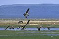
Canada geese taking off from wetland
-
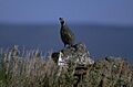
Quail are common in the Goose Lake Valley
-
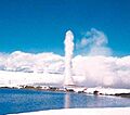
Old Perpetual geyser at Hunter's Hot Springs
-
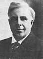
Doctor Bernard Daly
-
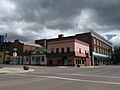
Businesses in downtown Lakeview, Oregon
