Crane Mountain facts for kids
Quick facts for kids Crane Mountain |
|
|---|---|

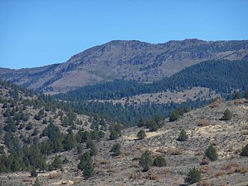
West face of Crane Mountain
|
|
| Highest point | |
| Elevation | 8,451 ft (2,576 m) NAVD 88 |
| Prominence | 2,336 ft (712 m) |
| Listing | Oregon county high points |
| Geography | |
| Location | Lake County, Oregon, U.S. |
| Parent range | Warner Mountains |
| Topo map | USGS Crane Mountain |
| Geology | |
| Mountain type | Fault block |
| Climbing | |
| Easiest route | Steep rough road |
| Normal route | Hiking trail |
Crane Mountain is a super tall peak in the Warner Mountains range. It's the highest point in Lake County, Oregon, U.S.. You can find it southeast of Lakeview in south-central Oregon. This mountain is part of the Fremont–Winema National Forest. A long time ago, there was a United States Forest Service fire lookout tower near the top, but it was taken down in 1972. Today, the Crane Mountain National Recreation Trail runs along the mountain's top, going north and south.
Contents
What Makes Crane Mountain Special?
Crane Mountain is a big peak at the northern end of the Warner Mountains. It's in the part of the western United States known for its "basin and range" landscape. The mountain is inside the Fremont–Winema National Forest. It's about 5 miles (8 km) southeast of Lakeview.
The very top of Crane Mountain is 8,451 feet (2,576 meters) high. This makes it the tallest spot in all of Lake County, Oregon! It stands out with a topographic prominence of 2,336 feet (712 meters).
How Crane Mountain Was Formed
Crane Mountain is a fault block mountain. This means it was formed when huge cracks, called faults, in the Earth's crust caused a large block of land to tilt and lift up. This is common in southeast Oregon. The main rock you'll find here is basalt, which is a dark, volcanic rock.
The mountain has a steep cliff on its west side. This cliff overlooks the Goose Lake Valley. As the mountain tilted, it exposed older layers of rock. You can see rhyolite tuff (a type of rock made from volcanic ash) on the western side.
Cool Rocks and Minerals
If you look closely in the rhyolite layers, you might find agates and thunder eggs! Agates are beautiful, banded stones. Thunder eggs are round rocks with cool patterns inside. It's also rare to find small amounts of gold-bearing quartz on the southern slope. This is unusual because the area is mostly basalt. The soil around the mountain comes from broken-down basalt and tuff.
Rivers and Valleys Around the Mountain
Crane Mountain is surrounded by interesting landscapes. To the west is the Goose Lake Valley, and to the east is the Warner Valley. Both of these valleys are used for farming.
Five creeks flow from Crane Mountain all year long. Crane Creek drains the northern part. Cogswell Creek and Kelley Creek drain the western and southwestern parts. These three creeks flow into Goose Lake. Willow Creek drains the northeast, and Deep Creek drains the east and southeast. These two creeks flow into the Warner Valley, helping to fill the Warner Lakes.
Weather on Crane Mountain
In summer, the high-desert country around Crane Mountain is usually sunny. Days on the mountain are often mild, but nights can get quite chilly.
Winter on Crane Mountain is very cold. Snow usually starts falling in November and can stay on the ground until May. The mountain gets a lot of precipitation, about 40 to 65 inches (102 to 165 cm) each year. Most of this is snowfall. This is one of the wettest areas in the Klamath Ecological Province, which covers parts of Oregon and California.
Plants and Animals of Crane Mountain
The lower and middle parts of Crane Mountain are covered by a mixed forest. At lower elevations, you'll see ponderosa pine trees and some western juniper. Higher up, there are mostly ponderosa pine and western white pine, with Mountain mahogany on drier slopes. Even higher, near the top, you'll find whitebark pine and subalpine fir.
Wildflowers and Meadows
The ground in most areas is covered by low sagebrush. In the mountain meadows, you can see quaking aspen trees. In late spring and early summer, these meadows burst with colorful wildflowers. Some common ones are Indian paintbrush, yellow balsamroots, phacelia, Penstemon, Clarkia, common yarrow, and spreading phlox.
Wildlife Living on the Mountain
Crane Mountain is home to many different animals. You might spot large mammals like mule deer, Rocky Mountain elk, coyotes, bobcats, and cougars. Smaller animals include American badgers, porcupines, striped skunks, black-tailed jackrabbits, white-tailed jackrabbits, pygmy rabbits, golden-mantled ground squirrels, and least chipmunks.
Many birds live in the forests around Crane Mountain. These include the pygmy nuthatch, juniper titmouse, mountain chickadee, blue-gray gnatcatcher, and many types of flycatchers and vireos. You can also find Woodhouse's scrub jay, Steller's jay, and Clark's nutcracker.
There are at least five kinds of woodpeckers here, like the red-breasted sapsucker and black-backed woodpecker. Many birds of prey also soar above Crane Mountain. These include different types of owls, prairie falcons, northern harriers, red-tailed hawks, golden eagles, and bald eagles.
Crane Mountain's Past
Early Encounters
In the summer of 1867, a scout named Archie McIntosh led a group of 18 Warm Springs or Shoshone scouts. They were looking for a Paiute group led by Chief Ocheho. As they followed a trail up Crane Mountain, the Paiutes surprised them. There was a skirmish, and the scouts had to retreat. The Paiutes chased them for a long time.
A few days later, Colonel Crook led 360 soldiers and scouts to search for the Paiutes. They found a strong Native American fort on Crane Mountain, but it was empty.
How the Mountain Got Its Name
After the army moved the native people from the area, settlers started to live in the Goose Lake Valley. Crane Mountain was named after Samuel Crane. He was an early pioneer who settled near Goose Lake at the base of the mountain in 1869. Cogswell Creek was also named after an early pioneer.
The Fire Lookout Tower
In 1952, the United States Forest Service built a fire lookout tower on Crane Mountain. It was a tall wooden tower with a small cabin for the lookout to live in. This lookout was a little north of the mountain's top, at 8,347 feet (2,544 meters) high. It replaced an older lookout nearby. The tower and cabin were used for twenty years. In 1972, the tower and other buildings were taken down.
Fun Things to Do on Crane Mountain
Crane Mountain offers many outdoor activities, especially in the summer. You can go hiking, horseback riding, and mountain biking. It's also a great place for bird watching and wildlife viewing. Many people enjoy camping and photography here. Some trails on the south side are even open for off-road vehicles.
In the fall, the area around Crane Mountain is popular for hunting deer and elk. In winter, you can go cross-country skiing and snowshoeing on the western slope. However, these winter routes are very challenging. The weather can change quickly, so always check the forecast before you go!
Hiking Trails to the Top
There are three main trails that lead to the summit of Crane Mountain. The Crane Mountain National Recreation Trail comes from both the north and the south. The Crane Mountain Summit Trail goes up the east side.
The Crane Mountain National Recreation Trail is 31 miles (50 km) long. It stretches from the California border all the way north to connect with the Fremont National Recreation Trail. This trail is rated moderate to difficult because it's steep and rugged. Snow can stay on the higher parts of the trail until July, so it's not used by many people.
The Summit Trail starts at a parking area. This spot is about 2.2 miles (3.5 km) east of the mountain's top.
Amazing Views from the Summit
From the old lookout site near the top of Crane Mountain, you get incredible views! You can see the Goose Lake Valley to the west. You can also spot many other peaks in the Warner range to the north and south. On a clear day, you might even see Mount Shasta far to the south and Mount McLoughlin to the west. You can also see Drake Peak and Hart Mountain to the north and northeast.
How to Get to Crane Mountain
Crane Mountain is only about 10 miles (16 km) southeast of Lakeview. However, getting to the hiking trails takes a longer drive, about 37 miles (60 km). Much of this drive is on gravel roads.
From Lakeview, you'll head north on U.S. Route 395 for 5 miles (8 km). Then, take the exit for Oregon Route 140. Follow Route 140 for 8 miles (13 km), past the Warner Canyon Ski Area. Turn right onto Forest Road 3615, heading south. After about half a mile (0.8 km), turn west onto Old Highway 140. Continue for 1.5 miles (2.4 km) until the old highway ends. Then, turn south onto Forest Road 3915.
Follow Road 3915 for about 9 miles (14 km). Then, turn right onto Forest Road 4011. After 2.5 miles (4 km), turn onto Forest Road 012. There's a parking area a quarter-mile (0.4 km) from this turnoff, which is where the Crane Mountain Summit Trail begins. If you keep going on Road 4011 past the Road 012 junction, that road leads to the very top of Crane Mountain. But be warned, this road is extremely steep and rough!
See also
 | Janet Taylor Pickett |
 | Synthia Saint James |
 | Howardena Pindell |
 | Faith Ringgold |


