Applegate Trail facts for kids
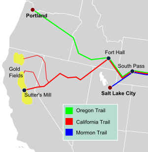
The Applegate Trail was an important path used by pioneers in the mid-1800s. It stretched across parts of what are now the U.S. states of Idaho, Nevada, California, and Oregon. People used this trail to travel west and settle new lands. It was created to be a safer way to reach the Oregon Territory than the main Oregon Trail, which could be very dangerous. A lot of the Applegate Trail followed the same route as the California Trail.
Contents
Why the Applegate Trail Was Needed
In 1843, the Applegate family from Missouri decided to move west. They traveled along the Oregon Trail to the Oregon Country. The brothers Charles, Jesse, and Lindsay led their families. They faced many difficulties on their journey. For example, they lost two children while traveling down the Columbia River.
These tough experiences made the Applegate family want to find a better way. They hoped to find an easier and safer route to the Willamette Valley in Oregon.
Finding the New Route
In 1846, the government of the Oregon Provisional Legislature allowed the Applegates and others to search for a new southern route to Oregon. The group began their journey on June 25, 1846.
The survey team included Jesse Applegate, Lindsay Applegate, David Goff, John Owen, B. F. Burch, W. Sportsman, Robert Smith, a Mr. Goodhue, J. Jones, B. Ausbuan, and Levi Scott. They started from La Creole, Oregon. The team spent three and a half months exploring a path to Fort Hall in present-day Idaho. This is where the Applegate Trail separated from the main Oregon Trail.
On their way back, the group guided about 150 immigrants along this new southern route. This path was also known as the South Road, South Emigrant Trail, or the Scott-Applegate Trail.
The Trail's Path
From Fort Hall, the Applegate Trail headed south. It followed the Humboldt River before going through the Black Rock Desert in present-day Nevada. The trail then entered Northern California. It passed by Goose Lake and Tule Lake.
After crossing the Lost River, the route went through the Klamath Basin. It then crossed the Cascade Range into Southern Oregon. The trail followed Keene Creek to the Siskiyou Mountains. Then it went along Bear Creek and the Rogue River. Heading north from there, the route crossed the Umpqua River. Finally, it crossed the Calapooya Mountains into the southern Willamette Valley.
Later Years of the Trail
Quick facts for kids |
|
|
Applegate-Lassen Trail
|
|
| Location | Rye Patch NW to California state line |
|---|---|
| Part of | Black Rock Desert–High Rock Canyon Emigrant Trails National Conservation Area |
| NRHP reference No. | 78001722 |
| Added to NRHP | December 18, 1978 |
After the first group traveled the trail, it continued to be used. It was also improved over the next few decades. In 1848, news of the California Gold Rush reached the Willamette Valley. Many settlers, including Jesse and Lindsay Applegate, left Oregon to find gold. They used the Applegate Trail to reach northern California.
On August 3, 1992, the Applegate Trail became a National Historic Trail. It is now part of the larger California National Historic Trail. The section of the trail in Nevada is listed on the National Register of Historic Places. It is known there as the Applegate-Lassen Trail.
See also
 In Spanish: Applegate Trail para niños
 | James B. Knighten |
 | Azellia White |
 | Willa Brown |


