
Humboldt River facts for kids
Quick facts for kids Humboldt River |
|
|---|---|

The Humboldt River, flowing through Carlin Canyon
|
|

Map of the Humboldt River watershed
|
|
| Country | United States |
| State | Nevada |
| Physical characteristics | |
| Main source | Humboldt Wells East Humboldt Range, Elko County, Nevada 5,620 ft (1,710 m) 41°7′13″N 114°58′5″W / 41.12028°N 114.96806°W |
| River mouth | Humboldt Sink Churchill County, Nevada 3,894 ft (1,187 m) 39°59′17″N 118°36′4″W / 39.98806°N 118.60111°W |
| Length | 290 mi (470 km) |
| Basin features | |
| Basin size | 16,680 sq mi (43,200 km2) |
| Reference #: | 22 |
The Humboldt River is a long river system in north-central Nevada, USA. It flows generally from east to west. The river starts in the Jarbidge Mountains, Independence Mountains, and Ruby Mountains in Elko County. It ends about 225 miles (362 km) away in the Humboldt Sink in Churchill County.
The Humboldt River is about 290 miles (470 km) long. However, because it twists and turns a lot, its actual length is closer to 380 miles (612 km). It is part of the Great Basin Watershed. This watershed is a large area where rivers and streams flow inward, not to the ocean. The Humboldt River is the third longest river in this watershed.
The area drained by the Humboldt River is called its basin. This basin is the largest part of the Great Basin, covering 16,840 square miles (43,615 km2). The Humboldt River is the only major river system that is entirely within the state of Nevada.
This river has always been an important route for travel across the Great Basin. Many people moving west used it. Today, two major railroad lines and Interstate 80 follow the river's path. The river is named after Alexander von Humboldt, a famous German scientist.
Contents
Humboldt River History

Long ago, the northern Nevada area around the river was home to Numic-speaking people. European settlers did not know much about this region until the early 1800s. That's when fur trappers arrived.
First European Sightings
The first time a European saw the river was on November 9, 1828. This was Peter Skene Ogden from the Hudson's Bay Company. He was on an expedition and found the main river near Winnemucca. Ogden explored hundreds of miles of the river. He made the first map of the area.
Ogden gave the river several names. First, he called it "Unknown River." Then, he named it "Paul's River" after a trapper who died. Later, he called it "Mary's River," after a Native American woman. This name sometimes became "St. Mary's River." In 1833, another group of explorers called it "Barren River." By the 1840s, many travelers knew it as "Ogden's River."
 Palisades Canyon and the Humboldt River in 1868, during the building of the Transcontinental Railroad.
 The same spot near Palisade, 140 years later.
|
Important Trails and Routes
In 1841, the river became part of the California Trail. This trail was the main route for people heading to the California Gold Rush to find gold. In 1845, John C. Frémont explored the river. He made a detailed map and gave it the name "Humboldt River."
Later, in 1869, the river's path was used to build the Central Pacific Railroad. This was part of the Transcontinental Railroad. In the 1900s, U.S. Route 40 followed the river valley. This was later replaced by Interstate 80.
Humboldt River Course

The Humboldt River can be split into three parts: upper, middle, and lower. These parts are based on narrow spots in the valley called Palisade Canyon and Emigrant Canyon.
- The upper basin is in northeastern Nevada. It drains about 5,000 square miles (13,000 km2) of land.
- The middle basin is between Palisade and Emigrant Canyon. It drains about 7,800 square miles (20,000 km2).
- The lower basin is below Emigrant Canyon. It covers about 4,100 square miles (11,000 km2) and includes the Humboldt Sink.
The river's main source is a spring called Humboldt Wells. It is located at the northern end of the East Humboldt Range, near Wells. The river flows west-southwest through Elko County. It passes cities like Elko and Carlin.
Many smaller rivers and creeks flow into the Humboldt River. Some important ones are the North Fork Humboldt River, South Fork Humboldt River, Marys River, Maggie Creek, and Little Humboldt River.
The river then flows through Pershing County. Here, the Rye Patch Dam creates the Rye Patch Reservoir. This reservoir holds water to help grow crops near Lovelock. Finally, the Humboldt River flows into an intermittent lake in the Humboldt Sink. This lake is sometimes dry.
Water Flow
Most of the Humboldt River's water comes from snowmelt in the mountains. These mountains include the Ruby Mountains, Jarbidge Mountains, and Independence Mountains. The amount of water in the river changes a lot. It is highest in spring when snow melts. It also changes from year to year, depending on how much snow falls in winter.
Humboldt River Wildlife
The Humboldt River basin is home to special animals.
Lahontan Cutthroat Trout
The Lahontan cutthroat trout (Oncorhynchus clarki henshawi) is a type of fish. It lives only in northern Nevada, eastern California, and southern Oregon. In 1970, this trout was listed as "endangered," meaning it was at risk of disappearing. Later, it was reclassified as "threatened" to help manage its population. Scientists have found that the Lahontan cutthroat trout in the Humboldt River Basin are a unique type of this fish.
North American Beaver
North American beaver (Castor canadensis) are making a comeback in Elko County. This might be because fewer beavers are being trapped. Also, cattle are eating less of the plants near the river.
Beavers build dams, which are like small walls across the water. These dams help the river in many ways:
- They slow down the water.
- They collect sediment, which is dirt and small rocks.
- They help grow more plants along the riverbanks.
- They raise the water level underground.
For example, on Maggie Creek, a tributary of the Humboldt River, the number of beaver dams grew from 107 in 2006 to 271 in 2010. This has helped the creek flow more steadily all year. It also provides more water for wildlife and farm animals.
Images for kids
-
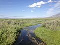
Source of the Humboldt River in Wells
-
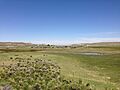
The Humboldt River near Deeth
-
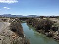
The Humboldt flows through the Rye Patch Reservoir
-
Humboldt River near Lovelock

_in_Deeth,_Nevada.JPG)


See also
 In Spanish: Río Humboldt para niños
