
Pershing County, Nevada facts for kids
Quick facts for kids
Pershing County
|
||
|---|---|---|

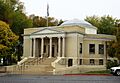
Pershing County Courthouse in Lovelock
|
||
|
||

Location within the U.S. state of Nevada
|
||
 Nevada's location within the U.S. |
||
| Country | ||
| State | ||
| Founded | 1919 | |
| Named for | John J. Pershing | |
| Seat | Lovelock | |
| Largest city | Lovelock | |
| Area | ||
| • Total | 6,067 sq mi (15,710 km2) | |
| • Land | 6,037 sq mi (15,640 km2) | |
| • Water | 31 sq mi (80 km2) 0.5% | |
| Population
(2020)
|
||
| • Total | 6,650 | |
| • Density | 1.0961/sq mi (0.4232/km2) | |
| Time zone | UTC−8 (Pacific) | |
| • Summer (DST) | UTC−7 (PDT) | |
| Congressional district | 2nd | |

Pershing County is a county in the U.S. state of Nevada. In 2020, about 6,650 people lived there. The main town, called the county seat, is Lovelock. You can find a special historical marker for the county at the courthouse in Lovelock.
Part of the famous Black Rock Desert, where the Burning Man event happens, is also in Pershing County.
Contents
A Look Back: Pershing County's History
Pershing County got its name from a famous army general, John J. Pershing. He lived from 1860 to 1948. The county was created in 1919. It was formed from a part of Humboldt County. Pershing County is the newest county to be set up in Nevada.
Where is Pershing County?
According to the U.S. Census Bureau, Pershing County covers a total area of about 6,067 square miles. Most of this area, about 6,037 square miles, is land. The rest, about 31 square miles, is water. This means only a small part (0.5%) of the county is water.
The tallest mountain in Pershing County is Star Peak. It stands tall at 9,840 feet (2,999 meters).
Main Roads and Highways
Many important roads run through Pershing County. These roads help people travel and connect different towns.
 Interstate 80
 Interstate 80 Business (Lovelock)
 U.S. Route 95
U.S. Route 95 Business (Lovelock) State Route 396
 State Route 397
 State Route 398
 State Route 399
 State Route 400
 State Route 401
 State Route 854
 State Route 856
 State Route 860
Neighboring Counties
Pershing County shares its borders with several other counties in Nevada.
- Washoe County – to the west
- Humboldt County – to the north
- Lander County – to the east
- Churchill County – to the south
Protected Natural Areas
Part of the Black Rock Desert-High Rock Canyon Emigrant Trails National Conservation Area is located within Pershing County. This area helps protect important natural and historical sites.
Who Lives in Pershing County?
| Historical population | |||
|---|---|---|---|
| Census | Pop. | %± | |
| 1920 | 2,803 | — | |
| 1930 | 2,652 | −5.4% | |
| 1940 | 2,713 | 2.3% | |
| 1950 | 3,103 | 14.4% | |
| 1960 | 3,199 | 3.1% | |
| 1970 | 2,670 | −16.5% | |
| 1980 | 3,408 | 27.6% | |
| 1990 | 4,336 | 27.2% | |
| 2000 | 6,693 | 54.4% | |
| 2010 | 6,753 | 0.9% | |
| 2020 | 6,650 | −1.5% | |
| 2023 (est.) | 6,364 | −5.8% | |
| U.S. Decennial Census 1790-1960 1900-1990 1990-2000 2010-2018 |
|||
In 2010, about 6,753 people lived in Pershing County. There were 2,018 households, which are groups of people living together. About 1,375 of these were families. The county had about 1.1 people per square mile.
Most people (81.9%) were white. Other groups included Black or African American (3.7%), American Indian (3.2%), and Asian (1.3%). About 22.3% of the people were of Hispanic or Latino background. Many residents had ancestors from Germany (19.5%), Ireland (16.8%), or England (13.8%).
About 31.6% of households had children under 18 living with them. The average age of people in the county was 41 years old. The average household had 2.51 people.
The typical income for a household was about $56,491 per year. For families, it was about $61,410. About 13.7% of all people in the county lived below the poverty line. This included 23.0% of those under 18.
Towns and Communities
Pershing County has one main city and several smaller communities. Some of these smaller places are now ghost towns, meaning very few or no people live there anymore.
City
- Lovelock (This is the county seat, the main town)
- Black Rock City (This is a temporary city built each year for the Burning Man event)
Census-Designated Places
These are areas that are like towns but are not officially incorporated as cities.
- Grass Valley
- Humboldt River Ranch
- Imlay
- Unionville
Unincorporated Communities
These are small settlements that do not have their own local government. Many of them are now ghost towns.
- Dun Glen/Chafey
- Etna
- Humboldt City
- Mazuma
- Mill City
- Rochester
- Scossa
- Seven Troughs
- Star City
- Vernon
Images for kids
-
Pershing County Courthouse in Lovelock
See also
 In Spanish: Condado de Pershing para niños
