Lander County, Nevada facts for kids
Quick facts for kids
Lander County
|
||
|---|---|---|

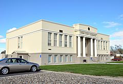
Lander County Courthouse in Battle Mountain
|
||
|
||

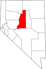
Location within the U.S. state of Nevada
|
||
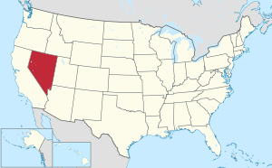
 Nevada's location within the U.S. |
||
| Country | ||
| State | ||
| Founded | 1862 | |
| Named for | Frederick W. Lander | |
| Seat | Battle Mountain | |
| Largest community | Battle Mountain | |
| Area | ||
| • Total | 5,519 sq mi (14,290 km2) | |
| • Land | 5,490 sq mi (14,200 km2) | |
| • Water | 29 sq mi (80 km2) 0.5% | |
| Population
(2020)
|
||
| • Total | 5,734 | |
| • Density | 1.03896/sq mi (0.40114/km2) | |
| Time zone | UTC−8 (Pacific) | |
| • Summer (DST) | UTC−7 (PDT) | |
| Congressional district | 2nd | |
Lander County is a county located in the state of Nevada in the United States. In 2020, about 5,734 people lived there. The main town and county seat is Battle Mountain.
Contents
History of Lander County
Lander County was created in 1862. This happened because many people came to the Reese River area to find gold and silver during a "mining boom." The county was formed along the old Pony Express route. It took parts from Churchill and Humboldt counties.
The county is named after Frederick W. Lander. He was an engineer who helped build a federal wagon road. He also worked with Native American groups in the area. When Nevada became a state in 1864, Lander County was one of its first 11 counties.
The first county seat was Jacob's Spring in 1862. It then moved to Austin in 1863. Finally, in 1979, it moved to Battle Mountain. Lander County is sometimes called the "mother of counties." This is because three other Nevada counties were later formed from its land: Elko, White Pine, and Eureka.
Geography of Lander County

Lander County covers a large area. It has a total area of about 5,519 square miles (14,290 square kilometers). Most of this area, about 5,490 square miles (14,219 square kilometers), is land. Only a small part, about 29 square miles (75 square kilometers), is water.
The highest point in the county is Bunker Hill. It is 11,477 feet (3,498 meters) tall. This mountain is in the Toiyabe Range, close to the border with Nye County. Another important peak is Mount Lewis.
Main Roads in Lander County
Many important roads pass through Lander County. These roads help people travel across the state.
 Interstate 80
 Interstate 80 Business (Battle Mountain)
 U.S. Route 50
 State Route 304
 State Route 305
 State Route 306
 State Route 376
 State Route 722
 State Route 806
Neighboring Counties
Lander County shares its borders with several other counties in Nevada:
- Elko County to the north
- Eureka County to the east
- Nye County to the south
- Churchill County to the west
- Pershing County to the west
- Humboldt County to the northwest
Protected Natural Areas
Part of the Toiyabe National Forest is located within Lander County. This is a protected area where nature is preserved.
People and Population
| Historical population | |||
|---|---|---|---|
| Census | Pop. | %± | |
| 1870 | 2,815 | — | |
| 1880 | 3,624 | 28.7% | |
| 1890 | 2,266 | −37.5% | |
| 1900 | 1,534 | −32.3% | |
| 1910 | 1,786 | 16.4% | |
| 1920 | 1,484 | −16.9% | |
| 1930 | 1,714 | 15.5% | |
| 1940 | 1,745 | 1.8% | |
| 1950 | 1,850 | 6.0% | |
| 1960 | 1,566 | −15.4% | |
| 1970 | 2,666 | 70.2% | |
| 1980 | 4,076 | 52.9% | |
| 1990 | 6,266 | 53.7% | |
| 2000 | 5,794 | −7.5% | |
| 2010 | 5,775 | −0.3% | |
| 2020 | 5,734 | −0.7% | |
| 2023 (est.) | 5,769 | −0.1% | |
| U.S. Decennial Census 1790-1960 1900-1990 1990-2000 2010-2018 |
|||
In 2010, there were 5,775 people living in Lander County. These people lived in 2,213 homes. About 1,545 of these were families. The population density was about 1.1 people per square mile.
Most people in the county (84%) were white. About 4.2% were American Indian. People of Hispanic or Latino origin made up 21.1% of the population. The average age of people in Lander County was 37.1 years old.
Communities in Lander County
Lander County does not have any "incorporated communities." This means there are no cities or towns with their own local governments. However, there are several places where people live.
Towns and Places
These places are called "census-designated places." This means they are areas identified for census purposes.
- Austin
- Battle Mountain (This is the county seat, the main town for county government.)
- Kingston
There is also one "unincorporated community":
Ghost Towns
Lander County also has some interesting ghost towns. These are towns that used to be busy but are now mostly empty.
- Clifton
- Galena
See also
 In Spanish: Condado de Lander para niños
 | Audre Lorde |
 | John Berry Meachum |
 | Ferdinand Lee Barnett |


