Eureka County, Nevada facts for kids
Quick facts for kids
Eureka County
|
|
|---|---|

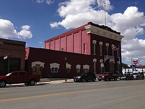
Eureka County Court House
|
|

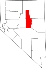
Location within the U.S. state of Nevada
|
|
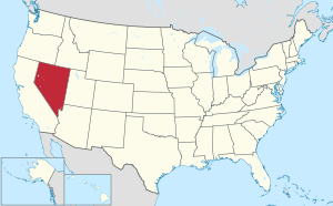
 Nevada's location within the U.S. |
|
| Country | |
| State | |
| Founded | 1873 |
| Named for | Eureka |
| Seat | Eureka |
| Largest community | Crescent Valley |
| Area | |
| • Total | 4,180 sq mi (10,800 km2) |
| • Land | 4,176 sq mi (10,820 km2) |
| • Water | 4.3 sq mi (11 km2) 0.1% |
| Population
(2020)
|
|
| • Total | 1,855 |
| • Density | 0.4438/sq mi (0.17134/km2) |
| Time zone | UTC−8 (Pacific) |
| • Summer (DST) | UTC−7 (PDT) |
| Congressional district | 2nd |
Eureka County is a county in the state of Nevada, USA. As of 2020, about 1,855 people lived there. This makes it the second-least populated county in Nevada. The main town and county seat is Eureka.
Eureka County is also part of the Elko area.
Contents
History of Eureka County
Eureka County was created in 1873. It was formed from parts of Lander County. This happened after people found a lot of silver more than 100 miles (160 km) east of Austin.
The miners in the new camp complained that Austin was too far away. They needed a closer place for official county business. So, a new county was made just for them.
The county got its name from the ancient Greek word "Eureka". This word means "I have found it!" It's a famous saying used when someone discovers something important. Eureka has always been the main town for the county.
Geography of Eureka County

Eureka County covers a large area. It is about 4,180 square miles (10,826 square kilometers) in total. Most of this area is land, with only a small amount of water.
The highest point in the county is Diamond Peak. It stands at 10,631 feet (3,240 meters) tall. This peak is in the Diamond Mountains. It sits right on the border with White Pine County.
Counties Nearby
Eureka County shares borders with these other counties:
- Elko County - to the northeast
- White Pine County - to the east
- Nye County - to the south
- Lander County - to the west
Protected Natural Areas
Part of the Humboldt-Toiyabe National Forest is located in Eureka County. This is a large protected area.
Main Roads
Several important roads pass through Eureka County:
 Interstate 80
 U.S. Route 50
 State Route 278
 State Route 306
 State Route 766
 State Route 781
Population Changes
| Historical population | |||
|---|---|---|---|
| Census | Pop. | %± | |
| 1880 | 7,086 | — | |
| 1890 | 3,275 | −53.8% | |
| 1900 | 1,954 | −40.3% | |
| 1910 | 1,830 | −6.3% | |
| 1920 | 1,350 | −26.2% | |
| 1930 | 1,333 | −1.3% | |
| 1940 | 1,361 | 2.1% | |
| 1950 | 896 | −34.2% | |
| 1960 | 767 | −14.4% | |
| 1970 | 948 | 23.6% | |
| 1980 | 1,198 | 26.4% | |
| 1990 | 1,547 | 29.1% | |
| 2000 | 1,651 | 6.7% | |
| 2010 | 1,987 | 20.4% | |
| 2020 | 1,855 | −6.6% | |
| 2023 (est.) | 1,917 | −3.5% | |
| U.S. Decennial Census 1790-1960 1900-1990 1990-2000 2010-2018 |
|||
In 2010, there were 1,987 people living in Eureka County. The population density was about 0.5 people per square mile. The average age of people living there was 42.4 years old.
Towns and Communities
There are no officially incorporated cities or towns in Eureka County.
Main Communities
These are places where people live, but they are not official cities:
- Crescent Valley
- Eureka (This is the county seat, the main town for county government)
Other Small Communities
Old Ghost Towns
Some places in Eureka County used to be towns but are now empty:
- Alpha
- Ruby Hill
Education in Eureka County
The Eureka County School District is in charge of all the public schools in the county.
See also
 In Spanish: Condado de Eureka para niños
 | William Lucy |
 | Charles Hayes |
 | Cleveland Robinson |

