
Diamond Mountains (Nevada) facts for kids
Quick facts for kids Diamond Mountains |
|
|---|---|

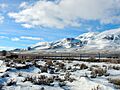
Distant view of Diamond Peak, highest point in the range
|
|
| Highest point | |
| Peak | Diamond Peak |
| Elevation | 10,631 ft (3,240 m) |
| Geography | |

Location in Nevada
|
|
| Country | United States |
| State | Nevada |
| Counties | White Pine, Eureka |
| Range coordinates | 39°53′18″N 115°48′15″W / 39.8883°N 115.8042°W |
| Topo map | USGS Diamond Springs |
The Diamond Mountains are a cool mountain range found in northern Nevada, in the Western United States. They sit right on the border between Eureka and White Pine Counties. Imagine a giant natural wall separating two areas – that's what these mountains do!
Exploring the Diamond Mountains
These mountains are a big part of Nevada's landscape. They are home to interesting plants and animals. Let's learn more about what makes them special.
Where are the Diamond Mountains located?
The Diamond Mountains are in the central part of Nevada. They act like a natural barrier. They separate two important valleys: Newark Valley and Diamond Valley. Think of them as a giant divider between these two flat areas.
How tall are the Diamond Mountains?
The highest point in the Diamond Mountains is a peak called Diamond Peak. It stands super tall at 10,631 feet (about 3,240 meters) above sea level! That's higher than many clouds you see. The entire mountain range covers a large area of about 293.4 square miles.
What's around the Diamond Mountains?
To the southeast, the Diamond Mountains connect with other mountain ranges. They meet the Fish Creek Range and the Mountain Boy Range. It's like a family of mountains all connected together.
What kind of nature lives here?
The plants and animals in the Diamond Mountains are typical for high places in the Central Basin and Range ecoregion. This means you might see plants that can handle dry weather and animals that are used to living in rocky, open areas. Think of tough desert plants and animals like deer, rabbits, and various birds.
Visiting the Diamond Mountains
Even though these mountains are in a wild area, there are ways to visit them. People can explore parts of the range using roads.
How can you get to the mountains?
The town of Eureka is located near the Diamond Mountains. From Eureka, you can find unpaved roads that lead north. These roads help people get to the western side of the mountain range.
What about major roads?
If you travel southeast from Eureka, you'll find U.S. 50. This major highway crosses the southern part of the Diamond Mountains. It then turns east at the very end of the range.
Are there other routes?
Yes, Nevada State Route 892 runs along the eastern side of the mountains. It follows the foothills for about half the length of the range. After that, the road becomes unpaved. It continues north through Huntington Valley and eventually connects with Nevada State Route 228 and the city of Elko. These roads help people explore the beautiful landscapes around the Diamond Mountains.
Images for kids
-
Diamond Mountains, winter 2013

