
Great Basin Desert facts for kids
Quick facts for kids Central Basin and RangeGreat Basin shrub steppe |
|
|---|---|

Central Basin and Range from space
(central-west Nevada region, view due-south) |
|

The Great Basin Desert, as marked on a map by the USGS
|
|
| Ecology | |
| Realm | Nearctic |
| Biome | Deserts and xeric shrublands |
| Borders | Northern Basin and Range (ecoregion) (80), Sierra Nevada (ecoregion) (5) and Wasatch and Uinta Mountains (ecoregion) (19) |
| Bird species | 204 |
| Mammal species | 105 |
| Geography | |
| Country | United States |
| States | Nevada, Utah, California, Idaho and Oregon |
| Climate type | Cold desert and cold semi-arid |
| Conservation | |
| Habitat loss | 90% |
| Protected | 76.62% |
The Great Basin Desert is a huge, dry area located between the Sierra Nevada mountains and the Wasatch Range. It's a special kind of desert called a "temperate desert." This means it has hot, dry summers and cold, snowy winters.
This desert covers a big part of Nevada. It also stretches into parts of Utah, California, and Idaho. The Great Basin Desert is one of only four deserts in North America. The others are the Mojave, Sonoran, and Chihuahuan Deserts.
The desert has a unique landscape with wide valleys and long mountain ranges. These mountains usually run north to south. Many peaks in the desert are taller than 3,000 meters (about 9,800 feet). Even the valleys are high, mostly above 1,200 meters (about 3,900 feet).
Life in the Great Basin Desert changes a lot depending on how high up you go. You can find different plants and animals from the low, salty dry lakes to the rolling sagebrush valleys. Higher up, there are even pinyon-juniper forests. This big difference in height creates many unique homes for plants and animals. This has led to many small groups of species that are found only in certain areas.
More than 600 types of vertebrates (animals with backbones) live here. Sadly, 63 of these species are now a concern for scientists. This is because their natural homes are shrinking. Some examples are the Greater sage-grouse, Kit fox, Ord's kangaroo rat, and Desert horned lizard.
The desert's environment also changes from one place to another. Its high elevation and location between mountain ranges affect the weather. The Sierra Nevada mountains block moisture from the Pacific Ocean. This creates a "rain shadow" effect. The Rocky Mountains also block moisture from the Gulf of Mexico. Because of these rain shadows, different parts of the desert get different amounts of rain.
Ancient lakes from the last ice age, like Lake Lahontan and Lake Bonneville, also shaped the desert. When these lakes dried up, they left behind different amounts of salt and other minerals in the soil.
Contents
- What is the Great Basin Desert?
- What is the Climate Like?
- Life Zones of the Great Basin Desert
- Subregions of the Great Basin Desert
- Salt Deserts
- Shadscale-Dominated Saline Basins
- Lahontan and Tonopah Playas
- Lahontan Salt Shrub Basin
- Lahontan Sagebrush Slopes
- Lahontan Uplands
- Upper Humboldt Plain
- Carbonate Sagebrush Valleys
- Central Nevada High Valleys
- Central Nevada Mid-Slope Woodland and Brushland
- Central Nevada Bald Mountains
- Tonopah Basin
- Endangered Species
- Images for kids
- See also
What is the Great Basin Desert?

The Great Basin Desert is known for its special animals and plants. But its exact borders can be a bit tricky to define.
Scientists have different ways to describe the Great Basin Desert. Sometimes, they define it by what it doesn't have. For example, some say it's the desert area that doesn't have the creosote bush. This plant is common in other deserts.
The Great Basin Desert includes many dry areas without creosote bush. These include valleys like Chalfant, Hammil, Benton, and Queen valleys. However, some nearby valleys like Panamint, Saline, and Eureka do have creosote bush.
Scientists also use "ecoregions" to define areas. An ecoregion is a large area with similar ecosystems. The Great Basin Desert largely matches the "Central Basin and Range" ecoregion. It also overlaps with the "Great Basin Shrub Steppe" ecoregion. These names describe the type of plants and landforms found there.
This article talks about the general nature of this region, including its high mountains. If you want to learn more about the high-elevation areas, you can look at the Great Basin montane forests article.
What is the Climate Like?

The Great Basin Desert has extreme weather. Summers are hot and dry, while winters are cold and snowy. You can find freezing mountain ridges and warm, windy valleys. Temperatures can drop by 30 degrees Fahrenheit (about 17 degrees Celsius) from day to night. This is what we call a "high desert" climate.
The Sierra Nevada mountains in eastern California cause the desert's dry climate. These mountains are very tall, reaching 14,000 feet (about 4,200 meters). As weather systems from the Pacific Ocean try to cross them, the air is forced upwards. This causes the moisture to fall as rain and snow on the mountain's western side. By the time the air reaches the desert on the eastern side, there's very little moisture left. This is called a rain shadow.
The rain shadow effect is stronger closer to the Sierra Nevada. The western part of the desert gets about 9 inches (228 mm) of rain each year. The eastern part gets a bit more, around 12 inches (304 mm). Most rain and snow falls in the higher parts of the mountains.
Any water that falls in the Great Basin Desert doesn't flow to the Atlantic Ocean or the Pacific Ocean. Instead, it drains into temporary or salty lakes. Or it simply evaporates or soaks into the ground. This desert is the coldest of all the deserts in North America.
Weather in the Great Basin Desert can change a lot in one day. Since it's very mountainous, temperatures vary with height. For every 1,000 feet (300 meters) you go up, the temperature drops by about 3.6 degrees Fahrenheit (2 degrees Celsius). This means mountain tops can be much colder than valleys at the same time. Strong winds are also common on mountain tops.
This dry climate and rugged land are tough for many plants and animals. But over time, many species have adapted to these conditions. This has led to a good number of different species living in the area.
Great Basin National Park is a good example of the desert's typical climate.
| Climate data for Great Basin National Park - Lehman Caves Visitor Center (elevation 6,840 feet (2,080 m)) | |||||||||||||
|---|---|---|---|---|---|---|---|---|---|---|---|---|---|
| Month | Jan | Feb | Mar | Apr | May | Jun | Jul | Aug | Sep | Oct | Nov | Dec | Year |
| Record high °F (°C) | 67 (19) |
66 (19) |
74 (23) |
81 (27) |
6 (−14) |
14 (−10) |
32 (0) |
32 (0) |
10 (−12) |
6 (−14) |
−12 (−24) |
−19 (−28) |
−20 (−29) |
| Mean daily maximum °F (°C) | 40.5 (4.7) |
42.8 (6.0) |
48.7 (9.3) |
56.7 (13.7) |
66.5 (19.2) |
77.4 (25.2) |
85.7 (29.8) |
83.3 (28.5) |
74.5 (23.6) |
61.7 (16.5) |
48.4 (9.1) |
41.1 (5.1) |
60.6 (15.9) |
| Mean daily minimum °F (°C) | 18.9 (−7.3) |
21.2 (−6.0) |
25.5 (−3.6) |
31.5 (−0.3) |
40.0 (4.4) |
49.0 (9.4) |
57.4 (14.1) |
55.8 (13.2) |
47.0 (8.3) |
37.1 (2.8) |
25.9 (−3.4) |
19.6 (−6.9) |
35.7 (2.1) |
| Record low °F (°C) | −20 (−29) |
−15 (−26) |
−2 (−19) |
0 (−18) |
— | — | — | — | — | — | — | — | −20 (−29) |
| Average precipitation inches (mm) | 1.05 (27) |
1.18 (30) |
1.37 (35) |
1.21 (31) |
1.24 (31) |
0.87 (22) |
0.97 (25) |
1.18 (30) |
1.08 (27) |
1.24 (31) |
0.97 (25) |
0.96 (24) |
13.33 (339) |
| Average snowfall inches (cm) | 12.8 (33) |
13.8 (35) |
13.2 (34) |
7.1 (18) |
2.1 (5.3) |
0.2 (0.51) |
0 (0) |
0 (0) |
0.2 (0.51) |
3.7 (9.4) |
8.7 (22) |
10.7 (27) |
72.6 (184) |
Fallon has a climate typical of lower, western parts of the desert. It doesn't get much rain, and summers are hot. But temperatures are not as extreme as in the Mojave or Sonoran deserts. This is because Fallon is higher up and further north. Winters are still cold here.
| Climate data for Fallon, Nevada. (Elevation 3,960 feet (1,210 m)) | |||||||||||||
|---|---|---|---|---|---|---|---|---|---|---|---|---|---|
| Month | Jan | Feb | Mar | Apr | May | Jun | Jul | Aug | Sep | Oct | Nov | Dec | Year |
| Record high °F (°C) | 71 (22) |
78 (26) |
84 (29) |
90 (32) |
20 (−7) |
27 (−3) |
35 (2) |
33 (1) |
21 (−6) |
12 (−11) |
0 (−18) |
−21 (−29) |
−27 (−33) |
| Mean daily maximum °F (°C) | 44.3 (6.8) |
51.3 (10.7) |
58.9 (14.9) |
65.9 (18.8) |
73.9 (23.3) |
83.1 (28.4) |
92.2 (33.4) |
90.1 (32.3) |
81.1 (27.3) |
69.2 (20.7) |
55.4 (13.0) |
45.4 (7.4) |
67.6 (19.8) |
| Mean daily minimum °F (°C) | 18.1 (−7.7) |
23.2 (−4.9) |
27.8 (−2.3) |
33.9 (1.1) |
41.4 (5.2) |
47.9 (8.8) |
54.0 (12.2) |
51.4 (10.8) |
43.2 (6.2) |
33.8 (1.0) |
24.8 (−4.0) |
18.9 (−7.3) |
34.9 (1.6) |
| Record low °F (°C) | −25 (−32) |
−27 (−33) |
1 (−17) |
13 (−11) |
— | — | — | — | — | — | — | — | −27 (−33) |
| Average precipitation inches (mm) | 0.54 (14) |
0.54 (14) |
0.46 (12) |
0.51 (13) |
0.60 (15) |
0.43 (11) |
0.16 (4.1) |
0.22 (5.6) |
0.28 (7.1) |
0.41 (10) |
0.38 (9.7) |
0.48 (12) |
4.98 (126) |
| Average snowfall inches (cm) | 1.8 (4.6) |
0.9 (2.3) |
0.8 (2.0) |
0.2 (0.51) |
0.1 (0.25) |
0 (0) |
0 (0) |
0 (0) |
0 (0) |
0.1 (0.25) |
0.5 (1.3) |
1.3 (3.3) |
5.7 (14) |
| Source: The Western Regional Climate Center | |||||||||||||
The Great Salt Lake Desert is in the northeast part of the Great Basin Desert. It's a great example of a cold desert climate. This area gets more rain than similar dry lakebeds in the western part of the desert.
| Climate data for Knolls, Great Salt Lake Desert, Utah. (Elevation 4,250 feet (1,300 m)) | |||||||||||||
|---|---|---|---|---|---|---|---|---|---|---|---|---|---|
| Month | Jan | Feb | Mar | Apr | May | Jun | Jul | Aug | Sep | Oct | Nov | Dec | Year |
| Record high °F (°C) | 63 (17) |
63 (17) |
79 (26) |
14 (−10) |
24 (−4) |
35 (2) |
43 (6) |
39 (4) |
25 (−4) |
8 (−13) |
−3 (−19) |
−25 (−32) |
−25 (−32) |
| Mean daily maximum °F (°C) | 36.5 (2.5) |
41.4 (5.2) |
54.4 (12.4) |
62.3 (16.8) |
72.3 (22.4) |
83.5 (28.6) |
92.8 (33.8) |
90.9 (32.7) |
80.0 (26.7) |
64.3 (17.9) |
46.5 (8.1) |
36.5 (2.5) |
63.4 (17.4) |
| Mean daily minimum °F (°C) | 16.9 (−8.4) |
19.3 (−7.1) |
29.1 (−1.6) |
36.6 (2.6) |
44.9 (7.2) |
54.7 (12.6) |
62.1 (16.7) |
59.5 (15.3) |
48.0 (8.9) |
34.4 (1.3) |
23.3 (−4.8) |
14.5 (−9.7) |
37.0 (2.8) |
| Record low °F (°C) | −16 (−27) |
−17 (−27) |
−1 (−18) |
— | — | — | — | — | — | — | — | — | −17 (−27) |
| Average precipitation inches (mm) | 0.61 (15) |
0.46 (12) |
0.91 (23) |
1.01 (26) |
1.23 (31) |
0.68 (17) |
0.36 (9.1) |
0.31 (7.9) |
0.56 (14) |
0.77 (20) |
0.61 (15) |
0.38 (9.7) |
7.88 (200) |
| Average snowfall inches (cm) | 0.3 (0.76) |
0.1 (0.25) |
0 (0) |
0 (0) |
0 (0) |
0 (0) |
0 (0) |
0 (0) |
0 (0) |
0 (0) |
0 (0) |
0.1 (0.25) |
0.5 (1.3) |
| Source: The Western Regional Climate Center | |||||||||||||
Life Zones of the Great Basin Desert
The Great Basin Desert has many different types of plants and animals. This is because of its unique "basin and range" shape. The climate, elevation, and soil type all affect where different plants and animals live.
As you go from the low valleys to the high mountain peaks, you'll see many changes. There are about 200 different plant and animal groups. These groups can be put into six main "life zones."
Shadscale Zone

The lowest parts of the valleys are called the shadscale zone. Here, water from the mountains evaporates, leaving salty soil. Plants in this area are very good at living with little rain, high heat, and salty conditions.
Some areas, called playas, are very dry and sometimes flood. On the edges of these playas, shadscale is the main plant. Other plants like iodine bush, saltgrass, and winterfat also grow here. You won't find any trees in this zone.
Big greasewood grows in very salty areas or where the water is close to the surface. These plants produce many small seeds. Rodents and insects like to eat these seeds. The salty soil and lack of water make it hard to grow crops here.
Sagebrush Zone

As you go up in elevation, the soil becomes less salty and has more moisture. This leads to the sagebrush zone. This is the largest part of the desert, covering almost 40% of the land. It's mostly covered by big sagebrush plants.
The sagebrush zone is found on the lower mountain slopes. Areas with wetter, less salty soil have lots of big sagebrush. Other types like low sagebrush grow on rocky slopes.
In the past, native grasses grew among the sagebrush. But now, plants like cheatgrass are common. Wildfires and too much animal grazing have changed this zone. Other shrubs like rabbitbrush, bitterbrush, and Mormon tea also grow here.
Pinyon-Juniper Community

Higher up, you'll find the pinyon-juniper community. The main trees here are singleleaf pinyon pine and Utah juniper. They often grow with sagebrush and bitterbrush underneath.
This zone is usually between 6,000 and 8,000 feet (1,800 to 2,400 meters) high. These evergreen trees are short, rarely growing over 20 feet (6 meters) tall. This dense area of trees is important for many animals. For example, Palmer's chipmunk relies on this habitat.
The trees are spread out, with shrubs and other plants growing below them. This is why some scientists call it the "pygmy forest." Lower parts of this zone have more juniper. The middle has both pinyon and juniper. The highest parts have mostly pinyon pines.
Montane Community
The tallest mountains in the Great Basin Desert have a montane community. These mountain forests are very different from one another. This is because they are separated by large desert valleys. Also, the types of rocks and local weather vary greatly.

Because these mountain communities are isolated, they have their own long histories. Each one has been affected differently by how plants and animals spread across the desert. Smaller communities are also at risk from climate change and genetic changes.
You can find white fir, Douglas fir, and ponderosa pine trees in the middle elevations of some mountains. Higher up, you'll see limber pine, subalpine fir, Engelmann spruce, and bristlecone pines. These trees grow up to the treeline. Mountain mahogany often grows on drier, warmer slopes. You can also find pure stands of aspen trees here.
The bristlecone pine is a very important tree in the Great Basin Desert. These trees can live for thousands of years! They grow in harsh areas where few other plants can survive. This means they have little competition and a lower risk of fire. They grow very slowly, making their wood dense and resistant to disease. All these things help bristlecone pines live for a very long time.
Alpine Community

Some mountains in the Great Basin Desert are so high that they have an alpine community. This is an area of low-growing plants found above the treeline. The treeline is usually above 10,000 feet (3,000 meters) in this desert. It gets lower as you go further north.
The plants that grow above the treeline are separated from other similar areas by miles of valleys. This "island" effect creates many endemic species. These are species that have developed while isolated on a mountain peak. They are found only in that one place. Above the treeline, you'll find grasses, sedges, small herbs, and wildflowers.
Riparian Community

Riparian communities are found along streams and rivers in the Great Basin Desert. They exist at all elevations and across all life zones. In this desert, surface water quickly evaporates or soaks into the ground. But areas around streams have lots of plant life.
Water-loving plants like willow, narrowleaf cottonwood, choke cherry, wild rose, and aspen grow in these wet areas. Willows have roots that spread out to find water. They also help prevent soil from washing away. These plants provide wood for beavers. In these areas, silver buffaloberry often gives shelter to North American porcupines.
Subregions of the Great Basin Desert
The U.S. Environmental Protection Agency (EPA) divides the Central Basin and Range ecoregion into smaller parts called Level IV ecoregions. These describe how the region changes in different places. Some of the low-elevation areas are part of the Great Basin shrub steppe. The high-elevation areas are part of the Great Basin montane forests.
| code | |
|---|---|
| 13a | Salt Deserts |
| 13b | Shadscale-Dominated Saline Basins |
| 13c | Sagebrush Basins and Slopes |
| 13d | Woodland and Shrub-Covered Low Mountains |
| 13e | Carbonate High Elevation Mountains |
| 13f | Moist Wasatch Front Footslopes |
| 13g | Wetlands |
| 13h | Lahontan and Tonopah Playas |
| 13i | Malad and Cache Valleys |
| 13j | Lahontan Salt Shrub Basin |
| 13k | Lahontan Sagebrush Slopes |
| 13l | Lahontan Uplands |
| 13m | Upper Humboldt Plains |
| 13n | Mid-Elevation Ruby Mountains |
| 13o | High Elevation Ruby Mountains |
| 13p | Carbonate Sagebrush Valleys |
| 13q | Carbonate Woodland |
| 13r | Central Nevada High Valleys |
| 13s | Central Nevada Mid-Slope Woodland and Brushland |
| 13t | Central Nevada Bald Mountains |
| 13u | Tonopah Basin |
| 13v | Tonopah Sagebrush Foothills |
| 13w | Tonopah Uplands |
| 13x | Sierra Nevada-Influenced Ranges |
| 13y | Sierra Nevada-Influenced High Elevation Mountains |
| 13z | Upper Lahontan Basin |
| 13aa | Sierra Nevada-Influenced Semiarid Hills and Basins |
| 13ab | Sierra Valley |
| 13ac | Upper Owens Valley |
| 13ad | Mono-Adobe Valleys |
| 13ae | Bishop Volcanic Tableland |
Salt Deserts

The Salt Desert ecoregion has flat areas like playas, salt flats, and mud flats. It also has salty lakes. These areas are common in the Bonneville Basin. They have more salt than other dry lake areas to the west.
The amount of water and salt here changes each year. When it's dry, salt crusts form, and wind blows the salt around. Most plants can't grow here. But some salt-tolerant plants like pickleweed and black greasewood can be found. The soil is not good for farming. This area is used for wildlife, recreation, and military training.
Shadscale-Dominated Saline Basins
This ecoregion is dry, flat, and has no outlet to the ocean. These basins are found in the Bonneville Basin. They are higher up and colder in winter than the Lahontan salt shrub basin to the west.
The soil here is light-colored and has a lot of salt and alkali. It stays dry for long periods. The saltbush plants that grow here can handle extreme temperatures, dryness, and salt. They are tougher than the big sagebrush found at higher elevations.
In Nevada, these basins are smaller and closer to mountains. These mountains have a lot of carbonate rock. This rock allows water to soak through and come out as springs in the valleys. Some isolated valleys even have unique fish species, like the Newark Valley tui chub.
Lahontan and Tonopah Playas

These flat, often barren areas include mudflats, alkali flats, and temporary salty lakes. Examples are the Black Rock Desert and Carson Sink. These are what's left of Pleistocene Lake Lahontan, which was once as big as Lake Erie.
Playas are the lowest points in the Lahontan Basin. Rivers from the Sierra Nevada mountains end here. These playas fill with water from melting snow and rain, creating homes for migratory birds. Black greasewood or four-winged saltbush may grow around the edges. They often help stabilize small sand dunes. This ecoregion is not good for grazing animals. Windblown salt dust from the playas can affect nearby soils and plants. These playas are important for wildlife, recreation (like Burning Man), and military uses.
Lahontan Salt Shrub Basin
This is a large, dry plain that was once covered by ancient Lake Lahontan. The Lahontan Basin is lower and warmer in winter than the Bonneville Basin to the east. Even though it connects to the Mojave Desert in the south, winters are cold enough here to stop Mojave Desert plants from spreading north.
Besides shadscale, other salt-tolerant shrubs like Shockley's desert-thorn and Bailey greasewood cover the lower slopes. These shrubs make the Lahontan salt shrub basin unique from other salty shrub areas in Nevada.
Sand dunes can form where wind blows sand against something. These dunes have special plants and many small mammals. The Carson River and Truckee River, which start in the Sierra Nevada, provide water for farming here. Trees only grow along these rivers.
Lahontan Sagebrush Slopes

This ecoregion has hills, alluvial fans, and low mountains. Their soils are rocky and don't have the fine lake sediments found in lower parts of the Lahontan Basin. As you go higher, there's more moisture and less salt.
The plants change from greasewood-shadscale at the bottom to Wyoming big sagebrush and a unique Lahontan sagebrush at higher elevations. Grasses grow more towards the northeast, where there is more rain.
The low hills and mountains in the Lahontan Basin often have lightning-caused fires in summer. The introduced cheatgrass tends to replace native plants after a fire. This grass also provides more fuel for future fires.
Lahontan Uplands
The Lahontan Uplands are the highest parts of the mountain ranges within the Lahontan salt shrub basin. The slopes are between 6,400 and 8,800 feet (1,950 to 2,680 meters) high. They are covered in sagebrush, grasses, and scattered Utah juniper trees.
Pinyon trees grow with juniper on the Stillwater Range and Fairview Peak. But they are mostly absent from other parts of this ecoregion. Low sagebrush and black sagebrush grow all the way to the mountaintops, even above the tree line.
Cool-season grasses like bluebunch wheatgrass are common in the north. In the south, warm-season grasses like Indian ricegrass take over.
Upper Humboldt Plain

The Upper Humboldt Plains ecoregion has rolling plains with some buttes and low mountains. It's mostly made of volcanic ash and other volcanic rocks. Low sagebrush is common in areas with shallow, stony soil. Cool-season grasses like bluebunch wheatgrass and Idaho fescue also grow here.
This ecoregion is wetter and cooler than other Nevada ecoregions at the same height. It's a transition area to the Northern Basin and Range ecoregion near the Nevada-Oregon border. Like the Lahontan Basin, lightning fires are common. After a fire, cheatgrass often replaces the native grasses and shrubs. Grazing animals is the main land use here. There is some farming near the Humboldt River.
Carbonate Sagebrush Valleys
These valleys and dry uplands surround the carbonate mountains of eastern Nevada. They are made of limestone or dolomite. The combination of summer rain and limestone affects the plants that grow here.
The soil favors shrubs like black sagebrush and winterfat that can handle shallow soil. Even in other soils, roots might be blocked by a hard layer formed by carbonates. Because of this, there are fewer shrubs here compared to other sagebrush areas in Nevada.
The grasses underneath change from cool-season grasses like bluebunch wheatgrass in the north to warm-season grasses like blue grama in the south. Blue grama is a sign of summer rainfall.
Central Nevada High Valleys

The Central Nevada high valleys ecoregion has rolling valleys covered in sagebrush. They are generally over 5,000 feet (1,500 meters) high. Alluvial fans from the surrounding mountains fill these valleys.
Wyoming big sagebrush and grasses are common in flatter areas. Black sagebrush grows on volcanic hills and alluvial fans. This ecoregion has fewer types of species than other sagebrush areas. This is because it's very dry and isolated.
Salty playas can be found on flat areas. These playas have less shadscale and other shrubs than lower, drier ecoregions to the west. Valleys with permanent water have unique fish populations, like the Monitor Valley speckled dace.
Central Nevada Mid-Slope Woodland and Brushland
This ecoregion is found at elevations from 6,500 to 8,000 feet (1,980 to 2,440 meters). However, continuous woodlands are not as common here as in other woodland ecoregions. Pinyon-juniper trees grow sparsely among the shrubs. This is due to past fires, logging, and local weather.
Where woodlands do exist, there are very few different plants growing underneath. This is especially true in areas where the tree canopy is dense. Areas of black and Wyoming big sagebrush gradually change to mountain big sagebrush and curlleaf mountain-mahogany at higher elevations.
Central Nevada Bald Mountains

The Central Nevada Bald Mountains are dry and mostly treeless. Even though they are only about 100 miles (160 km) east of the Sierra Nevada mountains, they don't have Sierra species. This is because of the dry conditions.
These mountains look barren, but they are covered in dense mountain brush. This brush is mostly mountain big sagebrush, serviceberry, and low sagebrush. Scattered groups of curlleaf mountain-mahogany and aspen trees grow in wetter spots.
A few scattered limber or bristlecone pines grow on ranges taller than 10,000 feet (3,000 meters). The Toiyabe Range is high enough to have an alpine zone. But it lacks the right kind of ground to hold snowmelt. These isolated "sky islands" have many rare and unique plant species.
Tonopah Basin
The Tonopah Basin is a transition area between the Great Basin Desert and the warmer Mojave Desert to the south. It shows features of both deserts. The western side is like the Lahontan Basin. The lower, hotter Pahranagat Valley on the east side is more like the Mojave Desert.
Like basins further north, shadscale and other dry-land shrubs cover wide valleys, hills, and alluvial fans. However, here, different shrubs often grow together in diverse patterns. The shrubs have warm-season grasses underneath, like Indian ricegrass and galleta grass.
Valleys with permanent water have unique fish species. These include the Railroad Valley tui chub, Pahranagat roundtail chub, Railroad Valley springfish, and the White River springfish.
Endangered Species
The Great Basin Desert's unique shape, with isolated mountain tops separated by vast desert valleys, makes it vulnerable. Animal and plant groups on high peaks are cut off from each other. This means they can't breed with other groups. Small groups have less genetic variety. This makes them less able to adapt to changes.
Activities like pumping groundwater, building roads and homes, grazing animals, and mining all change habitats. As more habitats are affected, the risk of species disappearing forever increases. The Great Basin Desert is home to many threatened and endangered species:
- Birds
- Least tern (Sterna antillarum athalassos)
- Plants
- Sodaville milkvetch (Astragalas lentiginosus var. sesquimetralis)
- Ute lady's tresses (Spiranthes diluvialis)
- Fish
- Lahontan cutthroat trout (Oncorhynchus clarki henshawi)
- Desert dace (Eremichthys acros)
- White River spinedace (Lepidomeda albivallis)
- Mammals
- Utah prairie dog (Cynomys parvidens)
Images for kids
-
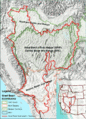
Ecoregions as currently delineated by the Environmental Protection Agency and World Wildlife Fund
-
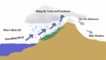
Orographic uplift resulting in a rain shadow as air descends and expands, resulting in arid warming, on the leeward side of a hypothetical mountain.
-
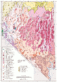
Map of ecoregions in Nevada. Some of the Level IV ecoregions are described in this article.
-
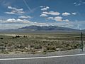
Big Smoky Valley is part of the Tonopah Basin


.jpg)
See also
 In Spanish: Desierto de la Gran Cuenca para niños
