Toiyabe Range facts for kids
Quick facts for kids Toiyabe Range |
|
|---|---|

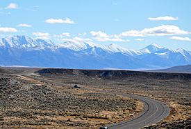
Looking southeast from above State Route 305 north of Austin
|
|
| Highest point | |
| Peak | Arc Dome |
| Elevation | 11,778 ft (3,590 m) |
| Geography | |

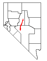
Location of Toiyabe Range in Nevada
|
|
| Country | United States |
| State | Nevada |
| Region | Central Basin and Range ecoregion |
| District | Lander and Nye counties |
| Range coordinates | 39°59′59″N 116°43′03″W / 39.99972°N 116.71750°W |
The Toiyabe Range is a long chain of mountains in Nevada, United States. It stretches across Lander and Nye counties. Most of these mountains are part of the Humboldt-Toiyabe National Forest.
The highest point in the Toiyabe Range is Arc Dome. It stands tall at 11,788 feet (3,592 meters). This area is protected as the Arc Dome Wilderness. Another high point, Bunker Hill, is also found here. The range starts near Tonopah, Nevada and runs north for about 120 miles (190 km). This makes it the second longest mountain range in Nevada!
Contents
Exploring the Toiyabe Mountains
The Toiyabe Range is located in the "rain shadow" of the Sierra Nevada (U.S.) mountains. This means it gets very little rain. Because of this, it's too dry for large forests, except for some scattered pine trees.
Even though it's dry now, the climate was much colder and snowier long ago. During the Pleistocene Ice Age, glaciers formed here. You can still see signs of these ancient glaciers. Look for bowl-shaped hollows called cirques and piles of rock left by glaciers called moraines.
There are many fun hiking trails in the Toiyabe Mountains. One popular trail follows the very top of the mountain range.
Neighboring Mountain Ranges
The Toiyabe Range has other mountain neighbors. To the west, the Reese River Valley separates it from the Shoshone Mountains. To the east, the Big Smoky Valley lies between the Toiyabe Range and the Toquima Range.
Towns and Highways
The historic mining town of Austin is located on the western side of the Toiyabe Range. It's about halfway along the range's length. U.S. Route 50, also known as the "Loneliest Highway in America," passes through Austin. It then crosses the range at Austin Summit, which is 7,484 feet (2,281 meters) high. Another major road, U.S. Route 6, goes south of the range. It connects towns like Tonopah and Ely.
Humboldt-Toiyabe National Forest
The Toiyabe Range is an important part of the Humboldt-Toiyabe National Forest. This forest is managed to protect nature and provide places for people to enjoy the outdoors. The part of the forest that covers the Toiyabe Range is called the Austin Ranger District.
The Toiyabe Crest Trail
One of the most exciting features in the Toiyabe Range is the National Recreation Toiyabe Crest Trail. This amazing trail runs along the top of the mountain ridge for over 70 miles! About 30 miles of the trail go through the Arc Dome Wilderness.
The Army Corps of Engineers built this trail in the 1930s. They also built many "feeder" trails that connect to it. The Toiyabe Crest Trail goes through one of the longest areas in Nevada without roads. It's also the longest continuous trail in Nevada that is regularly kept in good condition.
Trailheads: Where to Start
The northern end of the Toiyabe Crest Trail is a trailhead on Kingston Creek Road. It's about 7,500 feet high. The southern end is a trailhead on Twin River Road (also known as Forest route 080). This end is about 6,100 feet high. Both of these roads can be reached from SR 376.
 | Aaron Henry |
 | T. R. M. Howard |
 | Jesse Jackson |

