
Shoshone Mountains facts for kids
Quick facts for kids Shoshone Mountains |
|
|---|---|
_north_of_Carvers,_Nevada.JPG)
Mount Jefferson and Shoshone Mountain in the Toquima Range from Nevada State Route 376 north of Carvers, Nevada
|
|
| Highest point | |
| Peak | North Shoshone Peak |
| Elevation | 3,143 m (10,312 ft) |
| Dimensions | |
| Length | 66 mi (106 km) N-S |
| Width | 6 mi (9.7 km) E-W |
| Area | 400 sq mi (1,000 km2) |
| Geography | |

Location in Nevada
|
|
| Country | United States |
| State | Nevada |
| District | Nye and Lander counties |
| Range coordinates | 38°53′56.740″N 117°32′33.359″W / 38.89909444°N 117.54259972°W |
| Topo map | USGS Ione Valley and Smith Creek Valley 30x60 Quads |
The Shoshone Mountains are a long mountain range located in west-central Nevada. They stretch about 66 miles (106 km) from north to south. The range is about 6 miles (10 km) wide and covers an area of roughly 400 square miles (1,000 km²). You can find these mountains in Nye and Lander counties.
The mountains were named after the Shoshone Indians, who have lived in this area for a long time. The Shoshone Mountains do not get much rain, usually 15 inches (38 cm) or less each year. Most of the land, about 58%, is managed by the Bureau of Land Management. The Forest Service takes care of almost 42% of the area. A small part of the mountains is home to the Yomba Indian Reservation and some private land.
Contents
Exploring the Shoshone Mountains
The Shoshone Mountains are surrounded by interesting places. To the west, you'll find the small community of Ione. The Berlin-Ichthyosaur State Park is also on the western side, near the Berlin ghost town. This park is famous for its ancient marine reptile fossils!
At the southern end of the range, there's another old mining camp and ghost town called Golden. If you travel on US Highway 50, it crosses the very northern part of the mountains, about 16 miles (26 km) west of Austin.
Nearby Valleys and Other Ranges
The Shoshone Mountains are nestled among several valleys and other mountain ranges. To the west, you'll find the Ione Valley and the Smith Creek Valley. The Reese River Valley is to the east, and the Big Smokey Valley is to the south.
Other mountain ranges nearby include the Toiyabe Range to the east. To the north, you can see the Ravenswood and New Pass ranges. The Desatoya and Paradise ranges are to the west. Finally, the Cedar Mountains are located to the southwest.
Tallest Peaks
Several peaks in the Shoshone Mountains have names. Here are some of the notable ones, listed from south to north:
- Mount Ardivey, which is about 2,867 meters (9,406 feet) tall.
- Buffalo Mountain, standing at about 2,754 meters (9,035 feet).
- South Shoshone Peak, reaching about 3,067 meters (10,062 feet).
- North Shoshone Peak, the highest point at about 3,143 meters (10,312 feet).
- Iron Mountain, around 2,371 meters (7,779 feet) high.
- Emigrant Peak, at about 2,392 meters (7,848 feet).
- Mount Airy, which is about 2,320 meters (7,612 feet) tall.
Wildlife and Plants
The Shoshone Mountains are home to many different kinds of plants and animals. The most common plants you'll see are sagebrush and pinon-juniper trees.
This mountain range is a great place for wildlife. You might spot mule deer, chipmunks, and coyotes. Larger animals like elk also live here. Many small animals, such as shrews and squirrels, make their homes in these mountains.
Birdwatchers will be happy to know that at least 21 different types of birds visit the Shoshone Mountains throughout the year. These include various sparrows, woodpeckers, and orioles.
Images for kids
-
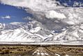
Road to the Shoshone Mountains, winter 2014
.jpg)
