Carvers, Nevada facts for kids
Quick facts for kids
Carvers, Nevada
|
|
|---|---|

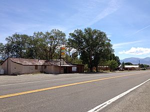
Businesses on SR 376 in Carvers
|
|
| Country | United States |
| State | Nevada |
| County | Nye |
| Elevation | 5,643 ft (1,720 m) |
| Time zone | UTC-8 (Pacific (PST)) |
| • Summer (DST) | UTC-7 (PDT) |
| Area code(s) | 775 |
| GNIS feature ID | 859166 |
Carvers, also known as Carvers Station, is a small community in Nye County, Nevada, USA. It is an unincorporated community, which means it does not have its own local government like a city or town. Carvers is located high up, about 5,643 feet (1,720 meters) above sea level.
History of Carvers
Carvers was started by a couple named Gerald and Jean Carver. Gerald Carver first came to a place called Smoky Valley in Nevada in 1939. He bought a large piece of land there, a 300-acre ranch.
Later, he bought even more land. He added 640 acres from Mimosa Pittman. She was the wife of a famous politician, Senator Key Pittman.
How Carvers Station Began
In 1947, workers started building a new road. This road was called Route 8A, and it is now known as Nevada Route 376. The new road cut right through a part of the Carvers' property.
Gerald and Jean saw this as a great chance. They decided to open a business to serve travelers on the new road. In April 1948, they opened a place called the Rainbow Ranch Bar and Café. Soon after, they changed its name to Carvers Station. This is how the community got its name.
See also
 In Spanish: Carvers (Nevada) para niños
 | Aaron Henry |
 | T. R. M. Howard |
 | Jesse Jackson |


