
Nye County, Nevada facts for kids
Quick facts for kids
Nye County
|
|||
|---|---|---|---|

Nye County Courthouse in Tonopah
|
|||
|
|||

Location within the U.S. state of Nevada
|
|||
 Nevada's location within the U.S. |
|||
| Country | |||
| State | |||
| Founded | 1864 | ||
| Named for | James W. Nye | ||
| Seat | Tonopah | ||
| Largest community | Pahrump | ||
| Area | |||
| • Total | 18,199 sq mi (47,140 km2) | ||
| • Land | 18,182 sq mi (47,090 km2) | ||
| • Water | 17 sq mi (40 km2) 0.1% | ||
| Population
(2020)
|
|||
| • Total | 51,591 | ||
| • Estimate
(2023)
|
55,720 |
||
| • Density | 2.83483/sq mi (1.09453/km2) | ||
| Time zone | UTC−8 (Pacific) | ||
| • Summer (DST) | UTC−7 (PDT) | ||
| Congressional district | 4th | ||


Nye County is a very large area in the state of Nevada, USA. In 2020, about 51,591 people lived there. Its main town, or county seat, is Tonopah.
Nye County is huge! It covers about 18,159 square miles (47,000 square kilometers). This makes it Nevada's largest county by land size. It's also the third-largest county in the contiguous United States. Only San Bernardino County in California and Coconino County in Arizona are bigger.
Most of the people in Nye County live in Pahrump. Pahrump is part of a larger area that includes Las Vegas and Henderson.
A big part of Nye County is managed by the federal government. About 92% of the land is public. This includes places like the Nevada Test Site. This site was used for testing and caused some debate. There was also a plan to store nuclear waste at Yucca Mountain in the county.
Nye County has important natural areas. These include Ash Meadows National Wildlife Refuge and parts of Death Valley National Park. Many visitors to Death Valley stay in towns like Beatty or Amargosa Valley.
The county does not have any official cities. The county seat, Tonopah, is about 160 miles (257 km) from Pahrump. Pahrump is where about 86% of the county's population lives.
Contents
History of Nye County
Nye County was created in 1864 during the American Civil War. It was named after James W. Nye. He was the first governor of the Nevada Territory. Later, he became a U.S. Senator when Nevada became a state.
The first county seat was Ione in 1864. Then it moved to Belmont in 1867. Finally, Tonopah became the county seat in 1905.
Mining Booms and Growth
The county's population grew quickly in the early 1900s. This was because of gold and silver mining. Towns like Rhyolite and Tonopah had mining "booms." A boom means a time of fast growth and wealth.
In 1906, Goldfield, a nearby town, had 30,000 people. Tonopah had almost 10,000, and Rhyolite also reached about 10,000 residents. These towns were connected by a railroad.
After the mining boom ended, Nye County's population dropped. By 1910, it was about 7,500. It fell to around 3,000 by the middle of the century. The population became stable with jobs at the military test site.
In the 1990s, Pahrump started to grow a lot. Many people moved there to live and work in Las Vegas. Pahrump became a "bedroom community" for Las Vegas.
County Changes and Debates
Sometimes, people talk about moving the county seat to Pahrump. Or they discuss splitting the southern part of the county into a new one. But these ideas have not gained enough support.
From 1987 to 1989, a separate area called Bullfrog County was created from Nye County. It had no residents. This was an attempt to stop a nuclear waste storage site from being built. Bullfrog County was dissolved two years later.
Geography of Nye County
Nye County is located in south-central Nevada. It is Nevada's largest county. It is also the third-largest county in the contiguous United States.
The county's land area is about 11.5 million acres (46,700 square kilometers). This is larger than the states of Maryland, Hawaii, Vermont, and New Hampshire. It's even bigger than Massachusetts, Rhode Island, New Jersey, and Delaware combined.
Most of this land, over 90%, is public land. The federal government manages it. The Western Shoshone people traditionally lived in this area.
The highest mountain in the county is Mount Jefferson. It stands at 11,949 feet (3,642 meters) tall.
Nearby Counties
Nye County shares borders with many other counties:
- Churchill County - northwest
- Lander County - north
- Eureka County - north
- White Pine County - northeast
- Lincoln County - east
- Clark County - southeast
- Esmeralda County - west
- Mineral County - west
- Inyo County, California - south
Protected Natural Areas
Nye County is home to several important protected natural areas:
- Ash Meadows National Wildlife Refuge
- Part of Death Valley National Park
- Part of Humboldt-Toiyabe National Forest
- Part of Spring Mountains National Recreation Area
Transportation in Nye County
Public Transit
In 2018, Nye County started its own public transportation service. It's called Pahrump Valley Public Transportation. It serves the town of Pahrump. In 2023, this service also began offering rides to Beatty and Amargosa Valley.
Nye County Transportation Services also provides special rides for seniors and people with disabilities.
Major Highways
U.S. Route 95 runs through Nye County. This is a main road connecting Las Vegas to Carson City, the state capital. Towns like Beatty and Tonopah rely on traffic from this highway. In 2006, about 2,000 cars traveled U.S. 95 near Tonopah every day.
Other important highways in Nye County include:
 Interstate 11 (Future)
 U.S. Route 6
 U.S. Route 95
 State Route 160
 State Route 267
 State Route 318
 State Route 361
 State Route 372
 State Route 373
 State Route 374
 State Route 375
 State Route 376
 State Route 377
 State Route 379
 State Route 844
Population and People
The population of Nye County has changed a lot over time. In 1870, about 1,087 people lived there. The population grew a lot during the mining booms in the early 1900s. Then it dropped before starting to grow steadily again.
By 2020, the population was 51,591. In 2023, it was estimated to be around 55,720 people.
Who Lives in Nye County?
In 2010, there were 43,946 people living in Nye County. Most residents (about 85.9%) were white. Other groups included Black or African American (2.0%), American Indian (1.6%), and Asian (1.3%). About 13.6% of the population was of Hispanic or Latino origin.
The average age of people in Nye County was 48.4 years old.
Education in Nye County
The Nye County School District is in charge of all public schools in Nye County.
High school students from Esmeralda County also attend Tonopah High School. This school is part of the Nye County School District.
The county is also served by Great Basin College.
Communities in Nye County
Nye County has several towns and communities.
Unincorporated Towns
These are towns that are not officially incorporated as cities.
- Amargosa Valley
- Beatty
- Gabbs
- Manhattan
- Pahrump
- Round Mountain
- Tonopah (the county seat)
Unincorporated Communities
These are smaller communities within the county.
Ghost Towns
Nye County also has many ghost towns. These are towns that were once active but are now mostly abandoned.
- Belmont
- Bonnie Claire
- Bullfrog
- Berlin
- Cactus Springs
- Carrara
- Gold Center
- Grantsville
- Ione
- Lockes
- Nyala
- Pioneer
- Potts
- Rhyolite
- Warm Springs
Images for kids
-
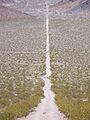
Road from Carrara, Nevada, towards the marble quarry in the background
-
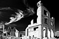
Ruins of the John S. Cook and Company building; occupied in 1908 by the First National Bank, Rhyolite


See also
 In Spanish: Condado de Nye para niños
