
Clark County, Nevada facts for kids
Quick facts for kids
Clark County
|
|||
|---|---|---|---|
      From top, left to right: Caesars Palace panorama, Red Rock Canyon National Conservation Area, Clark County Government Center, Fremont Street Experience, The Venetian, Elephant Rock at Valley of Fire State Park
|
|||
|
|||
| Motto(s):
"Together for Better"
|
|||

Location in the state of Nevada
|
|||

Nevada in the United States
|
|||
| Country | United States | ||
| State | Nevada | ||
| Named for | William A. Clark | ||
| County seat | Las Vegas | ||
| Largest city (population) | Las Vegas | ||
| Largest city (area) | Boulder City | ||
| Government | |||
| • Type | Council–Manager | ||
| Area | |||
| • Total | 8,061 sq mi (20,880 km2) | ||
| • Land | 7,891 sq mi (20,440 km2) | ||
| • Water | 170 sq mi (400 km2) | ||
| Lowest elevation | 492 ft (150 m) | ||
| Population
(2020)
|
|||
| • Total | 2,265,461 | ||
| • Estimate
(2023)
|
2,336,573 |
||
| • Density | 281.040/sq mi (108.510/km2) | ||
| GDP | |||
| • Total | $160.727 billion (2022) | ||
| Time zone | UTC−8 (Pacific Time Zone) | ||
| • Summer (DST) | UTC−7 (Pacific Daylight Time) | ||
| FIPS code | 003-32003 | ||


Clark County is a large county in the state of Nevada, United States. It includes the famous city of Las Vegas and its surrounding areas. The county is huge, covering about 8,061 square miles. That's almost the size of the state of New Jersey!
In 2020, over 2.2 million people lived in Clark County. Most of them live in the Las Vegas area. It is by far the most populated county in Nevada. In fact, it's the 11th most populated county in the entire United States. About 73% of Nevada's population lives in Clark County, even though it only covers 7% of the state's land.
Contents
History of Clark County
Las Vegas, the biggest city in Nevada, has been the main city of Clark County since the county was created. The county was officially formed on February 5, 1909. It was made from a part of Lincoln County. It started operating on July 1, 1909.
Early Inhabitants and Trails
Native Americans lived in the Las Vegas Valley over 10,000 years ago. The Paiute people moved into the area around 700 AD. Later, American fur trappers explored these lands. Their stories led to the first trade route from New Mexico to California in 1829. This route followed the Virgin and Colorado Rivers. It was part of the Old Spanish Trail.
Over time, this trail was changed to be more direct. It moved north from the Colorado River to areas with water, like Las Vegas. In 1844, explorer John C. Frémont added his own shortcut to the trail.
Becoming Part of the United States
What is now Clark County became part of the United States after the Mexican–American War. It was first part of the New Mexico Territory. In 1847, members of the Mormon Battalion created a wagon route through the county. This became known as the "Southern Route" of the California Trail. It was a popular winter route for people going to California during the California Gold Rush.
By the mid-1850s, this route was used for trade between Salt Lake City and Los Angeles. Mormons also built a fort in Las Vegas in the mid-1850s. In the 1860s, more Mormon settlements were started along the Virgin and Muddy Rivers.
County Formation and Naming
Before Nevada became a state, this area was part of Mohave County, Arizona Territory, in 1863. In 1865, it became part of Pah-Ute County, Arizona Territory. In 1866, the part of Pah-Ute County north and west of the Colorado River was given to the new state of Nevada. Arizona fought this change until 1871. Pah-Ute County then became part of Lincoln County.
Clark County was named after William A. Clark. He was a very rich copper businessman and a U.S. Senator from Montana. He helped build the San Pedro, Los Angeles and Salt Lake Railroad through the area. This railroad was very important for the region's early growth.
Today, Clark County is a huge tourist spot. It has about 150,000 hotel rooms! The famous Las Vegas Strip is not actually inside the city limits of Las Vegas. It's in an area called Paradise, which is not an official city. However, it is still part of the larger Las Vegas Valley.
Environmental Challenges
Over time, droughts have become more common and severe in Southern Nevada. This is partly due to climate change. These droughts put a lot of stress on the water supply for Clark County and Las Vegas.
Geography of Clark County

The Colorado River forms the southeastern border of Clark County. The Hoover Dam creates Lake Mead along much of this river. The lowest point in Nevada is in Clark County, south of Laughlin. This is where the Colorado River flows out of Nevada into California and Arizona.
Greater Las Vegas is a valley surrounded by four mountain ranges. Mount Charleston is the highest point, reaching 11,918 feet. It is located to the northwest. Most of Clark County is a desert, except for the forests on Mount Charleston. The main plants are creosote bushes. The mountains are mostly rocky with very little plant life. The land generally slopes towards the south and east.
The county covers about 8,061 square miles. About 7,891 square miles are land, and 170 square miles are water.
Neighboring Counties
Clark County shares borders with several other counties:
- Lincoln County – to the north
- Mohave County, Arizona – to the east (this county uses Mountain Time)
- San Bernardino County, California – to the south
- Inyo County, California – to the northwest
- Nye County – to the west
Protected Natural Areas

Clark County has many protected natural areas. These areas help preserve the unique desert environment. Some of these include:
- Avi Kwa Ame National Monument
- Desert National Wildlife Refuge (part of it)
- Humboldt-Toiyabe National Forest (part of it)
- Lake Mead National Recreation Area (part of it)
- Moapa Valley National Wildlife Refuge
- Red Rock Canyon National Conservation Area
- Sloan Canyon National Conservation Area
- Spring Mountains National Recreation Area (part of it)
- Tule Springs Fossil Beds National Monument (part of it)
There are also twenty official wilderness areas in Clark County. These are special places where the land is kept wild and untouched. Many of them are managed by the Bureau of Land Management (BLM).
Environmental Factors
Clark County has a wide variety of desert plants and animals. This includes life in the mountains, on the desert floor, and around the Colorado River and Lake Mead. The big changes in daily and seasonal temperatures make it challenging for species to live here.
Since 1970, the human population has grown a lot. This growth has put more pressure on the local wildlife. Also, the air quality was good before the 1960s. But with more cars and people, some air quality standards were not met starting in the 1980s.
To help with dust pollution, Clark County started the "Don't Be a Dusthole" campaign in 2003. This campaign successfully made people more aware of dust. It helped reduce pollution and kept federal funding for the area.
The Apex Landfill in Clark County is the largest landfill in the United States. It covers 2,200 acres.
Earthquake Risks
Nevada is the third most active state for earthquakes in the U.S. (after Alaska and California). Experts believe there is a 10–20% chance that Clark County could have a strong earthquake (M6.0 or greater) within 50 kilometers of Las Vegas in the next 50 years.
Population of Clark County
| Historical population | |||
|---|---|---|---|
| Census | Pop. | %± | |
| 1910 | 3,321 | — | |
| 1920 | 4,859 | 46.3% | |
| 1930 | 8,532 | 75.6% | |
| 1940 | 16,414 | 92.4% | |
| 1950 | 48,289 | 194.2% | |
| 1960 | 127,016 | 163.0% | |
| 1970 | 273,288 | 115.2% | |
| 1980 | 463,087 | 69.5% | |
| 1990 | 741,459 | 60.1% | |
| 2000 | 1,375,765 | 85.5% | |
| 2010 | 1,951,269 | 41.8% | |
| 2020 | 2,265,461 | 16.1% | |
| 2023 (est.) | 2,336,573 | 19.7% | |
| US Decennial Census 1790–1960 1900–1990 1990–2000 2010–2018 2022 estimate |
|||


.png)
The population of Clark County has grown a lot over the years. In 1910, there were only 3,321 people. By 2020, the population was over 2.2 million!
| Race / Ethnicity | Pop 2010 | Pop 2020 | % 2010 | % 2020 |
|---|---|---|---|---|
| White alone (NH) | 935,955 | 892,802 | 47.97% | 39.41% |
| Black or African American alone (NH) | 194,821 | 275,002 | 9.98% | 12.14% |
| Native American or Alaska Native alone (NH) | 8,732 | 8,487 | 0.45% | 0.37% |
| Asian alone (NH) | 165,121 | 231,972 | 8.46% | 10.24% |
| Pacific Islander alone (NH) | 12,474 | 18,877 | 0.64% | 0.83% |
| Some Other Race alone (NH) | 3,719 | 12,890 | 0.19% | 0.57% |
| Mixed Race/Multi-Racial (NH) | 61,803 | 124,015 | 3.17% | 5.48% |
| Hispanic or Latino (any race) | 568,644 | 701,416 | 29.14% | 30.96% |
| Total | 1,951,269 | 2,265,461 | 100.00% | 100.00% |
Note: the US Census treats Hispanic/Latino as an ethnic category. This table excludes Latinos from the racial categories and assigns them to a separate category. Hispanics/Latinos can be of any race.

Population Makeup in 2022
In 2022, Clark County had about 857,362 households and 2,322,985 people. The population was made up of different groups. About 37.6% were non-Hispanic white. About 32.6% were Hispanic or Latino (of any race). Other groups included Black (11.7%), Asian (10.7%), and people of mixed races (5.9%).
The largest ancestry groups in the county were Mexican (23.2%), German (7.4%), Filipino (6.8%), English (6.8%), Irish (6.2%), and Italian (4.5%).
Population Details from 2010
In 2010, there were 1,951,269 people living in the county. About 60.9% were White, 13.5% Black, and 8.7% Asian. People of Hispanic or Latino origin made up 29.1% of the population.
The average household had 2.70 people. The average family had 3.26 people. The average age of people in the county was 35.5 years old. The average income for a household was $56,258.
Economy of Clark County
.jpg)


Clark County is home to many companies, especially those related to gaming and entertainment. These include well-known names like MGM Resorts International and Wynn Resorts.
Major Employers

Here are some of the biggest employers in Clark County as of 2012:
- Over 30,000 employees:
* Clark County School District (the local school system)
- 5,000 to 10,000 employees:
* Clark County Government * Nellis Air Force Base * Wynn Las Vegas * Bellagio * MGM Grand Las Vegas * Aria Resort & Casino * Mandalay Bay Resort and Casino * Caesars Palace * Las Vegas Metropolitan Police Department * University of Nevada, Las Vegas
- 2,500 to 4,999 employees:
* The Venetian Las Vegas * The Mirage * The Cosmopolitan of Las Vegas * University Medical Center of Southern Nevada * The Palazzo * Encore Las Vegas * Flamingo Las Vegas * Southwest Airlines * City of Las Vegas municipal Government * Paris Las Vegas
Gaming Areas
Nevada divides the state into different gaming districts. Clark County has several of these:
- Boulder Strip: This area has 33 casinos, including those on Boulder Highway and in Henderson.
- Downtown: This area has 19 casinos.
- LV Strip: This is the famous Las Vegas Boulevard area. It includes casinos from The Stratosphere to Mandalay Bay. Other nearby resorts like The Rio and South Point are also in this district.
- North Las Vegas: This region has 11 casinos, such as the Cannery and Santa Fe Station.
- Laughlin: This district includes all the casinos in the city of Laughlin.
- Mesquite: This district includes all the casinos in the city of Mesquite.
- Balance of County: This category includes 66 other casinos. These are in places like Lake Las Vegas, Jean, Primm, and other areas not covered by the main districts.
Education in Clark County
The Clark County School District serves all of Clark County. It is the fifth largest school district in the country. In 2014, it had 324,093 students. The district has many schools:
- 228 elementary schools
- 59 middle schools
- 54 high schools
There are also several colleges and universities in the area:
- University of Nevada, Las Vegas (UNLV)
- College of Southern Nevada
- Nevada State University
- Roseman University of Health Sciences
- Touro University Nevada
Transportation in Clark County
Public Transit
Public transportation in Clark County is provided by RTC Transit. This is part of the Regional Transportation Commission of Southern Nevada. RTC Transit operates bus services, including The Deuce, which runs between Downtown Las Vegas and the Las Vegas Strip.
Major Roads and Highways
Clark County has a network of important roads and highways:
 Interstate 11
 Interstate 15
 Interstate 215
 U.S. Route 93
 U.S. Route 95
- Many State Routes like SR 146, SR 147, SR 156, and more.
 County Route 215
Rail Services
The Las Vegas Monorail is a public transport system that runs along the Las Vegas Strip. Clark County used to have Amtrak train service called the Desert Wind until 1997. Now, Las Vegas and Laughlin are served by Amtrak Thruway buses. These buses connect to the Southwest Chief train route.
There are also special resort trams that connect different hotels and casinos:
- Aria Express
- Mandalay Bay Tram
- The Mirage-Treasure Island Tram
Communities in Clark County

Clark County has several cities and many other communities.
Cities
- Boulder City (21)
- Henderson (19)
- Las Vegas (10) (This is the county seat, where the county government is located)
- Mesquite (4)
- North Las Vegas (9)
Census-Designated Places (CDPs)
CDPs are areas that look like towns but are not officially incorporated as cities.
- Blue Diamond (18)
- Bunkerville (5)
- Cal-Nev-Ari (23)
- Enterprise (17)
- Goodsprings (20)
- Indian Springs (6)
- Laughlin (24)
- Moapa Town (1)
- Moapa Valley (3)
- Mount Charleston (7)
- Nelson
- Paradise (15)
- Sandy Valley (16)
- Searchlight (22)
- Spring Valley (13)
- Summerlin South (12)
- Sunrise Manor (11)
- Whitney (formerly East Las Vegas) (26)
- Winchester (14)
Air Force Bases
- Creech Air Force Base
- Nellis Air Force Base
Other Communities
These are smaller communities that are not officially cities or CDPs.
- Arden
- Cactus Springs
- Cottonwood Cove
- Coyote Springs (still being planned)
- Crescent
- Crystal
- Fort Mojave Indian Reservation (25)
- Glendale
- Jean
- Logandale
- Las Vegas Indian Colony (8)
- Moapa River Indian Reservation (2)
- Mountain Springs
- Overton
- Primm
- Roach
- Sloan
- Summerlin
- Sutor
- Vegas Creek
Images for kids
-
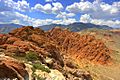
Calico basin in Red Rock Canyon National Conservation Area
See also
 In Spanish: Condado de Clark (Nevada) para niños
