
Inyo County, California facts for kids
Quick facts for kids
County of Inyo
|
||
|---|---|---|

Wildflowers blooming in Death Valley after a wet winter
|
||
|
||

Location in the state of California
|
||
| Country | ||
| State | ||
| Region | Eastern California | |
| Established | March 22, 1866 | |
| Named for | ɨnnɨyun 'it's dangerous' in Timbisha | |
| County seat | Independence | |
| Largest city | Bishop | |
| Government | ||
| • Type | Council–CAO | |
| • Body | Board of Supervisors | |
| Area | ||
| • Total | 10,227 sq mi (26,490 km2) | |
| • Land | 10,181 sq mi (26,370 km2) | |
| • Water | 46 sq mi (120 km2) | |
| Highest elevation | 14,505 ft (4,421 m) | |
| Lowest elevation | -282 ft (−86.0 m) | |
| Population
(2020)
|
||
| • Total | 19,016 | |
| • Estimate
(2023)
|
18,527 |
|
| • Density | 1.85939/sq mi (0.71792/km2) | |
| GDP | ||
| • Total | $1.355 billion (2022) | |
| Time zone | UTC−8 (Pacific Time Zone) | |
| • Summer (DST) | UTC−7 (Pacific Daylight Time) | |
| Area codes | 442/760 | |
| FIPS code | 06-027 | |
| GNIS feature ID | 1804637 | |
| Congressional district | 3rd | |

Inyo County is a large county in the eastern part of California. It sits between the tall Sierra Nevada mountains and the state of Nevada. In 2020, about 19,016 people lived here. The main town, or county seat, is Independence.
Inyo County is known for its amazing natural features. It has the highest point in the lower 48 states, Mount Whitney. It also has the lowest point in North America, Badwater Basin in Death Valley. This makes Inyo County unique with a huge difference in elevation. It is the second-largest county in California by land area. Almost half of Death Valley National Park is located within Inyo County.
Contents
History of Inyo County


For thousands of years, different Native American tribes lived in the area that is now Inyo County. These tribes included the Mono, Timbisha, Kawaiisu, and Northern Paiute. Their descendants still live in the Owens River Valley and Death Valley National Park.
Inyo County was officially created in 1866. It was formed from parts of other counties like Mono County and Tulare County. Over the years, it gained more land from nearby counties.
The name "Inyo" comes from the Timbisha language. Early white settlers thought it meant the name of the mountains. But it actually came from the name of a Timbisha leader named Inyo. In Timbisha, ɨnnɨyun means "it's dangerous."
In the early 1900s, the city of Los Angeles needed more water. So, in 1913, water from the Owens River was sent to Los Angeles through the Los Angeles Aqueduct. This changed the environment and way of life in the Owens Valley. The Los Angeles Department of Water and Power bought much of the land for water rights.
Amazing Natural Places
Inyo County is home to many incredible natural spots. Here are some of them:
- Mount Whitney: This is the highest point in the connected United States. It stands at 14,505 feet (4,421 meters) tall.
- Badwater Basin: Located in Death Valley, this is the lowest point in North America, at 282 feet (86 meters) below sea level.
- Methuselah: This is an ancient Bristlecone pine tree. It is one of the oldest living trees on Earth!
- Owens Valley: This is the deepest valley on the American continents.
- Two mountain ranges that are over 14,000 feet (4,267 meters) high: the Sierra Nevada and the White Mountains.
- Ten of California's twelve peaks that are over 14,000 feet are in Inyo County.
- The largest escarpment (a long, steep slope) in the United States. It rises from the floor of Death Valley to the top of Telescope Peak.

Geography and Landscapes
Mount Whitney is on the western edge of Inyo County. Badwater Basin is in the eastern part. The height difference between these two points is about 14,700 feet (4,480 meters). This is the biggest elevation difference of any county in the United States.
Inyo County covers about 10,227 square miles (26,488 square kilometers). Most of this is land, with a small amount of water. It is the second-largest county in California.
Lakes in Inyo County
Inyo County has several lakes, including:
- Camp Lake
- Cottonwood Lakes
- Diaz Lake
- Lake Sabrina
Protected Natural Areas
A lot of Inyo County's land is protected. These areas help keep nature safe.
- Death Valley National Park (part of it)
- Inyo National Forest (part of it)
- Manzanar National Historic Site
There are also 22 official wilderness areas in Inyo County. These are places where nature is left wild and untouched. Most of these are managed by the Bureau of Land Management. Some also extend into other counties.
Some of these wilderness areas include:
- Argus Range Wilderness
- Coso Range Wilderness
- Death Valley Wilderness (part)
- Inyo Mountains Wilderness (part)
- John Muir Wilderness (part)
- Piper Mountain Wilderness
- Surprise Canyon Wilderness
Death Valley National Park
Death Valley National Park is a very dry national park. It is east of the Sierra Nevada mountains. The park covers a huge area of 5,262 square miles (13,628 square kilometers). It became a national park in 1994.
Death Valley is the hottest and driest national park in the United States. It has the lowest point in North America, Badwater Basin. Many plants and animals live here, even in the harsh desert. Examples include Creosote Bush, Bighorn Sheep, Coyote, and the Death Valley Pupfish. About 95% of the park is a designated wilderness area. Over 770,000 people visit Death Valley National Park each year. They come to see its unique geology, desert wildlife, and clear night skies.
Other Parks and Recreation Areas
- Alabama Hills Recreation Area
- Last Chance Meadow Research Natural Area
- California Bighorn Sheep Zoological Area
People and Population
Inyo County has a small population for its size. In 2020, about 19,016 people lived there. The county is home to people from many different backgrounds. Many residents have Native American, White, or Hispanic/Latino heritage. The population density is very low, with only about 1.8 people per square mile.
Education in Inyo County
Students in Inyo County attend schools in several different school districts:
- Big Pine Unified School District
- Bishop Unified School District
- Bishop Union High School District
- Bishop Union Elementary School District
- Death Valley Unified School District
- Lone Pine Unified School District
- Owens Valley Unified School District
- Round Valley School District
For college, students can go to Deep Springs College, a two-year school. Higher education is also provided by the Kern Community College District.
Places to Visit
Inyo County has many interesting places to see:
- Mushroom Rock
- Mount Whitney
- Death Valley National Park
- Badwater Basin
- Lake Manly
- Furnace Creek: This place holds the record for the hottest air temperature ever recorded on Earth (134.6°F or 57°C in 1913). The ground temperature here once reached 201°F (94°C)!
Getting Around Inyo County

For many years, people wanted to build more roads across the Sierra Nevada mountains. However, groups like the Forest Service and the Sierra Club wanted to protect the wild, roadless areas. Because of their efforts, many areas remained wilderness. One route, Sherman Pass, was completed in 1976.
Main Roads
The major highways that go through Inyo County include:
 U.S. Route 6
 U.S. Route 395
 State Route 127
 State Route 168
 State Route 190
Buses and Airports
The Eastern Sierra Transit Authority offers bus services. These buses travel along US 395 and also provide local service in Bishop. You can take a bus south to Lancaster or north to Reno, Nevada.
There are several airports for small planes:
- Bishop Airport
- Independence Airport
- Lone Pine Airport
- Shoshone Airport
- Stovepipe Wells Airport and Furnace Creek Airport are inside Death Valley National Park.
Towns and Communities

Inyo County has one city and many smaller towns and communities.
City
Census-Designated Places (CDPs)
These are areas that are like towns but are not officially incorporated as cities.
- Big Pine
- Cartago
- Charleston View
- Darwin
- Dixon Lane-Meadow Creek
- Furnace Creek
- Homewood Canyon
- Independence (This is the county seat!)
- Keeler
- Lone Pine
- Mesa
- Olancha
- Pearsonville
- Round Valley
- Shoshone
- Tecopa
- Trona
- Valley Wells
- West Bishop
- Wilkerson
Other Communities
These are smaller, unincorporated communities:
- Alabama Hills
- Chicago Valley
- Coso Junction
- Death Valley Junction
- Deep Springs
- Dunmovin
- Haiwee
- Laws
- Panamint Springs
- Sandy Valley
- Stewart Valley
Images for kids
-
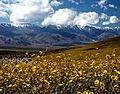
Wildflowers blooming in Death Valley after a wet winter
-
Seal of Inyo County, California
-
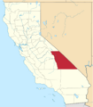
Location of Inyo County in California
See also
 In Spanish: Condado de Inyo para niños
