White Mountains (California) facts for kids
Quick facts for kids White Mountains |
|
|---|---|
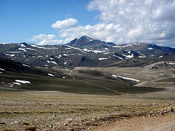
White Mountain Peak from access road
|
|
| Highest point | |
| Peak | White Mountain Peak |
| Elevation | 14,252 ft (4,344 m) |
| Dimensions | |
| Length | 60 mi (97 km) |
| Width | 10 mi (16 km) |
| Geography | |
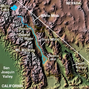
The White Mountains along the east side of Owens Valley
|
|
| Country | United States |
| Range coordinates | 37°35.0′N 118°16.05′W / 37.5833°N 118.26750°W |
| Parent range | Basin and Range Province |
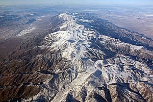
The White Mountains are a mountain range in California and Nevada. They are shaped like a triangle and stand across the Owens Valley from the Sierra Nevada mountains. These mountains were formed when large blocks of the Earth's crust moved along cracks called faults.
The White Mountains stretch for about 60 miles (97 km). They are about 20 miles (32 km) wide at their southern end and get narrower towards the north. The mountains generally get taller as you go from south to north. The southern part is near Big Pine, where Westgard Pass separates them from the Inyo Mountains. The northern end is at Montgomery Pass. The Fish Lake Valley is to the east. The entire range is part of the Inyo National Forest.
Contents
Nature and Animals
The White Mountains are a dry place, much like other ranges in the Basin and Range Province. However, their higher slopes, from about 9,200 to 11,500 feet (2,800 to 3,500 meters), have open forests. Here you can find Great Basin bristlecone pine trees growing on certain types of rock like dolomite and granite. Limber pine trees grow on other rocky areas.
Lower down, from about 6,500 to 8,200 feet (2,000 to 2,500 meters), there are more trees. These include piñon pine and Utah juniper. Often, a zone of mountain mahogany bushes separates these higher and lower tree areas. Different kinds of sagebrush plants grow from the valleys up to the lower parts of the mountains.
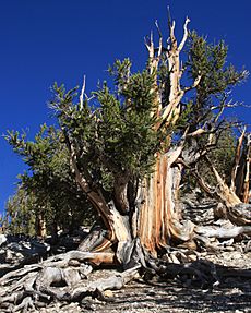
One very special tree in these mountains is a bristlecone pine named Methuselah. It is the oldest known living tree in the world, over 4,800 years old! The Paiute Indians, whose families still live in nearby valleys, used to collect pine nuts from the piñon pine trees. These nuts were an important food for them in winter.
The White Mountains also have small groups of other trees. These include lodgepole pine, Jeffrey pine, ponderosa pine, Sierra juniper, and aspen. Some aspen trees here are an unusual dwarf type. These trees are more common in the wetter Sierra Nevada mountains nearby. They likely grew more widely in the White Mountains in the past, but dry periods caused them to disappear from most of this drier range. Some plant species are found only in the White Mountains, like the White Mountains horkelia.
The animals living here include two groups of bighorn sheep, mule deer, marmots, and wild horses. The streams do not have native fish. However, there are populations of trout, including rare Paiute cutthroat trout. These trout are protected and cannot be caught by fishing. Birds like Clark's nutcracker and other Corvidae birds eat and hide pine nuts.
History of the Mountains
In the past, and even today, cattle from nearby ranches graze in the White Mountains. They are allowed to graze as high as the very top parts of the mountains. Long ago, many sheep also grazed here. They brought diseases that the native Bighorn Sheep are still slowly recovering from.
Before people from Europe settled in the valleys in the mid-1800s, Paiute Indians used to have summer hunting camps high up in the mountains. Some of these camps were as high as 13,100 feet (4,000 meters). You can still find the remains of these old camps, which are interesting for archaeologists to study.
Mountain Geography
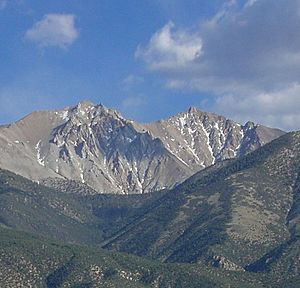
The tallest point in the White Mountains is White Mountain Peak. It is 14,252 feet (4,344 meters) high, making it the third-highest peak in California. This peak is actually an old, extinct volcano. It rises about 1,600 feet (490 meters) above the flat area around it. The top of the peak is made of volcanic rock that was lifted and melted by rising granite. The volcano itself is long gone.
The White Mountains are the highest mountain range that is completely inside the Great Basin. The nearby Sierra Nevada Range, which is on the western edge of the Great Basin, has two even higher peaks. The entire White Mountains range is located within the Inyo National Forest.
Mountain Weather
Mount Barcroft is a mountain peak about 3.5 miles (5.6 km) south of White Mountain Peak.
| Climate data for Mount Barcroft 37.5816 N, 118.2486 W, Elevation: 12,743 ft (3,884 m) (1991–2020 normals) | |||||||||||||
|---|---|---|---|---|---|---|---|---|---|---|---|---|---|
| Month | Jan | Feb | Mar | Apr | May | Jun | Jul | Aug | Sep | Oct | Nov | Dec | Year |
| Mean daily maximum °F (°C) | 26.1 (−3.3) |
23.4 (−4.8) |
26.9 (−2.8) |
30.2 (−1.0) |
37.7 (3.2) |
52.1 (11.2) |
59.5 (15.3) |
58.5 (14.7) |
50.0 (10.0) |
41.3 (5.2) |
32.8 (0.4) |
25.1 (−3.8) |
38.6 (3.7) |
| Daily mean °F (°C) | 17.7 (−7.9) |
15.0 (−9.4) |
17.9 (−7.8) |
20.9 (−6.2) |
27.0 (−2.8) |
38.5 (3.6) |
45.3 (7.4) |
44.3 (6.8) |
39.7 (4.3) |
32.0 (0.0) |
23.9 (−4.5) |
17.2 (−8.2) |
28.3 (−2.1) |
| Mean daily minimum °F (°C) | 9.2 (−12.7) |
6.6 (−14.1) |
9.0 (−12.8) |
11.7 (−11.3) |
16.3 (−8.7) |
24.9 (−3.9) |
31.2 (−0.4) |
30.4 (−0.9) |
29.3 (−1.5) |
22.7 (−5.2) |
15.1 (−9.4) |
9.3 (−12.6) |
18.0 (−7.8) |
| Average precipitation inches (mm) | 3.40 (86) |
3.17 (81) |
3.08 (78) |
1.70 (43) |
1.35 (34) |
0.69 (18) |
0.98 (25) |
1.00 (25) |
0.47 (12) |
1.49 (38) |
0.83 (21) |
2.88 (73) |
21.04 (534) |
| Source: PRISM Climate Group | |||||||||||||
| Climate data for Sheep Mountain (CA) 37.5269 N, 118.2174 W, Elevation: 12,152 ft (3,704 m) (1991–2020 normals) | |||||||||||||
|---|---|---|---|---|---|---|---|---|---|---|---|---|---|
| Month | Jan | Feb | Mar | Apr | May | Jun | Jul | Aug | Sep | Oct | Nov | Dec | Year |
| Mean daily maximum °F (°C) | 27.9 (−2.3) |
26.3 (−3.2) |
29.6 (−1.3) |
32.4 (0.2) |
40.2 (4.6) |
54.0 (12.2) |
61.3 (16.3) |
60.3 (15.7) |
51.7 (10.9) |
42.4 (5.8) |
34.7 (1.5) |
27.3 (−2.6) |
40.7 (4.8) |
| Daily mean °F (°C) | 19.5 (−6.9) |
17.6 (−8.0) |
20.4 (−6.4) |
23.4 (−4.8) |
29.4 (−1.4) |
40.6 (4.8) |
47.5 (8.6) |
46.6 (8.1) |
41.0 (5.0) |
33.0 (0.6) |
25.9 (−3.4) |
19.4 (−7.0) |
30.4 (−0.9) |
| Mean daily minimum °F (°C) | 11.2 (−11.6) |
8.9 (−12.8) |
11.1 (−11.6) |
14.3 (−9.8) |
18.7 (−7.4) |
27.3 (−2.6) |
33.8 (1.0) |
32.9 (0.5) |
30.4 (−0.9) |
23.7 (−4.6) |
17.1 (−8.3) |
11.5 (−11.4) |
20.1 (−6.6) |
| Average precipitation inches (mm) | 3.18 (81) |
3.25 (83) |
2.81 (71) |
1.60 (41) |
1.30 (33) |
0.60 (15) |
0.91 (23) |
0.87 (22) |
0.50 (13) |
1.32 (34) |
0.89 (23) |
2.73 (69) |
19.96 (508) |
| Source: PRISM Climate Group | |||||||||||||
Hiking and Exploring
A road for four-wheel drive vehicles goes all the way to the top of White Mountain Peak from the south. This road is used to reach the White Mountain Research Center laboratory at the summit. The road is usually closed about seven miles (11 km) from the top, at an elevation of 11,680 feet (3,560 meters). This makes White Mountain Peak one of California's easiest 14,000-foot (4,300-meter) summits to reach.
North of White Mountain Peak, the mountain crest has sharp ridges and wide, flat areas called Pellisier Flats. There are about six more peaks over 13,000 feet (4,000 meters) here. Pellisier Flats is a wide, gently sloping area at about 13,000 feet (4,000 meters) with rocky ground and short alpine plants. It includes Mount Hogue at 12,743 feet (3,884 meters) and Mount Dubois at 13,559 feet (4,133 meters), which is the highest point on the plateau. Pellisier Flats forms the broad backbone of the White Mountains.
The mountain crest crosses the California–Nevada state line just south of Boundary Peak. At 13,147 feet (4,007 meters), Boundary Peak is the highest point in Nevada. It offers amazing views directly down into the valleys to the west, north, and east. These views are hidden further south because the high plateau gets wider. North of Boundary Peak, the mountains quickly get lower and end at Montgomery Pass.
The western side of the White Mountains rises very steeply from the Owens Valley. Climbing to any summit from this direction is a challenging scramble, with about 8,000 feet (2,400 meters) of elevation gain. The eastern slopes are a bit gentler. They have many bowl-shaped valleys called cirques, which were carved out by glaciers long ago. Some snowfields even remain through most summers. Many of these cirques can be reached by jeep roads and offer beautiful, but not too difficult, routes to the mountain crest.
 | Dorothy Vaughan |
 | Charles Henry Turner |
 | Hildrus Poindexter |
 | Henry Cecil McBay |


