Owens Valley facts for kids
Quick facts for kids Owens Valley |
|
|---|---|
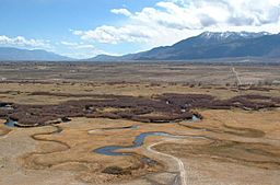
Owens River from Bishop Tuff tableland.
|
|
 |
|
| Floor elevation | 4,000 feet (1,200 m) |
| Length | 75 miles (121 km) North to South |
| Naming | |
| Native name | Error {{native name}}: an IETF language tag as parameter {{{1}}} is required (help) |
| Geography | |
| Population centers | Bishop, Lone Pine, Independence, Big Pine |
| Borders on | Inyo Mountains (E) Coso Range (SE) Rose Valley (S) Sierra Nevada (W) Chalfant Valley (N) |
| Traversed by | U.S. Route 395 |
| Rivers | Owens River |
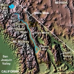
The Owens Valley (in the Mono language, Payahǖǖnadǖ means "place of flowing water") is a dry valley in eastern California, United States. It's located east of the tall Sierra Nevada mountains and west of the White Mountains and Inyo Mountains. The valley is part of both the Great Basin Desert and the Mojave Desert.
The mountains on the west side, like Mount Whitney, are very high, reaching over 14,000 feet (4,300 m). The valley floor is much lower, around 4,000 feet (1,200 m). This makes Owens Valley the deepest valley in the United States. The Sierra Nevada mountains block rain from reaching the valley, creating a "rain shadow." This is why Owens Valley is often called "the Land of Little Rain."
At the southern end of the valley is Owens Lake. It used to be a large lake, but now it's mostly a dry, salty alkali flat. This is because the Los Angeles Department of Water and Power (LADWP) started taking water from the region.
The Owens Valley provides water to the Los Angeles Aqueduct. This aqueduct supplies about one-third of the water for the city of Los Angeles. The fight over this water led to the famous "California Water Wars." Owens Lake became completely dry by 1926, just 13 years after Los Angeles began diverting its water. This water struggle even inspired parts of the 1974 movie Chinatown.
Some towns in the Owens Valley include Bishop, Lone Pine, Independence, and Big Pine. About 25,000 people live in the valley. The main road through the Owens Valley is U.S. Route 395.
Contents
Geology: How the Valley Was Formed
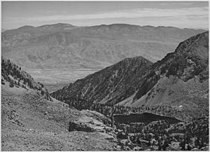
About three million years ago, huge cracks in the Earth's crust, called faults, became active. These were the Sierra Nevada Fault and the White Mountains Fault. Repeated earthquakes along these faults slowly created the impressive mountains you see today. They also caused the land in between to drop down.
The Owens Valley is a type of valley called a graben. This means it's a block of land that has dropped down between two parallel faults. It's also part of a long, deep ditch that stretches from Oregon all the way to Death Valley, known as the Walker Lane.
On the western side of the valley, you can see large piles of rocks and dirt called moraines. These were left behind by huge sheets of ice, called glaciers, during the last ice age. A great example of a moraine can be seen on State Route 168 as it goes up into the Buttermilk Country.
The valley floor is much deeper than it looks. Studies show that about 10,000 feet (3,048 m) of sedimentary rock fills the graben. This means there's a very steep cliff buried under the western side of the valley. You can see the top part of this buried cliff at the Alabama Hills.
The Owens Valley also has many small volcanoes. One example is Crater Mountain in the Big Pine volcanic field. You can even find smaller versions of the famous Devils Postpile near Little Lake.
Ecology: Plants and Animals
The Owens Valley is a unique place because it sits where four different natural areas, called ecoregions, meet. These include parts of the Great Basin Desert and the Mojave Desert.
The valley floor, especially north of Independence, California, is part of the "Upper Owens Valley" ecoregion. This area has gently sloping land and flat basin floors. The land is covered with alluvium, which is soil and rock deposited by water. You'll mostly find rangeland here, covered in shrubs like big sagebrush and rabbitbrush. Along the Owens River, efforts have been made to bring back cottonwood trees, willows, and wetlands.
The eastern slopes of the valley are part of the "Tonopah Sagebrush Foothills" ecoregion. The soil here is rocky. Because it's in the rain shadow of the Sierra Nevada, it's very dry. You'll find plants like black sagebrush here. Some plants from the Mojave Desert, like blackbrush and Joshua tree, also grow in areas that get a bit more summer rain. Streams here only flow during and right after storms.
The southern part of the valley, except for the dry bed of Owens Lake, is in the "Western Mojave Basins" ecoregion. This area is mostly covered by creosotebush and white bursage. You might also see shadscale and, on higher slopes, scattered Joshua trees. This part of the desert gets less summer rain than other Mojave Desert areas.
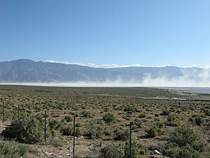
The dry bed of Owens Lake is called a "Mojave Playa." The soil here has a lot of salt and clay, and it's very hot and dry. This makes it hard for plants to grow. It's mostly barren, with only a few saltbush plants around the edges. These dry lakebeds are always changing with each flood, and special soil crusts help keep the soil from blowing away.
The valley is home to plants that can live in salty, dry areas. One special plant, the Owens Valley checkerbloom (Sidalcea covillei), grows only in the Owens Valley.
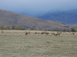
Tule elk are a type of elk that were brought to the Owens Valley in 1933. From just 56 elk, their numbers grew to 300 by 1952. This caused some problems with local ranchers because the elk would damage their property. Today, the total elk population is carefully managed to be around 490.
History of Owens Valley

For a very long time, the Owens Valley was home to Native American tribes. The Timbisha people lived in the southern part of the valley near Owens Lake. The Mono tribe (also called Owens Valley Paiute) lived in the central and northern parts. These tribes lived along the rivers and creeks that were fed by snowmelt from the Sierra Nevada mountains. They traded with other tribes, even those near the coast.
In 1834, Joseph R. Walker was one of the first non-Native Americans to enter the Owens Valley from the south. In 1845, John C. Fremont named the valley, river, and lake after Richard Owens, one of his guides. Later, Camp Independence was set up near modern Independence in 1862 during the Owens Valley Indian War.
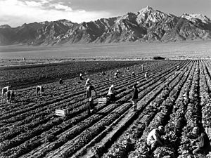
During World War II, from 1942 to 1945, a Japanese American Internment camp called Manzanar was located in the valley near Independence. This was a place where Japanese Americans were forced to live during the war.
The California Water Wars
In the early 1900s, a big conflict started over water in the Owens Valley. The city of Los Angeles needed more water for its growing population. William Mulholland, who was in charge of the Los Angeles Department of Water and Power (LADWP), planned a long aqueduct to bring water from the Owens River to Los Angeles. This aqueduct was finished in 1913.
Los Angeles bought many water rights and a lot of land in the valley. This caused problems for the local farmers and ranchers. By 1924, some farmers were so angry that they damaged parts of the aqueduct system.
Eventually, Los Angeles bought most of the water rights in the valley. This meant that the water that used to flow into Owens Lake was almost completely redirected. As a result, the lake dried up, leaving behind a dusty, salty flat. This dry lakebed now causes dust storms in the southern valley.
In 1970, LADWP built a second aqueduct. This meant even more surface water was taken, and groundwater was pumped out. Many springs and wet areas in the Owens Valley dried up, and plants that depended on groundwater started to die.
For many years, there were lawsuits and agreements about the water. In 1997, Los Angeles and other groups agreed to put water back into the lower Owens River by 2003. Los Angeles missed this deadline, leading to more lawsuits. Finally, in 2008, Los Angeles kept its promise and rewatered the lower Owens River.
More recently, Los Angeles has been working to control the dust that blows off the dry Owens Lake bed. This is important for air quality in the valley.
Owens Valley Radio Observatory
The Owens Valley Radio Observatory is located near Westgard Pass. It's a special place where scientists use large radio dishes to study space. It's one of ten dishes that make up the Very Long Baseline Array (VLBA), which works like one giant telescope.
See also
 In Spanish: Valle Owens para niños
 | Isaac Myers |
 | D. Hamilton Jackson |
 | A. Philip Randolph |


