
Big Pine volcanic field facts for kids
Quick facts for kids Big Pine volcanic field |
|
|---|---|
| Aberdeen volcanic field | |

Cinder cones at Fish Springs, CA
|
|
| Highest point | |
| Geography | |

Big Pine volcanic field
Location in California
|
|
| Geology | |
| Age of rock | Pleistocene |
| Mountain type | Volcanic field |
| Last eruption | 17,000 years ago. |
The Big Pine volcanic field is a group of volcanoes in Inyo County, California. It covers about 500 square kilometers (193 square miles) in the Owens Valley. This area is east of the Sierra Nevada mountains. The field has many lava flows, one rhyolite lava dome, and about 40 volcanic openings. These openings include cinder cones, which are cone-shaped hills made of volcanic rock. Some are simple cones, while others are more uneven. In the past, glaciers and large lakes changed how the lava flows look.
Volcanic activity here started 1.2 million years ago. It was shaped by cracks in the Earth called faults that run through the valley. Eruptions continued into the Pleistocene epoch. The most recent eruption happened about 17,000 years ago. This event created new cones and several lava flows. If volcanoes here became active again, a major road and the Los Angeles Aqueduct could be in danger.
Contents
Where is the Big Pine Volcanic Field?
The Big Pine volcanic field is also known as the Aberdeen volcanic field. It is located in the Owens Valley, near Aberdeen, California. You can find it between the towns of Big Pine and Independence. U.S. Route 395 and the Owens River both pass through this volcanic area. The Owens River is held back by a dam north of the field, forming the Tinemaha Reservoir.
What Does the Volcanic Field Look Like?
The field covers about 500 square kilometers (193 square miles). It has 25 main volcanoes and about 15 other openings. You can see volcanic cones on both sides of the valley. Some are perfectly shaped cones, while others are more irregular. The uneven ones are usually found at the edge of the valley. The symmetrical cones are on the valley floor. Crater Mountain and Red Mountain are two well-known cones in the field. You'll usually find small volcanic rocks, called pyroclastic material, only near the openings. There is also one rhyolite lava dome in the field.

Around Aberdeen, lava flows from different volcanoes form a large area. These flows include both aa and pahoehoe types of lava. They still have their original surface features, which are well-preserved. Some lava flows are up to 9 kilometers (5.6 miles) long. They can be from 0.01 to 30 meters (0.03 to 98 feet) thick. Sometimes, lava flows from different cones overlap, like in Papoose Canyon.
How Did Lakes and Glaciers Change the Area?
In the past, large pluvial lakes and glaciers covered the Owens Valley. Volcanic activity at Big Pine happened during these times. The lakes and glaciers actually affected the volcanoes. For example, Owens Lake spread across much of the valley during ice ages. It carved marks into the lava flows, showing its old shorelines. Some lava flows are now covered by glacial material and sediment. Deep wells have even found buried lava flows as deep as 250 meters (820 feet) underground.
The ground beneath the valley is made of old rocks from the Mesozoic Era. These rocks are found in the White Mountains and the Sierra Nevada. The valley floor itself is covered with alluvium, which is sand and gravel carried by water. The Owens Valley is a graben, which means it's a sunken block of land. It formed because the Sierra Nevada-Great Valley Block moved away from the rest of North America. South of Big Pine is the Coso Volcanic Field, which is active with geothermal heat, but Big Pine is not.
Why Are There Volcanoes Here?
Scientists have different ideas about why volcanoes exist in the Basin and Range province. One idea is that the Earth's crust is stretching apart. This stretching allows hot material from the mantle (the layer below the crust) to rise up. There are several volcanic fields in Eastern California, and Big Pine is one of them.
The volcanoes at Big Pine are connected to the stretching of the Basin and Range province. The volcanic openings at Big Pine are found along faults. These include the Owens Valley fault, the Sierra Nevada Fault, and the White Mountains fault. These faults have even shifted some of the lava flows. Studies using sound waves show that the lithosphere (the Earth's rigid outer layer) is thinner under Big Pine.
What Are the Rocks Made Of?
The Big Pine volcanic field has erupted basaltic rocks. These rocks range from alkali basalt to basanite. There is also one type of silicic rock. The rocks contain small crystals called phenocrysts, such as olivine, plagioclase, and clinopyroxene. They also have pieces of other rocks called xenoliths, like lherzolite and pyroxenite.
The molten rock, or magma, that erupted at Big Pine came from the lithospheric mantle. This mantle material was changed by processes that happened 1.8 billion years ago. Research suggests that two different magmas mixed and melted to create the rocks we see today. The magma at Big Pine rose quickly to the surface. This fast movement prevented the formation of rhyolites, which would need the magma to stay longer underground.
Climate and Plants
The Owens Valley is a windy and sunny place. Temperatures can swing widely, from about 42°C (107°F) to -19°C (-2°F) each year. There are also big temperature changes between day and night. The valley is in the rain shadow of the Sierra Nevada mountains. This means it's very dry, getting only about 127 millimeters (5 inches) of rain each year.
The plants in the valley are special. They are adapted to dry and semi-dry climates. You can find plants like Alkali sacaton, big sagebrush, greasewood, Nevada saltbush, rubber rabbitbrush, salt grass, and shadscale. These plants often grow in places where water is more available. This includes old stream beds, low areas, and along fault lines.
When Did the Volcanoes Erupt?
Volcanic activity at Big Pine happened during the Quaternary period. It produced about 0.5 cubic kilometers (0.12 cubic miles) of rock. Eruptions took place from 1.2 million years ago until 17,000 years ago. Most of the rocks erupted between 500,000 and 100,000 years ago. It seems that changes in the Earth's crust due to glaciers affected how often eruptions happened. Eruptions were less common during ice ages.
The oldest volcanic features are 1.2 million years old. They are found in the Oak Creek area, but only parts of them remain today. The rhyolite erupted about 990,000 years ago. Later eruptions happened at different times and places. For example, Papoose Canyon had eruptions about 760,800 years ago. Jalopy Cone erupted about 469,400 years ago. Quarry Cone erupted about 90,500 years ago. Volcanic Bomb Cone erupted about 61,600 years ago. Goodale Bee Cone erupted about 31,800 years ago. The Blackrock Springs lava flowed about 27,000 years ago.
The youngest eruptions, about 17,000 years ago, created the Armstrong Canyon, Division Creek, and Taboose Creek lava flows. These flows came from the same event. This event also formed Armstrong Canyon cone and several scoria cones. The lava flows stretched for 6 kilometers (3.7 miles) along the Sierra Nevada fault. This eruption might have produced as much as 0.6 cubic kilometers (0.14 cubic miles) of tephra (volcanic ash and rock fragments). The lava flows mixed with water, forming a special rock called palagonite. Later, Owens Lake eroded these young lava flows and the Blackrock Springs lava when the lake was at its highest level during the last ice age.
Are There Any Dangers?
Volcanoes in Eastern California, like Long Valley Caldera, Coso, and Big Pine, are still considered potentially dangerous. Future eruptions at Big Pine could affect the Los Angeles Aqueduct and US. Route 395. The aqueduct provides a lot of water to Los Angeles, sometimes more than half of the city's water. US. Route 395 is a busy road used by many people traveling between Mammoth Lakes and Los Angeles.
Gallery
-
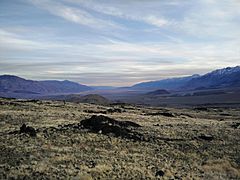
Cinder cones in the background
-
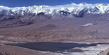
Tinemaha Reservoir, with cinder cones in the middle and left parts of the image
-
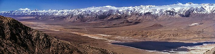
Owens Valley, with cones visible in the centre-right part of the image


