Owens River facts for kids
Quick facts for kids Owens River |
|
|---|---|

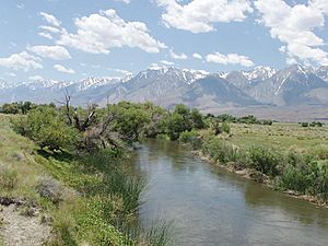
Owens River south of Poverty Hills
|
|

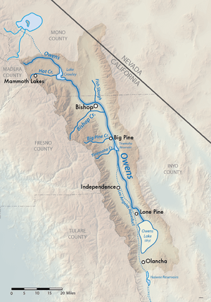
Map of the Owens Lake watershed, including Los Angeles Aqueduct system
|
|
|
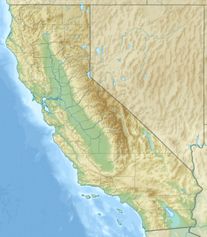
Location of the mouth of the Owens River in California
|
|
| Other name(s) | Wakopee |
| Country | United States |
| State | California |
| District | Mono County, Inyo County |
| Cities | Mesa, Bishop, Big Pine, Elna (site), Chrysopolis (site), Independence, Lone Pine |
| Physical characteristics | |
| Main source | Confluence of Deadman Creek and an unnamed stream Inyo National Forest, Mono County 7,251 ft (2,210 m) 37°45′01″N 118°56′20″W / 37.75028°N 118.93889°W |
| River mouth | Owens Lake A few miles northwest of Keeler, Inyo County 3,592 ft (1,095 m) 36°32′31″N 117°58′45″W / 36.54194°N 117.97917°W |
| Length | 183 mi (295 km), north-south |
| Basin features | |
| Basin size | 2,604 sq mi (6,740 km2) |
| Tributaries |
|
The Owens River is a river in eastern California, United States. It is about 183 miles (295 km) (295 km) long. This river flows through the Owens Valley, which is a dry area. It sits between the Sierra Nevada mountains on one side and the Inyo Mountains and White Mountains on the other.
The Owens River ends at Owens Lake, which is mostly dry. This lake is south of Lone Pine. The river and its surrounding land form a watershed of about 2,600 sq mi (6,700 km2).
In the early 1900s, the Owens River became famous for the California Water Wars. This was a big conflict between the city of Los Angeles and the people living in Owens Valley. The fight was about building the Los Angeles Aqueduct. Since 1913, much of the Owens River's water has been sent to Los Angeles. This caused problems for the valley's economy and dried up Owens Lake.
In 2006, the Los Angeles Department of Water and Power (LADWP) had to restore some water to the river. A court order made them return 5% of the river's original flow. This helped bring a small amount of water back to the Owens River Gorge and Owens Lake.
Contents
Journey of the Owens River
The Owens River starts in the Sierra Nevada mountains. This is in southwestern Mono County. It begins about 15 miles (24.1 km) south of Mono Lake. It is also about 35 miles (56.3 km) east of Yosemite Valley.
River's Path Through Valleys
The river flows southeast through the Long Valley Caldera. It then goes into Lake Crowley, which is a reservoir. After that, it drops through the 20-mile-long (32 km) Owens River Gorge. It then reaches the northern part of the Owens Valley, near Bishop.
Around Bishop, farmers use many ditches to take water from the river. This water helps them grow crops in the area. The river then flows south-southeast through the Owens Valley. The Sierra Nevada mountains are to its west. The White and Inyo Mountains are to its east. It flows past Big Pine.
Water Diversion to Los Angeles
About 14 miles (22.5 km) south of Big Pine, most of the river's water is sent into the Los Angeles Aqueduct. This aqueduct was finished in 1913. It carries water for homes, recreation, and farms in Los Angeles.
The smaller amount of water left in the river flows through the southern valley. It runs alongside the Los Angeles Aqueduct. It passes Lone Pine. Finally, it enters the mostly dry lake bed of Owens Lake at the southern end of Owens Valley.
Owens River Watershed and Landscape
The Owens River flows through two main valleys in the southwestern Great Basin. These are the Long Valley and the Owens Valley. The river's drainage basin stretches from north to south. It covers parts of Mono and Inyo counties. It ends at the now-dry Owens Lake.
Geographic Features of the Basin
Northwest of the valley is the Long Valley Caldera. This area is much smaller than the Owens Valley. The Owens River enters Owens Valley from the northwest. Another stream, Spring Valley Wash, drains the northernmost part of the valley. This extends a tiny part of the basin into Nevada.
The river mainly flows on the east side of the valley. This is because dirt and rocks from the Sierra Nevada streams have pushed the river channel in that direction.
Elevations and Population
The height differences in the basin are huge. Elevations range from 14,505 feet (4,421 m) at Mount Whitney. This is the highest peak in the continental United States. The lowest point is 3,556 feet (1,084 m) on the bed of Owens Lake. The Owens River itself starts at an elevation of 7,291 feet (2,222 m).
Few people live in the open grasslands and steep mountainsides of the watershed. In 2009, Mono County had about 12,927 people. Inyo County had about 17,293 residents. The biggest city on the river is Bishop. It has just under 4,000 people. Other towns include Lone Pine (population 2,035), Big Pine (population 1,707), and Independence (population 669).
Geology of the Owens River Area
The Owens River flows through a part of North America called the Basin and Range Province. The Owens Valley is a graben. This is a section of land that has dropped down. It is between two parallel faults. The land on either side has risen. This creates the flat floor and tall, steep walls of the valley we see today.
Deep Valley Formation
The Sierra Nevada mountains are on the west side. The Inyo Mountains and White Mountains are on the east. The highest peaks in these ranges are over 14,000 feet (4,300 m). The valley floor is much lower, at about 3,000 to 4,000 feet (910 to 1,220 m). This makes the Owens River flow through one of the deepest valleys in the United States.
Volcanic History of the Region
Further north, the Owens River basin has many igneous rocks. These are rocks formed from cooled lava. There are also large signs of past volcanic activity. The upper 30 miles (48 km) of the river flow through the Long Valley Caldera. This is a huge crater, about 20-mile (32 km)-wide. It was formed by a volcanic eruption about 760,000 years ago. The ash from this eruption covered much of the southwestern United States. It even reached parts of ten U.S. states.
Mammoth Mountain, a popular ski area, also formed from eruptions linked to the Long Valley Caldera. North of the Caldera are the Mono–Inyo Craters. These are a chain of volcanoes. They range in age from 400,000 to 500 years old.
Ancient River and Lake Systems
During the Pleistocene Ice Age, glaciers melted in the Sierra Nevada and Inyo/White Mountains. This sent huge amounts of water into the Owens River. The river grew much larger than it is today. Owens Lake also grew, eventually spilling out of the valley into the Mojave Desert.
Old, now-empty river channels show that the expanded Owens River flowed south. It went to China Lake, then east into Searles Lake. From there, it went north into the Panamint Valley, forming Panamint Lake. Finally, it flowed east into Death Valley and the ancient Lake Manly. This large inland sea also received water from the Mojave River from the south. The Amargosa River flowed in from the east, and the Death Valley Wash from the north.
For a short time, the Owens River was part of a huge inland water system. This system covered over 8,000 square miles (21,000 km2). At its peak, water from this massive basin might have even reached the Colorado River.
History of the Owens River Valley
For thousands of years, the Owens River valley was home to Native American tribes. These included the seminomadic Owens Valley Northern Paiute and the Shoshone tribes. The native name for the river was Wakopee. They called Owens Lake Pacheta.
Early Irrigation Systems
In the upper Owens Valley, you can find traces of California's first irrigation systems. Paiute groups created these to water small areas of crops. It is believed that native people in the upper valley built dams across the Owens River. They may have also dammed Bishop Creek, a major tributary. This was to send water into local canals. People likely switched from hunting and gathering to farming because the Owens Valley climate became drier about 1,000 years ago.
Native Americans typically built dams across the river or other streams in the spring. They used materials like boulders, dirt, reeds, and grass. The riverbed below the dam would then dry up. The water was led by canal to the irrigated land. These plots were usually no more than a few square miles.
Right after the dam was closed and the river dried, fish trapped on the dry riverbed were collected and eaten. Before winter storms caused floods, the dam would be opened. This allowed the river to flow naturally again. More fish would be collected in the dried-up river channel. By then, enough food would be stored for the winter, when the farmland would rest.
Exploration and Settlement
In the 1800s, American explorers first saw the Owens River. One of the first was John C. Frémont. He led an expedition to the Owens Valley in 1845. His group included Kit Carson, Edward Kern, and Richard Owens. The river, lake, and valley are named after Richard Owens. Other famous adventurers like Jedediah Smith and Joseph R. Walker also visited the area in the 1800s.
Over time, farmers and ranchers settled around the river. The valley never had a very large population. However, mining brought good income to the new residents. Ore was shipped down the Owens River from the north. Borax and silver from Death Valley to the east were also transported.
Until 1924, Owens Lake was so large that a steamboat ferry operated on it. It carried freight and passengers across in three hours. This was much faster than the three days it took to go around the lake. In 1872, the Lone Pine earthquake killed 27 people in the Owens Valley. Most of them were in Lone Pine.
Wildlife and Ecology of the Owens River
Beavers were brought back to the Owens Valley in 1948 by the California Department of Fish and Game. This happened in Baker Creek. Since then, they have spread throughout the Owens Valley.
Beavers in the Owens Valley
It is debated whether beavers were originally from the Owens Valley. However, there is growing evidence that they were native to the eastern side of the Sierra Nevada. For example, the northern Paiute people of Walker Lake, Honey Lake, and Pyramid Lake have a word for beaver: su-i'-tu-ti-kut'-teh.
When Stephen Powers visited the northern Paiute in 1876, he reported that they used beaver fur for their hair. They also made medicine from beaver parts. Their creation story even included beavers. Also, fur trapper Stephen Hall Meek "set his traps on the Truckee River in 1833." This suggests he saw beavers or signs of them. Another account from 1941 says beavers were common on the upper Carson River until 1892. They were heavily trapped then.
Beaver Management and Impact
In 2011, the Los Angeles Department of Water and Power (LADWP) decided to trap beavers (Castor canadensis) in the Owens Valley. They claimed that beavers were building dams. These dams were blocking water flows into their diversions to Los Angeles.
This decision went against an earlier study. In 1997, LADWP and the Inyo County Water Department had an independent assessment done. It suggested that beavers should be kept in reasonable numbers. It also recommended leaving their dams in place. The study found that beaver dams create good habitats for fish and wet meadows. They also help other riverside plants grow. Removing beaver dams would likely cause more harm than good to the environment.
 | Emma Amos |
 | Edward Mitchell Bannister |
 | Larry D. Alexander |
 | Ernie Barnes |


