Amargosa River facts for kids
Quick facts for kids Amargosa River |
|
|---|---|

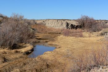
Amargosa River at Tecopa, California
|
|
|
Location of the mouth of the Amargosa River in California
|
|
| Country | United States |
| State | Nevada, California |
| County | Nye, San Bernardino, and Inyo |
| Physical characteristics | |
| Main source | Pahute Mesa Oasis Valley, Nye County, Nevada 3,964 ft (1,208 m) 37°04′20″N 116°41′19″W / 37.07222°N 116.68861°W |
| River mouth | Death Valley Badwater Basin, Inyo County, California −279 ft (−85 m) 36°14′37″N 116°51′24″W / 36.24361°N 116.85667°W |
| Length | 185 mi (298 km) |
| Basin features | |
| Basin size | 5,500 sq mi (14,000 km2) |
| Type: | Wild, Scenic, Recreational |
| Designated: | March 30, 2009 |
The Amargosa River is a special waterway, about 185 miles (298 km) long. It flows through southern Nevada and eastern California in the United States. This river drains a high desert area called the Amargosa Valley and Amargosa Desert. It then moves into the Mojave Desert and finally reaches Death Valley. There, it disappears into an underground aquifer, which is like a natural underground water storage.
Most of the time, the Amargosa River flows underground. You can only see it above ground after a big rainstorm. However, there are a few places where it always flows on the surface. These include parts of the Amargosa Canyon in California and a small section near Beatty, Nevada. A 26-mile (42 km) part of the river, between Shoshone and Dumont Dunes, is protected. It is known as a National Wild and Scenic River. Also, the Amargosa River Natural Area helps protect the plants and animals living near the river in the Tecopa Valley.
Contents
River's Journey: Where Does the Amargosa Flow?
Most of the Amargosa River's path is dry on the surface. This changes only during flash floods, which happen after heavy rain. The water usually flows underground. But you can see it above ground near Beatty and Tecopa, California, especially in the Amargosa Canyon. In this canyon, the river creates a green area with lots of wildlife. This is because water is present there.
Starting Point in Nevada
The river begins in Nye County, Nevada, about 3,900 feet (1,189 meters) above sea level. Its source is along the southern side of Pahute Mesa. This area is part of the Nevada Test and Training Range. Thirsty Canyon Wash joins the river at its start. When there's water, the river flows southwest into Oasis Valley.
The river runs next to U.S. Route 95. It passes near the Bullfrog Hills on its right side. It then gets water from Sober-Up Gulch on the right and Beatty Wash on the left.
Through Beatty and Into the Desert
About 3 miles (5 km) downstream, the river flows through Beatty. It then turns south-southeast and goes through the Amargosa Narrows. After this, it enters the Amargosa Desert. Here, Bare Mountain is on the left. The Grapevine and Funeral Mountains are on the right. These are part of the Amargosa Range.
Further downstream, the river still runs near Route 95. It passes Big Dune on its left. Soon after, it goes by the town of Amargosa Valley on the left. Then, it leaves Nevada and enters Inyo County, California. In this part, Forty Mile Wash adds water to the river from the left.
Journey Through California
The river continues, running roughly parallel to California Route 127. It passes through Death Valley Junction. Soon, Carson Slough joins it from the left. Carson Slough drains water from the Ash Meadows National Wildlife Refuge.
The river then flows between the Resting Spring Range on the left and the Greenwater Range on the right. After this, it reaches Shoshone. Below Shoshone, the river keeps going near Route 127 to Tecopa.
Amargosa Canyon and Death Valley
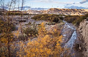
Downstream from Tecopa, the river follows the Old Spanish Trail. It flows through the Amargosa Canyon. The Sperry Hills are on the right, and the Dumont Hills are on the left. The river then enters San Bernardino County, California. It passes by Dumont Dunes in the northern Mojave Desert.
The river then turns west and goes under Route 127. It enters Death Valley National Park. Here, it flows between the southern end of the Amargosa Range on the right and the Avawatz Mountains on the left.
Final Stretch to Badwater Basin
Turning northwest and then north, the river goes back into Inyo County. It flows between the Owlshead Mountains on the left and the Ibex Hills on the right. Confidence Wash and Rhodes Wash both join it from the right.
In this area, the river runs near Harry Wade Road and, further north, California Route 178. The river receives Willow Creek from the right. It finally ends in Badwater Basin, which is about 279 feet (85 meters) below sea level. This basin is between the Black Mountains on the right and the Panamint Range on the left. The river disappears into the ground here. It feeds the underground water supply that is left over from an ancient lake called Lake Manly.
How Much Water Flows?
The United States Geological Survey (USGS) measures the river's flow. They have a measuring station near the Old Spanish Trail Road, about 0.2 miles (0.3 km) west of Tecopa. At this station, the river's average flow is about 3.80 cubic feet per second (0.108 cubic meters per second).
This measurement comes from a drainage area of 3,090 square miles (8,003 square kilometers). This area is about 60 percent of the Amargosa River's total drainage basin. Much of this area does not add water to the river. The most water ever recorded there was 10,600 cubic feet per second (300 cubic meters per second) on August 16, 1983. On some days in some years, no water was recorded at all.

River's Past: A Look at Amargosa History
The name of the river comes from the Spanish word amargo, which means "bitter." It likely came from agua amargosa, meaning "bitter water." This name was first written down in 1844. It probably refers to the salty water found in the river.
The Amargosa River is a very old stream. It flows through a canyon that has been there for a very long time. People have lived along this river for more than 10,000 years. Besides the ancient Lake Manly in Death Valley, the middle part of the river valley was covered by another ancient lake. This lake was called Lake Tecopa and existed during the late Pleistocene Ice Age.
Human Connections to the River
Along the Amargosa Range, the canyon floor has remains of old homes from native people. The Bureau of Land Management helps protect these sites. In the 1800s, the Old Spanish Trail followed the river's path through the Amargosa Canyon.
From 1907 to 1941, a train line called the Tonopah and Tidewater Railroad also followed the lower part of the river. This train helped connect faraway communities in Death Valley.
In March 2009, a 26-mile (42 km) section of the river became protected. This part is between Shoshone and Dumont Dunes. It was named a Wild and Scenic River as part of a special law.
 | George Robert Carruthers |
 | Patricia Bath |
 | Jan Ernst Matzeliger |
 | Alexander Miles |


