
Badwater Basin facts for kids
Quick facts for kids Badwater Basin |
|
|---|---|
 |
|
| Location | Death Valley California |
| Coordinates | 36°14′24″N 116°49′54″W / 36.23998°N 116.83171°W |
| Type | Endorheic basin |
| Primary inflows | Amargosa River |
| Primary outflows | Terminal (evaporation) |
| Basin countries | United States |
| Settlements | Badwater, California |
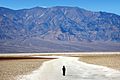
Badwater Basin is a special place in Death Valley National Park, California. It's a type of landform called a basin. This means it's a low area where water collects but doesn't flow out to the ocean.
Badwater Basin is famous because it's the lowest point in North America! It sits 282 ft (86 m) below sea level. Imagine, Mount Whitney, the tallest mountain in the 48 states, is only 76 miles away.
There's a small pool of water here that comes from a spring. It's called 'Badwater' because you can't drink it. Why? Because so much salt has collected in the basin over time. Even though it's salty, some amazing plants and animals live in the pool, like pickleweed, insects, and a special snail called the Badwater snail.
The actual lowest spot in the basin isn't right at the pool. It's a few miles to the west, and its exact location can change. However, the salt flats are tricky to walk on. So, the sign for the lowest point is placed at the pool, where everyone can easily see it. Some people think Badwater Basin is the lowest point in the Western Hemisphere, but that's not quite right. The lowest point there is Laguna del Carbón in Argentina.
Contents
How Badwater Basin Was Formed


Sometimes, big rainstorms hit Death Valley. When this happens, the bottom of the valley fills with a thin layer of water. This creates temporary lakes on the salt flats. But these lakes don't last long. Death Valley gets only about 1.9 inches (48 mm) of rain each year. However, about 150 inches of water evaporate every year! This means even a very deep, long lake would dry up in just one year.
When the basin is flooded, some of the salt dissolves into the water. As the water evaporates, the salt turns back into clean crystals. This process helps create the unique salt formations you see.
High up on the cliff above Badwater, there's a sign that says "Sea Level". It's a popular spot for visitors to look at and imagine how far below sea level they are.
A Look Back in Time
Long ago, during a time called the Holocene, the weather in this area was much wetter. Streams flowing from the mountains slowly filled Death Valley. It became a huge lake, about 3 feet (1 meter) deep and 80 mi (130 km) long! This ancient lake is known as Lake Manly.
But the wet times didn't last. The temperature got warmer, and there was less rain. Lake Manly began to dry up. As the water evaporated, the lake became super salty. Eventually, all that was left was a thick, salty liquid called brine. The salts, mostly common table salt (NaCl), started to form crystals. These crystals created a thick crust on the surface, from three inches to five feet thick.
Pictures of Badwater Basin
-
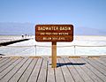
The sign showing Badwater Basin's elevation
-
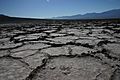
Salt crust shaped like honeycombs
-
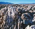
Salt formations at Devil's Golf Course
-
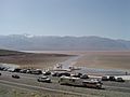
The tourist area flooded by Lake Badwater in 2005


More Images
-
A wide view of the basin's salt flats
-
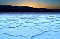
Close-up of the hexagonal salt crust


See also
 In Spanish: Cuenca Badwater para niños
