
Lake Manly facts for kids
Quick facts for kids Lake Manly |
|
|---|---|
| Lake Manley [sic], Death Valley Lake, Death Valley Pleistocene Lakes |
|

Lake Manly occasionally reforms after strong precipitation
|
|
| Lua error in Module:Location_map at line 420: attempt to index field 'wikibase' (a nil value). | |
| Location | Death Valley, California |
| Type | Pluvial lake |
| Etymology | After William Lewis Manly |
| Part of | Death Valley system, Great Basin |
| Primary inflows | Amargosa River, Mojave River and Owens River at various points of time. Springs |
| Primary outflows | Unlikely, possibly Colorado River |
| Catchment area | 65,806 square kilometres (25,408 sq mi) |
| Max. length | 140 kilometres (90 mi) |
| Max. width | 9.7–17.7 kilometres (6–11 mi) |
| Surface area | About 1,600 square kilometres (620 sq mi) |
| Average depth | Up to 335 metres (1,099 ft) |
| Water volume | 176 cubic kilometres (42 cu mi) |
| Shore length1 | 320 kilometres (200 mi) |
| Surface elevation | 47–90 metres (154–295 ft) |
| 1 Shore length is not a well-defined measure. | |
Lake Manly was a huge ancient lake in Death Valley, California. It was a "pluvial lake," meaning it formed during times when the climate was much wetter than today. This happened during past ice ages. At its largest, Lake Manly covered about 1,600 square kilometres (620 sq mi) of Death Valley.
The lake's water levels changed a lot over time. Its main water sources were the Amargosa River, and sometimes the Mojave River and Owens River. This large lake system helped many water animals, like certain lizards, pupfish, and snails, to spread across the region. Lake Manly was home to a thriving ecosystem with many tiny living things called diatoms.
Lakes have existed in Death Valley at different times in the past. The biggest Lake Manly formed about 185,000 to 128,000 years ago. This was during a cold period called the Tahoe glacial stage. After this huge lake dried up, a smaller lake formed between 35,000 and 10,000 years ago. Today, Death Valley is very dry. Only small, temporary lakes appear after very heavy rains.
Lake Manly was one of many large lakes in the Great Basin area. Other famous ones include Lake Lahontan and Lake Bonneville. These lakes formed because temperatures were lower during the ice ages. This meant less water evaporated. Also, there was more rain and snow. Lake Manly collected water from many other lakes, like Owens Lake and Lake Mojave.
Contents
Discovering Ancient Lake Manly
Scientists first thought about large ancient lakes in the Great Basin in the late 1800s. They had already found evidence for lakes like Lahontan and Bonneville. People wondered if Death Valley also had a past lake.
Early Clues to a Hidden Lake
At first, not everyone believed a big lake existed in Death Valley. But in 1924, geologist Levi F. Noble found the first clear proof. Even earlier, in 1890, another geologist named Grove Karl Gilbert guessed there was a lake. His idea was for a much bigger lake than what was actually found.
What Evidence Did Scientists Find?
Scientists found several clues that Lake Manly once existed. They saw "wavecut terraces," which are like old shorelines carved into the land by waves. They also found pebbles, a type of rock called tufa, and layers of clay and salt on the old lake bed. Deposits of calcium carbonate, likely made by tiny algae, were also found. These clues are scattered across Death Valley.
At first, scientists thought all these deposits came from one single lake period. But later, they found evidence of many different lake cycles. Some went back as far as the Pliocene epoch. The story of Lake Manly is not as well known as that of Lake Lahontan or Lake Bonneville.
How Lake Manly Got Its Name
The lake was named after William Lewis Manly. He was a brave person who helped rescue immigrants from Death Valley in 1849. The name "Lake Manly" was first used in 1932. Sometimes it is spelled "Manley," but that is a mistake. Other old names for lakes in Death Valley include "Death Valley Pleistocene lakes" and "Death Valley Lake."
The name "Lake Manly" is used for all the lakes that filled Death Valley in the past. But sometimes, it refers only to the most recent large lake stages.
Where Lake Manly Was Located

Lake Manly formed in Death Valley, which is a deep valley created by Earth's movements. Mountains surround it on all sides. These include the Cottonwood Mountains and Panamint Range to the west. To the south are the Owlshead Mountains. To the east are the Black Mountains, Funeral Mountains, and Grapevine Mountains.
Death Valley is about 200 kilometres (120 mi) long and 10–30 kilometres (6–19 mi) wide. It has three main low areas, with Badwater Basin being the deepest. Badwater Basin is the lowest point in North America, at 86 metres (282 ft) below sea level. Death Valley started forming about 14 million years ago. It stays deep because the ground keeps sinking faster there than almost anywhere else in the U.S.
Earth's Moving Surface
Death Valley is an area where the Earth's crust is very active. There are many faults, which are cracks in the Earth where rocks move. Because of these faults, old shorelines from the same lake level are often found at different heights in different parts of the valley. This makes it tricky to figure out the exact depth of Lake Manly. The ground in Death Valley is still sinking today.
The Size and Shape of Lake Manly
Lake Manly was a long, narrow lake. It had a smaller southern part called "Confidence Flats." At its highest level, the lake was about 181–184 metres (595–605 ft) deep. It was about 9.7–17.7 kilometres (6–11 mi) wide and 140 kilometres (90 mi) long. The total length of its shores was about 320 kilometres (200 mi).
The most noticeable shoreline, about 90 metres (300 ft) high, is called the "Blackwelder shoreline." At this level, the lake covered about 1,600 square kilometres (620 sq mi). Its total volume would have been about 176 cubic kilometres (42 cu mi).
Islands and Shorelines
Lake Manly had at least one island near Beatty Junction. There were two more islands at Shoreline Butte in the southern part of the lake. The northern base of the Avawatz Mountains might have been a peninsula (land almost surrounded by water) on the southern shore.
Scientists have found many landforms created by Lake Manly's waves. These include spits (sandbars extending from the shore) and barrier bars. At Desolation Canyon, they found spits and a tombolo (a sandbar connecting an island to the mainland). The "Manly Terraces" are a group of large terraces just south of Desolation Canyon. At least 12 different terraces have been found at Shoreline Butte.
Waves on Lake Manly mostly came from the north-northwest. This pushed sand and rocks to the south. This is why most of the old shore features are on the eastern side of the lake. These areas were most exposed to the waves.
How Lake Manly Got Its Water

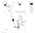
The size of lakes like Lake Manly depends on how much water flows in and how much evaporates. So, the lake's surface level can tell us about past climates. Lake Manly got most of its water from the Amargosa River, the Mojave River, and the Owens River. These rivers formed a huge water system across the southwestern Great Basin. The area that drained into Lake Manly was about 65,806 square kilometres (25,408 sq mi). However, it's likely that these three rivers did not all flow into Lake Manly at the same time.

Main Rivers Feeding the Lake
The Amargosa River was the main river flowing into Lake Manly. It used to end in Lake Tecopa. It only started reaching Death Valley more recently, perhaps between 600,000 and 18,000 years ago.
The Mojave River might have connected to the Amargosa River and then flowed into Lake Manly. This probably happened only during very wet periods. It also happened after other lakes like Lake Manix and Lake Mojave overflowed. Today, the Mojave River almost reaches Death Valley. If Lake Mojave fills up with sediment, its water could reach Death Valley even now.
The Owens River also flowed into Lake Manly, at least during the Tahoe glaciation. This river system formed 3.2 million years ago. It filled up Owens Lake, Searles Lake, and the Panamint Valley before reaching Lake Manly. More rain and snow, and less evaporation, allowed water to flow from one lake to the next. When Lake Panamint was deep enough, it spilled over a pass called Wingate Pass into Lake Manly.
Connecting to Other Water Systems
These rivers also received water from other ancient lakes. For example, Lake Pahrump drained into the Amargosa River. Lake Russell (now Mono Lake) connected to the Owens River. This connection was important for animals. It allowed fish like minnows and suckerfish to spread between different water systems.
There's also evidence that Lake Manly might have connected to the Colorado River. This could have happened through the Amargosa River or an older path of the Mojave River. Overall, this created a huge network of connected lakes. The amount of water flowing into Lake Manly was at least 3.5 times more than today.
Local Water Sources
Other water came from streams in the Amargosa Mountains and the Panamint Mountains. This water came from melting snow. Today, the main water sources are Salt Creek and many springs around the valley. These springs contribute a lot of the water in Death Valley today.
Springs also added water to Lake Manly, especially when the lake was first forming. They helped keep the water levels steady. In turn, Lake Manly would have affected the local underground water levels.
Was There an Outlet?
Early scientists thought Lake Manly had no outlet. They believed its water level was only controlled by how much water flowed in and how much evaporated. However, finding fossil pupfish suggests that the lake might have connected to the Colorado River in the past. This connection probably ended about 3 to 2 million years ago.
It's a big question whether Lake Manly ever drained into the Colorado River. Some ideas suggest it might have flowed over a high pass near Ludlow, California. Then it would have gone through several other lakes before reaching the Colorado River. But most scientists think a connection between Lake Manly and the Colorado River more recently than 3 million years ago is unlikely.

What Was Lake Manly's Water Like?
Because Lake Manly had no constant outlet, it was naturally a saltwater lake. But when the lake was at its highest, the water would have been less salty. The water was probably less salty in the southern parts of the lake, where most of the fresh water flowed in.
During dry periods, salt built up in the valley. The lake's saltiness usually did not go above 10,000 parts per million (ppm). Sometimes it was even less than 3,000 ppm. This is known from studying tiny creatures called ostracods found in the lake deposits.
The water also had a lot of calcium. This came from calcium-rich springs connected to underground melted rock (magma) in southern Death Valley.
Climate Around Lake Manly
Death Valley today is very hot and dry. The average yearly temperature is about 26 °C (79 °F). July temperatures are usually over 38 °C (100 °F). But during the time of Lake Manly, the climate was much cooler.
Cooler Temperatures and More Rain
During the ice ages, summer temperatures around Lake Manly were about 6–8 °C (11–14 °F) lower than today. Winters were milder in the middle altitudes. Winter water temperatures in the lake might have dropped below 10 °C (50 °F), sometimes even below freezing.
Death Valley is dry because mountains like the Panamint Range and Sierra Nevada block rain clouds. This creates a "rain shadow." Today, less than 50 millimetres (2.0 in) of rain falls each year. But during the time of Lake Manly, rainfall was three or four times higher. To make a lake as big as Lake Manly's last highstand, temperatures would have needed to drop by about 10 °C (50 °F) and rainfall would have needed to be 2.5 times higher than today.
Windy Conditions
Lake Manly was probably much windier than Death Valley is today. Strong winds were needed to move some of the rocks found along the lake's shores. Wind speeds of about 14–27 metres per second (46–89 ft/s) were likely common. The valley's shape would have created strong northerly winds. But strong southwesterly winds also helped form the beach deposits.
Waves on the lake were estimated to be about 76–94 centimetres (2 ft 6 in – 3 ft 1 in) high. Waves of about 1.35–2.22 metres (4 ft 5 in – 7 ft 3 in) were needed to move beach material. Wave activity was strongest in the southern and northern parts of Lake Manly.
Life in and Around Lake Manly
Scientists can guess what life was like in Lake Manly by looking at similar lakes today. They also study the streams that flow into Death Valley. Finding the same species in different places helps scientists understand how water systems were connected. For example, if fish from the Colorado River are found in Lake Manly, it suggests a past connection. Birds might also have carried animals between different water areas.
Tiny Life Forms in the Lake
Some rock deposits called tufa were formed by tiny blue-green algae. These included charophytes. Tiny crustaceans called Ostracods also lived in Lake Manly. Different species of ostracods, like Candona caudata and Limnocythere staplini, have been found. Stromatolites, which are layered rock structures made by microbes, were active in ponds behind the lake's beaches.
Larger Animals in the Water
Larger animals that probably lived in the lake included brine fly larvae, brine shrimp, and molluscs (like snails and clams). Today, unique water animals in Death Valley include amphipods and springtails. The connected river system may have helped spread the spider Saltonia incerta.
Nineteen different types of Tyronia springsnails live in the Lake Manly system. This suggests an early connection between the Amargosa River and the Colorado River.
Fish of Lake Manly
Much research has been done on the fish of Death Valley. About 24 species have been found. Minnows and the desert pupfish likely lived in Lake Manly. The Lake Manly drainage system helped these fish spread across the region. After the lake dried up about 10,000 years ago, different pupfish species evolved. This happened because their populations became separated.
Pupfish may have entered Death Valley through the Owens River. They might have formed one large breeding group. The different species of pupfish we see today probably evolved in just a few thousand years after Lake Manly dried up. Cyprinodon fish have been in Death Valley since the late Miocene-early Pliocene.
Plants and Animals on the Shores
The shores of Lake Manly supported many bird populations. Mountain slopes were probably covered with sagebrush. Higher up, there were forests of juniper and pine trees. During the ice ages, forests grew at much lower altitudes than they do today. Fossils of shadscale and yucca plants have been found at even lower elevations.
Lizards of the genus Uma are often found near old river and lake systems. This suggests these water systems helped them spread. One group of Uma scoparia lizards is linked to the Lake Manly system. The California vole (a small rodent) also spread between the Mojave River and Amargosa River systems because of Lake Manly.
Early Human Activity
Freshwater lakes would have been good places for early humans to live. Scientists have found tools that might have been made by humans on the Manly Terrace. These include scrapers, gravers, and some drills and blades. This human activity likely happened when Lake Manly was at its highest level, during the Wisconsin glaciation. However, some people question if these artifacts were truly made by humans, as they look like natural rocks.
When Lake Manly Existed
Lake Manly existed during the late Pleistocene epoch. At first, scientists thought it only existed during one cold period. But later, evidence from drilling cores showed two main lake stages.
Two Main Lake Stages
The first big lake stage was about 185,000 to 128,000 years ago. The second stage was about 35,000 to 10,000 years ago. Between 120,000 and 60,000 years ago, there was no lake in Death Valley. Then, separate salty lakes existed between 60,000 and 35,000 years ago.
The Blackwelder Highstand
The highest shoreline, found at about 90–100 metres (300–330 ft) elevation, is called the Blackwelder stand. It belongs to the first big lake stage. This shoreline formed about 186,000 to 120,000 years ago. During this time, the Amargosa River and Owens River both flowed into Lake Manly.
Depending on how fast the ground was sinking, the lake at this early stage could have been 175 metres (574 ft) and up to 335 metres (1,099 ft) deep. Fossils of ostracods from this time show that the lake's conditions changed.
Later Lake Stages and Drying Up
By 130,000–120,000 years ago, Lake Manly had shrunk from its Blackwelder highstand. A later lake stage happened during the Wisconsin glaciation. This lake was not as large as the Blackwelder lake. It was shallower, with estimated depths of 64–78 metres (210–256 ft). This later lake might have even been split into two separate bodies of water.
The last big lake stage, during the last glacial maximum, covered about 1,600 square kilometres (620 sq mi). This lake had high water levels around 26,000, 18,000, and 12,000 years ago.
Death Valley Today

By 12,000 years ago, Lake Manly had shrunk to just the Badwater basin. It was probably only about 2 metres (6 ft 7 in) deep. This drying event separated different pupfish populations. This led to the evolution of unique species in small, isolated areas. The lake likely dried up very quickly.
The lake had completely disappeared by 10,000 years ago. Today, only a small pond remains in Badwater basin. The rest of the valley floor is covered in mudflats and salt pans. Only Salt Creek and some springs provide fresh water. The Mojave River's floodwaters usually disappear before reaching Death Valley. The current climate in Death Valley is too hot and dry for permanent lakes to exist.
However, parts of Death Valley sometimes flood during very wet weather. This causes parts of Lake Manly to temporarily reappear. For example, severe flooding in March 2005 caused parts of Death Valley to become submerged. This event broke rainfall records and led to a huge "desert bloom" of wildflowers. These temporary lake refillings often happen during El Niño weather events.
Images for kids
-
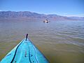
Lake Manly occasionally reforms after strong precipitation
-
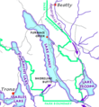
The drainage system of Lake Manly; present-day roads are shown for reference.
-
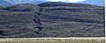
Shoreline Butte, close with shorelines visible
-
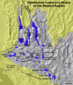
Lacustrine system of the Mojave Desert
-
The Owens River-Lake Manly system
-
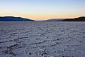
Salts left behind by Lake Manly, in Badwater Basin
-
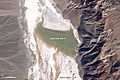
A reformed lake in 2005
