Grapevine Mountains facts for kids
Quick facts for kids Grapevine Mountains |
|
|---|---|

Grapevine Mountains
|
|
| Highest point | |
| Peak | Grapevine Peak |
| Elevation | 2,664 m (8,740 ft) |
| Geography | |
| Country | United States |
| State | California and Nevada |
| District | Inyo County and Nye County |
| Range coordinates | 36°57′54.778″N 117°8′57.242″W / 36.96521611°N 117.14923389°W |
| Topo map | USGS Grapevine Peak |
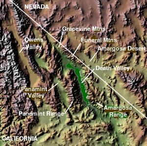
The Grapevine Mountains are a cool mountain range found right on the border between California and Nevada in the United States. These mountains stretch for about 22 miles (35 km) and run from the northwest to the southeast. They are a big part of the amazing Death Valley National Park.
Contents
About the Grapevine Mountains
The Grapevine Mountains are a natural border between two states. They are located in Inyo County, California, and Nye County, Nevada. This makes them a unique spot to explore.
Where are they?
This mountain range is quite long, reaching about 22 miles (35 km). It runs in a specific direction, from the northwest to the southeast. You can find them right along the state line that separates Nevada and California.
What's in a Name?
The Grapevine Mountains got their name from something special found in the area. Long ago, people discovered wild grapes growing there. These grapes were so common that they inspired the name for the entire mountain range!
High Points and Passes
The highest point in the range is Grapevine Peak. This peak stands tall at 8,738 feet (2,663 m) and is located on the Nevada side, near a place called Phinney Canyon. At the southern end of the mountains, you'll find Daylight Pass. This pass is a well-known spot in the area.
Part of Death Valley
A really important fact about the Grapevine Mountains is that most of them are inside Death Valley National Park. This park is famous for its extreme temperatures and unique landscapes. Being part of the park means the mountains are protected and offer incredible views and habitats for wildlife.
 | Madam C. J. Walker |
 | Janet Emerson Bashen |
 | Annie Turnbo Malone |
 | Maggie L. Walker |


