Death Valley National Park facts for kids
Quick facts for kids Death Valley National Park |
|
|---|---|
|
IUCN Category II (National Park)
|
|
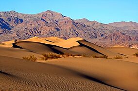
Sand dunes in Death Valley National Park
|
|
| Location | California and Nevada, United States |
| Nearest city | Lone Pine, California Beatty, Nevada |
| Area | 3,422,024 acres (13,848.44 km2) |
| Established | February 11, 1933 as a national monument October 31, 1994 as a national park |
| Visitors | 1,128,862 (in 2022) |
| Governing body | National Park Service |
Death Valley National Park is a special place in the United States. It sits right on the border between California and Nevada. This park is unique because it combines parts of two deserts: the Great Basin and the Mojave Desert. Here, you can find amazing landscapes like flat areas covered in salt, huge sand dunes, rocky badlands, deep valleys, narrow canyons, and tall mountains.
Death Valley is the largest national park in the main part of the United States. It's also known for being the hottest, driest, and lowest place among all U.S. national parks. Inside the park is Badwater Basin, which is 282 feet (86 meters) below sea level. This makes it the lowest point in all of North America! Most of the park, over 93%, is a protected wilderness area.
Many plants and animals live here, even though the desert is very harsh. They have learned to survive in this tough environment. Some examples are the creosote bush, Joshua tree, bighorn sheep, coyote, and the rare Death Valley pupfish. The pupfish is a tiny fish that survived from a time when the valley had much more water. In 1984, UNESCO recognized Death Valley as a key part of the Mojave and Colorado Deserts Biosphere Reserve.
People have lived in this area for a very long time, starting around 7000 BC. The most recent Native American group, the Timbisha, arrived about 1000 AD. They moved between the valleys in winter and the mountains in summer. The name "Death Valley" came from a group of European-Americans who got lost here in 1849 while looking for a shortcut to the gold fields. Even though only one person in their group died, they gave the valley its dramatic name.
In the late 1800s and early 1900s, some small mining towns popped up to find gold and silver. But the most successful mining was for borax. This mineral was carried out of the valley by famous "twenty-mule teams." Later, Death Valley became famous in books, radio shows, and movies. More and more tourists started visiting in the 1920s, and resorts were built. Death Valley became a national monument in 1933 and then a national park in 1994.
The park's natural features are mostly shaped by its geology. The valley is a graben, which means it's a sunken block of land between two faults. The oldest rocks here are incredibly old, about 1.7 billion years. Over millions of years, the land has been uplifted, pulled apart, and filled with sediments and ancient lakes.
Death Valley is the fifth-largest national park in the U.S. and the biggest in the main part of the country. It's even larger than the states of Rhode Island and Delaware combined! In 2013, it was named a dark sky park, meaning it's a fantastic place to see the stars.
Contents
Exploring Death Valley's Geography
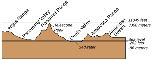
The park has two main valleys: Death Valley and Panamint Valley. Both formed over the last few million years. They are surrounded by mountain ranges that run north to south. These valleys are part of a larger area called the Basin and Range region. Here, the Earth's crust is pulling apart, causing some areas to rise into mountains and others to sink into valleys.
The mountains around Death Valley are rising very quickly. This means that the fan-shaped piles of dirt and rocks at the bottom of the canyons, called alluvial fans, are steep and small.
Badwater Basin: North America's Lowest Point
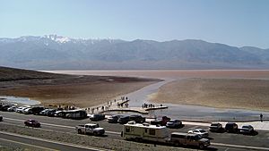
At 282 feet (86 meters) below sea level, Badwater Basin is the lowest spot in Death Valley. It's the second-lowest point in the entire Western Hemisphere! Just 85 miles (137 km) to the west, Mount Whitney rises to 14,505 feet (4,421 meters). This huge difference in height is the biggest in the main United States.
Because water used to collect here in ancient times, the valley floor is covered in huge salt pans. These salt flats are rich in minerals like borax. The largest salt pan in the park stretches for 40 miles (64 km). Another famous flat area is the Racetrack Playa, known for its mysterious "moving rocks."
Death Valley's Extreme Climate
Death Valley has a hot desert climate. It's the hottest and driest place in North America. This is because it has very little surface water and is so low. It's so often the hottest spot in the U.S. that weather reports sometimes don't even include it!
On July 10, 1913, the temperature reached an incredible 134°F (56.7°C) at Furnace Creek. This is the highest air temperature ever recorded on Earth! Summer temperatures often go above 120°F (49°C). Even in winter, nights can be below freezing. July is the hottest month, with an average high of 117°F (47°C). December is the coldest, with an average high of 66°F (19°C).
Some of the larger springs in Death Valley get their water from a huge underground water source called an aquifer. This water has been there for thousands of years, from the last ice ages when the climate was cooler and wetter. Today, not enough rain falls to refill this aquifer as fast as water is used.
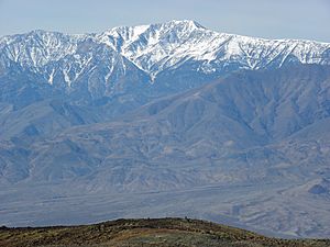
The highest mountains in the park are the Panamint Range. Telescope Peak is the tallest point at 11,049 feet (3,368 meters). Death Valley is surrounded by five mountain ranges. Three of them, the Sierra Nevada, the Argus Range, and the Panamint Range, block most of the moisture from the Pacific Ocean. This creates a strong rainshadow effect, making Death Valley extremely dry.
The park gets only about 1.5 inches (38 mm) of rain each year at Badwater. Some years, it gets no measurable rain at all! When it does rain, it often comes in strong storms. These storms can cause flash floods that change the landscape and sometimes create temporary, shallow lakes.
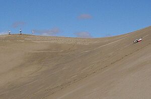
The hot, dry climate makes it hard for soil to form. So, rocks and dirt often slide down mountain slopes. The famous sand dunes in the park are not as common as you might think. The Mesquite Flat dune field is easy to visit near Stovepipe Wells. Other dune fields, like those in Eureka Valley, are much taller but harder to reach.
Sometimes, the park gets unusually wet weather. In 2005, a very wet winter created a temporary "lake" in Badwater Basin. This led to the most amazing wildflower season in the park's history! In 2015 and 2022, heavy rains caused major flooding and damage to roads.
| Climate data for Death Valley National Park, California, 1991–2020 normals, extremes 1911–present | |||||||||||||
|---|---|---|---|---|---|---|---|---|---|---|---|---|---|
| Month | Jan | Feb | Mar | Apr | May | Jun | Jul | Aug | Sep | Oct | Nov | Dec | Year |
| Record high °F (°C) | 90 (32) |
97 (36) |
103 (39) |
113 (45) |
122 (50) |
129 (54) |
134 (57) |
130 (54) |
127 (53) |
114 (46) |
98 (37) |
89 (32) |
134 (57) |
| Mean maximum °F (°C) | 78.4 (25.8) |
85.1 (29.5) |
95.4 (35.2) |
106.0 (41.1) |
113.6 (45.3) |
122.0 (50.0) |
125.9 (52.2) |
123.4 (50.8) |
118.1 (47.8) |
106.2 (41.2) |
90.0 (32.2) |
77.8 (25.4) |
126.7 (52.6) |
| Mean daily maximum °F (°C) | 67.2 (19.6) |
73.7 (23.2) |
82.6 (28.1) |
91.0 (32.8) |
100.7 (38.2) |
111.1 (43.9) |
117.4 (47.4) |
115.9 (46.6) |
107.7 (42.1) |
93.3 (34.1) |
77.4 (25.2) |
65.6 (18.7) |
92.0 (33.3) |
| Daily mean °F (°C) | 54.9 (12.7) |
61.3 (16.3) |
69.8 (21.0) |
77.9 (25.5) |
87.8 (31.0) |
97.5 (36.4) |
104.2 (40.1) |
102.3 (39.1) |
93.4 (34.1) |
78.9 (26.1) |
64.0 (17.8) |
53.4 (11.9) |
78.8 (26.0) |
| Mean daily minimum °F (°C) | 42.5 (5.8) |
49.0 (9.4) |
57.1 (13.9) |
64.8 (18.2) |
75.0 (23.9) |
84.0 (28.9) |
91.0 (32.8) |
88.7 (31.5) |
79.1 (26.2) |
64.4 (18.0) |
50.5 (10.3) |
41.1 (5.1) |
65.6 (18.7) |
| Mean minimum °F (°C) | 30.5 (−0.8) |
36.1 (2.3) |
42.8 (6.0) |
49.8 (9.9) |
58.5 (14.7) |
67.9 (19.9) |
78.3 (25.7) |
75.3 (24.1) |
65.4 (18.6) |
49.5 (9.7) |
35.9 (2.2) |
29.0 (−1.7) |
28.0 (−2.2) |
| Record low °F (°C) | 15 (−9) |
20 (−7) |
26 (−3) |
35 (2) |
42 (6) |
49 (9) |
62 (17) |
65 (18) |
41 (5) |
32 (0) |
24 (−4) |
19 (−7) |
15 (−9) |
| Average precipitation inches (mm) | 0.37 (9.4) |
0.52 (13) |
0.25 (6.4) |
0.10 (2.5) |
0.03 (0.76) |
0.05 (1.3) |
0.10 (2.5) |
0.10 (2.5) |
0.20 (5.1) |
0.12 (3.0) |
0.10 (2.5) |
0.26 (6.6) |
2.20 (56) |
| Average precipitation days (≥ 0.01 in) | 2.4 | 2.9 | 2.0 | 1.1 | 0.9 | 0.3 | 1.1 | 0.9 | 0.8 | 1.1 | 0.9 | 1.6 | 16.0 |
| Source: NOAA | |||||||||||||
| Climate data for Death Valley (Cow Creek Station) | |||||||||||||
|---|---|---|---|---|---|---|---|---|---|---|---|---|---|
| Month | Jan | Feb | Mar | Apr | May | Jun | Jul | Aug | Sep | Oct | Nov | Dec | Year |
| Record high °F (°C) | 84 (29) |
89 (32) |
100 (38) |
110 (43) |
120 (49) |
125 (52) |
126 (52) |
125 (52) |
123 (51) |
111 (44) |
95 (35) |
84 (29) |
126 (52) |
| Mean daily maximum °F (°C) | 64.4 (18.0) |
71.6 (22.0) |
80.6 (27.0) |
90.9 (32.7) |
100.0 (37.8) |
109.3 (42.9) |
116.0 (46.7) |
113.8 (45.4) |
106.9 (41.6) |
92.1 (33.4) |
75.4 (24.1) |
65.9 (18.8) |
90.6 (32.6) |
| Daily mean °F (°C) | 52.5 (11.4) |
59.1 (15.1) |
67.4 (19.7) |
77.5 (25.3) |
86.4 (30.2) |
95.3 (35.2) |
102.1 (38.9) |
99.9 (37.7) |
92.1 (33.4) |
78.1 (25.6) |
62.3 (16.8) |
54.1 (12.3) |
77.2 (25.1) |
| Mean daily minimum °F (°C) | 40.6 (4.8) |
46.6 (8.1) |
54.3 (12.4) |
64.1 (17.8) |
72.7 (22.6) |
81.2 (27.3) |
88.4 (31.3) |
86.0 (30.0) |
77.4 (25.2) |
64.0 (17.8) |
49.3 (9.6) |
42.4 (5.8) |
63.9 (17.7) |
| Record low °F (°C) | 19 (−7) |
30 (−1) |
33 (1) |
45 (7) |
52 (11) |
54 (12) |
69 (21) |
69 (21) |
57 (14) |
40 (4) |
32 (0) |
27 (−3) |
19 (−7) |
| Average precipitation inches (mm) | 0.24 (6.1) |
0.32 (8.1) |
0.20 (5.1) |
0.20 (5.1) |
0.10 (2.5) |
0.02 (0.51) |
0.10 (2.5) |
0.11 (2.8) |
0.12 (3.0) |
0.11 (2.8) |
0.20 (5.1) |
0.29 (7.4) |
2.00 (51) |
| Source: http://www.wrcc.dri.edu | |||||||||||||
A Look at Death Valley's Human History
Who Lived Here First?
Four different groups of Native Americans have lived in the Death Valley area over the last 10,000 years.
- The first group, the Nevares Spring People, were hunters and gatherers. They arrived about 9,000 years ago when small lakes still existed. The climate was milder then, and there were many large animals.
- Around 5,000 years ago, the Mesquite Flat People took their place.
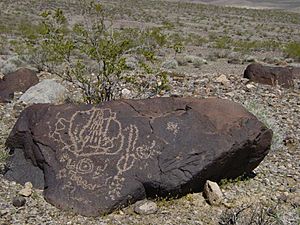
- About 2,000 years ago, the Saratoga Spring People moved in. By this time, the area was likely already a hot, dry desert. This group was skilled at hunting, gathering, and making crafts. They also left mysterious stone patterns.
One thousand years ago, the Timbisha (also called Shoshone) tribe came to the area. They hunted animals and gathered mesquite beans and pinyon pine nuts. Because the valley is so low and the mountains are so high, the Timbisha moved between different elevations. They spent winters in the warm valleys near water. As spring and summer arrived, they moved higher up the mountains to find ripening plants and pine nuts. In November, they were at the very top of the mountains before returning to the valley for winter.
The Gold Rush and the Valley's Name
The California Gold Rush brought the first European-Americans to the area. In December 1849, two groups of travelers, with about 100 wagons, got lost in Death Valley. They thought it was a shortcut to the gold fields. This group, called the Bennett-Arcane Party, couldn't find a way out for weeks. They found fresh water but had to eat some of their oxen to survive. They cooked the meat using wood from their wagons. This spot is now called "Burnt Wagons Camp."
After leaving their wagons, they finally hiked out of the valley. As they left, one woman reportedly said, "Goodbye Death Valley." This is how the valley got its famous name. One of the travelers, William Lewis Manly, wrote a book about their journey, which made the area well-known.
Mining Booms and Borax Teams
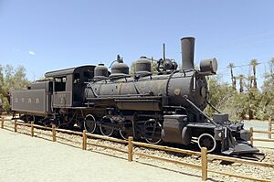
The most famous and profitable minerals found here were salts, borate (used to make borax), and talc. Borax was discovered in 1881. Soon after, the first borax mining operations began. William Tell Coleman built the Harmony Borax Works plant, which processed borax from 1883 to 1888. This borax was used to make soap and for industrial purposes.
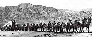
The finished borax was shipped out of the valley on a 165-mile (266 km) journey to the Mojave train station. Huge wagons, pulled by "twenty-mule teams," carried 10 tons of borax at a time. These teams actually had 18 mules and two horses. They traveled about 2 miles (3 km) an hour, and a round trip took about 30 days. The famous brand Twenty-Mule-Team Borax was named after these teams. Their image was used in ads for Boraxo soap and the Death Valley Days radio and TV shows.
Mining continued, and by the late 1920s, Death Valley was the world's top source of borax. The borate minerals come from rocks that are four to six million years old.
People also came to search for and mine copper, gold, lead, and silver. But these mining efforts were difficult because the area was so remote and the desert was so harsh. In 1903, an Irish miner named Jack Keane accidentally found a huge amount of gold. This started a small, short-lived gold rush. Only a few mines, like the Keane Wonder Mine, found enough metal to be truly successful. Many other mining attempts quickly failed. The towns that grew around these mines thrived in the early 1900s but soon disappeared.
Early Tourism in Death Valley
The first tourist places in Death Valley were tent houses built in the 1920s near Stovepipe Wells. People came to resorts built around natural springs, believing they had healing powers. In 1927, the Pacific Coast Borax company turned its worker housing into a resort, creating the Furnace Creek Inn. As water was used for the resort, the nearby marshes began to shrink.
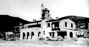
Soon, the valley became a popular winter vacation spot. Other places that started as private homes later opened to the public. The most famous was Death Valley Ranch, known as Scotty's Castle. This large home became a hotel in the late 1930s. It was popular because of the stories about Death Valley Scotty, whose real name was Walter Scott. He was a gold miner who pretended to own the "castle" and said he built it with gold profits. Neither was true, but the real owner, millionaire Albert Mussey Johnson, encouraged the story.
Protecting Death Valley
On February 11, 1933, President Herbert Hoover declared Death Valley and the surrounding area a national monument. This protected almost 2 million acres (8,000 square kilometers) of land.
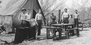
During the Great Depression, the Civilian Conservation Corps (CCC) built many important things in Death Valley. They built roads, water lines, telephone lines, and 76 buildings. They also created trails to scenic spots and built a village for the Timbisha tribe. Five campgrounds, restrooms, an airplane landing field, and picnic areas were also built.
When the monument was created, mining was temporarily stopped. But in June 1933, Congress allowed mining to start again. As mining technology improved, large open pit mines began to scar the landscape. This led to public outcry, and in 1976, Congress passed a law to protect national parks and monuments from new mining claims. The last mine in the park closed in 2005.
In 1952, President Harry Truman added Devils Hole to the monument. This is the only place where the rare Devils Hole pupfish lives.
Death Valley National Monument became a biosphere reserve in 1984. On October 31, 1994, the monument was made much larger and officially became a national park. This made it the largest national park in the main United States. In 2019, even more land was added to the park.
Today, cities near Death Valley, like Las Vegas, are growing very fast. This growth can affect the underground water sources that the park's plants and animals rely on.
In 1977, parts of Death Valley were used as a filming location for the movie Star Wars. It became the setting for the fictional planet Tatooine.
Understanding Death Valley's Geology
| Era | Rock Units/Formations | Principal Geologic Events |
|---|---|---|
| Cenozoic | Alluvial fans, stream, and playa deposits, dunes, numerous sedimentary, volcanic, and plutonic units in separate and interconnected basins and igneous fields (includes Artist Drive, Furnace Creek, Funeral, and Nova Formations). | Major unconformity, continued deposition in modern Death Valley, opening of modern Death Valley, continuing development of present ranges and basins, onset of major extension. |
| Mesozoic | Granitic plutons, Butte Valley | Thrust faulting and intrusion of plutons related to Sierra Nevada batholith; shallow marine deposition; unconformity. |
| Paleozoic | Resting spring Shale, Tin Mountain Limestone, Lost Burro, Hidden Valley Dolomite, Eureka Quartzite, Nopah, Bonanza King, Carrara, Zabriskie Quartzite, Wood Canyon. | Development of a long-continuing carbonate bank on a passive continental margin; numerous intervals of emergence, interrupted by deposition of a blanket of sandstone in Middle Ordovician time. Deposition of a wedge of silliciclastic sediment during and immediately following the rifting along a new continental margin. |
| Proterozoic | Crystalline basement, Pahrump, Stirling Quartzite, Johnnie, Ibex, Noonday Dolomite, Kingston Peak, Beck Spring, Crystal Spring. | Regional metamorphism, Major unconformity, rapid uplift and erosion, shallow marine deposition, glacio-marine deposition, unconformity. Shallow to deep marine deposition along an incipient continental margin. |
The park has a very interesting and complicated geologic history. Since it formed, the area has seen at least four big periods of volcanism (volcanic activity). It has also had three or four major periods where sediments were laid down. And the Earth's crust has been reshaped many times by plate tectonics. Even though no glaciers were ever in the park, two periods of ice ages also affected the area.
Ancient Rocks and Early Sediments
We don't know much about the oldest rocks here because they have been changed a lot by heat and pressure (this is called metamorphism). Scientists have used radiometric dating to find out that this change happened about 1.7 billion years ago. Later, about 1.4 billion years ago, a large mass of granite pushed into these rocks. Then, the land was lifted up, and these rocks were worn down by erosion for almost 500 million years.
After this, new layers of sediment, called the Pahrump Group, were laid down on top of these older rocks. These layers include rocky conglomerate and mudstone. Later, dolomite formed from ancient algal mats. The very youngest rocks in the Pahrump Group are from basaltic lava flows.
How the Pacific Ocean Formed Here
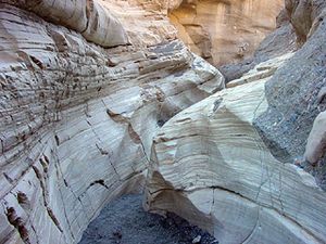
About 755 million years ago, a huge crack opened in the Earth's crust. This crack filled with water, creating the Pacific Ocean. This was part of the breakup of a supercontinent called Rodinia. A shoreline similar to the East Coast of the U.S. today was to the east. A layer of carbonate rock covered by algal mats formed, called the Noonday Dolomite. The land then sank as the continental crust got thinner and the Pacific Ocean grew wider. This formed the Ibex Formation. Then, there was a big gap in the rock record where no new rocks were formed.
A true ocean basin then developed to the west. This broke all the older rock layers along a steep edge. Layers of sediment then started to build up at the bottom of these underwater cliffs, forming new continental shelves. Three rock formations grew from these sediments. The first known fossils of complex life, like the Ediacara fauna and trilobites, are found in these rocks. The appearance of trilobites was part of the "Cambrian Explosion" of life.
About 550 million years ago, the sandy mudflats changed into a carbonate platform, similar to the Bahamas today. This lasted for the next 300 million years of Paleozoic time. Death Valley was then close to the equator. Thick layers of carbonate-rich sediments were laid down, but sometimes the land rose out of the water. These eight formations are 20,000 feet (6 km) thick and are found under many of the park's mountain ranges.
Mountains Rising and Lakes Forming
In the early to middle Mesozoic Era, the western edge of North America pushed against the oceanic plate under the Pacific. This created a subduction zone, where the heavier oceanic crust slid under the lighter continental crust. This process caused volcanoes to erupt and mountains to rise. The coastline moved westward. The Sierran Arc (a chain of volcanoes) began to form to the northwest.
After these events, there was a long period of uplift and erosion. This created a huge gap in the geologic record. Sediments from the Death Valley region were carried away by wind and water. No sedimentary rocks from the Jurassic to Eocene periods exist here, except for some possible Jurassic-age volcanic rocks.
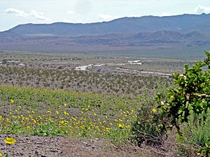
About 16 million years ago, the Earth's crust in the southwestern U.S. and northwestern Mexico began to stretch. This stretching started to affect the Death and Panamint valleys about 3 million years ago. Before this, the rocks that are now in the Panamint Range were on top of the rocks that would become the Black Mountains. Large blocks of crust moved sideways and up and down along faults. This stretching is still happening today.
Volcanic activity happened from 12 million to 4 million years ago because of this stretching. Sediments from the eroding mountains filled the valleys. The amount of sediment has kept up with the sinking of the valleys, so the valley floor has stayed at roughly the same height over time.
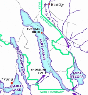
About 2 million years ago, the Pleistocene ice ages began. Meltwater from glaciers on the nearby Sierra Nevada Mountains filled a series of lakes in Death and Panamint valleys. The large lake that covered much of Death Valley's floor, called Lake Manly, started to dry up 10,500 years ago. As the ice age glaciers melted away, the lakes' water source disappeared, leaving behind the huge salt pans we see today. Only faint shorelines remain.
Wildlife and Plants of Death Valley

The habitat in Death Valley changes a lot, from the salt flats 282 feet (86 meters) below sea level to the high mountain peaks like Telescope Peak, which is 11,049 feet (3,368 meters) high. Different types of plants grow at different elevations. You'll find creosote bush, desert holly, and mesquite in the lower areas. Higher up, there's sage, Joshua tree, pinyon-juniper trees, and even bristlecone pine woodlands. The salt flats have no plants, and most of the valley floor has very few. But where water is available, plants are usually abundant.
These different areas support many kinds of wildlife. The park is home to 51 types of native mammals, 307 types of birds, 36 types of reptiles, 3 types of amphibians, and 2 types of native fish.
There are more small mammals than large ones. Some of the larger mammals include bighorn sheep, coyotes, bobcats, kit foxes, cougars, and mule deer. Bighorn sheep are rare mountain sheep that live in isolated groups in the Sierra and Death Valley. They can eat almost any plant and have no known predators, but humans and burros compete with them for food and space.
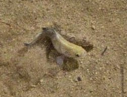
The ancestors of the Death Valley pupfish swam to this area from the Colorado River through a system of rivers and lakes that dried up long ago. Now, they live in two separate groups: one in Salt Creek and another in Cottonball Marsh. Death Valley is one of the hottest and driest places in North America, but it has over 1,000 types of plants. Twenty-three of these plants, like the very rare rock lady, are found nowhere else in the world.
Being able to survive in a dry environment is very important. For example, creosote bushes and mesquite trees have deep roots that can go down 50 feet (15 meters) to reach underground water all year. The variety of plants in Death Valley comes partly from its location. It's a transition zone between the Mojave Desert, the Great Basin Desert, and the Sonoran Desert. This, along with the huge differences in elevation, supports plants typical of three different climate zones.
Many of the water-dependent habitats in Death Valley have unique plant and animal species found nowhere else. These species exist because of the park's special geologic history and how life has changed in these isolated habitats since the Pleistocene epoch (Ice Age).
Things to Do in Death Valley
You can explore Death Valley by car, four-wheel drive vehicle, motorcycle, bicycle, mountain bike (on roads only), and by hiking. Main roads like State Route 190, Badwater Road, and the roads to Dante's View and Wildrose lead to major viewpoints and historic sites. There are also over 350 miles (563 km) of unpaved roads for wilderness hiking, camping, and visiting historical spots. Unlike many other national parks, there are no formal entrance gates. You can pay entry fees at visitor centers, ranger stations, or fee machines.
There are hiking trails of different lengths and difficulties. Most backcountry areas can only be reached by hiking off-trail. The best time to visit the park is from October to May, to avoid the extreme summer heat. Tours of the historic Scotty's Castle have been stopped since October 2015 due to flood damage. It is currently closed to the public.
The park has nine campgrounds. You can get permits for overnight backcountry camping at the visitor center. Xanterra Parks & Resorts runs a private resort called the Oasis at Death Valley. It has two hotels: the Inn at Death Valley (a historic four-star hotel) and the Ranch at Death Valley (a three-star hotel that looks like an old mining ranch). Panamint Springs Resort is in the western part of the park. The Stovepipe Wells Resort is also available. You can also find motels near the park entrances in Shoshone, Death Valley Junction, Beatty, and Pahrump.
The Furnace Creek Visitor Center is on CA-190. It has exhibits and a film about the park's geology, climate, wildlife, and history. From November to April, park rangers offer guided tours, talks, and presentations about Death Valley's culture and nature. The Death Valley Natural History Association also has a bookstore there.
The northeast part of Saline Valley has several hot spring pools. You can reach them by driving for several hours on unpaved roads or by flying a small plane to the Chicken Strip, an unofficial airstrip near the springs.
Death Valley National Park is a popular place for stargazing because it has one of the darkest night skies in the United States. Even though it's far away, light from nearby cities like Las Vegas can affect the night sky. The darkest skies are in the northwest of the park. Ubehebe Crater is a "Bortle class 1" site, meaning it has an "excellent dark sky." Here, you can see the Andromeda Galaxy and the Triangulum Galaxy with your bare eyes. The Milky Way galaxy is so bright it can cast shadows! Most southern parts of the park are "Bortle class 2" sites, which means they have an "average dark sky."
See also
 In Spanish: Parque nacional del Valle de la Muerte para niños
- Henry Wade Exit Route California Historic Landmark
- List of national parks of the United States
- List of nationally protected areas of the United States
- National parks in California
- National Register of Historic Places listings in Death Valley National Park
 | James Van Der Zee |
 | Alma Thomas |
 | Ellis Wilson |
 | Margaret Taylor-Burroughs |


