
Lake Panamint facts for kids
Quick facts for kids Lake Panamint |
|
|---|---|
| Lake Gale | |

Sometimes flooding causes part of the valley to re-form a lake
|
|

Lake Panamint
Location in California

Lake Panamint
Location in the United States
|
|
| Coordinates | 36°18′N 117°18′W / 36.300°N 117.300°W |
| Primary inflows | Owens River, local springs and drainages |
| Primary outflows | Sometimes into Lake Manly |
Lake Panamint (also called Lake Gale) was a large lake that once filled the Panamint Valley in California. This happened during the Pleistocene epoch, which was a long time ago. Water from the Owens River mainly created the lake. This water flowed through another lake, Searles Lake, before reaching Panamint Valley. Sometimes, Lake Panamint got so full that its water spilled over into Death Valley and formed Lake Manly.
Contents
Where Was Lake Panamint?
Lake Panamint was located in the Panamint Valley, California. This valley is a long, narrow dip in the land. It sits between the Panamint Range mountains to the northeast and the Argus Range-Slate Range to the west. The town of Ballarat is in this valley today. A road called California State Route 190 crosses the northern part of where the lake used to be. People first thought a lake existed here in 1914.
Size and Shape of the Lake
Lake Panamint was about 97 kilometers (60 miles) long. It was also about 8 to 10 kilometers (5 to 6 miles) wide. This made it a very long and thin lake. The main place where water flowed in and out was at its narrower southern end. The lake held a huge amount of water, about 105 cubic kilometers (85 million acre-feet).
The lake actually had two main parts. These parts were sometimes separated by hills called the Wildrose and Ash Hill Horsts. The northern part was near Panamint Springs. The southern part was close to Ballarat. The total surface area of the lake was about 710 square kilometers (274 square miles).
Ancient Shorelines
Scientists have found several old shorelines in the valley. These lines show that the water level of the lake changed a lot over time. There are two main shorelines. One is found at about 580 to 610 meters (1,900 to 2,000 feet) high. The other is at 341 to 385 meters (1,119 to 1,263 feet) high. The shoreline around 600 meters (2,000 feet) is known as the Gale shoreline. Other shorelines show that the water level could change by about 300 meters (980 feet).
How the Valley Formed
The Panamint Valley is part of a larger area called the southern Basin and Range Province. This region has had a lot of fault movement over time. This movement caused the land to stretch and pull apart. About 7.7 to 4 million years ago, volcanoes were active here. They left behind basalt rocks on both sides of the valley.
Later, a major fault zone, the Panamint Valley Fault Zone, caused the valley floor to sink. This also separated the Darwin Plateau from the Panamint Range. Not much fault movement happened when the valley was filled with water. However, some lake sediments have been shifted by small fault scarps. Even though there's evidence of fault movement recently, big earthquakes are rare here now.
What the Lake Left Behind
You can find Tufa deposits in the Panamint Valley. Tufa is a type of limestone formed by water. Some of these deposits look like fringing reefs or mounds made by algae. Lake Panamint also left behind layers of clay, marl, and silt in the valley.
At some spots, like Nadeau Road, you can find cobble beaches. These are beaches made of rounded stones. Near Ballarat, there are terraces carved by waves. Also, close to Panamint Springs, you can see delta deposits. These formed where rivers flowed into the lake.
Water Flow in the Ancient Lake
The deserts of the Southwestern United States were not always so dry. During the ice ages, huge lakes formed in the Great Basin. Lakes like Lake Bonneville and Lake Lahontan grew very large. This happened because the weather patterns changed. A big ice sheet in North America pushed the jet stream (a strong wind current) south. This brought more rain and snow to the desert areas.
How Water Filled Lake Panamint

Lake Panamint was part of a chain of lakes. This chain started with Owens Lake. Water then flowed into China Lake, then Searles Lake, and finally into Lake Panamint. During wet periods, the lakes upstream would overflow. This would fill the next lake in the chain. Eventually, Lake Panamint would also overflow.
The main source of this water was the Sierra Nevada mountains. Water from melting glaciers and snow in the Sierra Nevada flowed down into these lakes. This overflow happened several times. It occurred four times between 700,000 and 350,000 years ago. It also happened around 150,000, 120,000, 24,000, and 10,000 years ago. These times usually matched when glaciers were growing in the Sierra Nevada. The last time water from this chain reached Panamint Valley was about 23,500 years ago.
During one specific cold period (called oxygen isotope stage 4), Lake Panamint was also filled by groundwater. This water came partly from the Sierra Nevada and partly from the Panamint Range. There are also some hot springs in the area. These springs show signs of heat from deep within the Earth. Springs near faults often create unique environments. Water from desert streams and washes also flowed into Lake Panamint. Some of these streams are still active today.
When Lake Panamint Overflowed
Sometimes, Lake Panamint itself would overflow. Its water would flow into Death Valley and fill Lake Manly. This overflow happened through a place called Wingate Pass. The water formed a delta where it entered Lake Manly. This overflow limited how high the water in Lake Panamint could get. It could not go higher than about 610 meters (2,000 feet) above sea level. This meant the lake's deepest point was about 285 meters (935 feet). The high shorelines are at the same height as the Wingate Pass.
When Lake Panamint overflowed, it was a major source of water for Lake Manly. It's not clear exactly when this overflow happened. It seems to have been mainly during a period called oxygen isotope stage 6. During a later period (oxygen isotope stage 2), Lake Panamint was the last lake in the chain. No water flowed out of it after about 30,000 years ago.
Life in and Around the Lake
Many types of plants and animals lived in Lake Panamint. Plants like charophytes (a type of algae) and widgeonweeds grew in the water.
Animals of Lake Panamint
Scientists have found fossils of Freshwater snails and other gastropods in the lake deposits. These include types like Amnicola, Helisoma, Lymnaea, Valvata, and Vorticifex. They also found tiny fecal pellets from brine shrimps.
Different kinds of fish lived in the lake when it was overflowing. These included suckers (Catostomus) and Western chubs (Gila and Siphateles). Today, these fish still live in the Owens River system. When Lake Panamint existed, California voles used the rivers connected to the lake to spread across the desert.
Tiny creatures called Ostracods also lived in the lake. These included Candona, Cyprideis, and Limnocythere species. When the water was shallow, very small organisms called foraminifera also lived there. Scientists reported finding diatoms and other plankton (tiny floating organisms) in the lake fossils as early as the 1950s.
Humans Near the Lake
During the most recent time Lake Panamint was full, humans lived along its shores. They left behind stone tools. Special stone tools called Chipped-stone crescents have been found on the old lake shores. These are common archeological artifacts in California. Also, large designs on the ground, called geoglyphs, have been seen in the northern part of the former lake area.
The Lake's History
The Panamint Valley was flooded about five times over the last 100,000 years. These floods happened during glacial periods, when glaciers were growing. Scientists have given these lake stages letter codes: "E," "F," "G," "H," and "I," from oldest to youngest. It's sometimes hard to know the exact dates for each stage. The times Lake Panamint was full matched when the Tahoe and Tioga glaciers grew in the Sierra Nevada.
At first, people thought the highest water level during the Last Glacial Maximum (the peak of the last ice age) was about 383 meters (1,257 feet) above sea level. However, later studies showed Lake Panamint reached heights of 357 to 512 meters (1,171 to 1,680 feet). It's possible that around 22,600 years ago, Lake Panamint split into two parts. The northern part got water from local streams. The southern part received water from Lake Searles.
By about 15,050 years ago, Lake Panamint began to shrink. This happened because water stopped flowing into it from Searles Lake. By 14,925 years ago, Lake Panamint was definitely getting smaller.
Today, the Panamint Valley is part of the Sonoran Desert. It has two dry lakebeds called playas: South Panamint Playa and North Panamint Playa. Some springs, like Panamint Spring and Warm Sulphurs Spring, are still active in the valley.
Images for kids
-
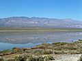
Sometimes flooding causes part of the valley to re-form a lake
-
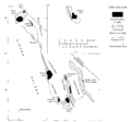
Map of the Owens River system, showing how water flowed through a chain of lakes.
