Argus Range facts for kids
Quick facts for kids Argus Range |
|
|---|---|

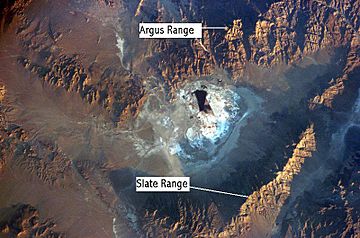
Argus Range, near Searles Dry Lake, Mojave Desert, California
|
|
| Highest point | |
| Peak | Maturango Peak |
| Elevation | 8,843 ft (2,695 m) |
| Geography | |
| Country | United States |
| State | California |
| District | Inyo County |
| Range coordinates | 36°5′8.804″N 117°28′6.223″W / 36.08577889°N 117.46839528°W |
| Topo map | USGS Maturango Peak |
The Argus Range is a group of mountains in Inyo County, California. It's found southeast of the town of Darwin. These mountains form the western edge of Panamint Valley. They also make up the northwestern edge of Searles Valley. To the west of the Argus Range is the Coso Range. To the east is the Panamint Range.
Contents
Exploring the Argus Range
The Argus Range is one of the westernmost mountain ranges in the Basin and Range Province. This is a large area of mountains and valleys in the western United States.
Where is the Argus Range?
The northern part of the range is just south of the Panamint Springs Resort. This resort is located on Highway 190. The mountains stretch south all the way to Argus Peak. This peak is northwest of Searles Lake, near the town of Trona, California. Besides Argus Peak, another important mountain in this range is Maturango Peak.
Tallest Peaks
The highest parts of the Argus Range are inside the NAWS China Lake. This is a military base. Because of this, the tallest peaks in the range are not open to the public.
The two most interesting peaks for hikers are Argus Peak and Maturango Peak. Argus Peak is about 6,562 ft or 2,000 m tall. Maturango Peak is even taller, at about 8,839 ft or 2,694 m. Both of these peaks stand high above the Panamint Valley to the west.
Argus Range Wilderness Area
The Argus Range Wilderness is a special protected area. It is managed by the Bureau of Land Management (BLM). This wilderness area runs for about 28 miles (45 km) along the east side of the Argus Range.
It stretches from the military base on the west side. On the east side, it goes to the foot of the Argus Range mountains. For most of its length, this wilderness area is not very wide. It is usually no more than two miles (3 km) across.
 | Misty Copeland |
 | Raven Wilkinson |
 | Debra Austin |
 | Aesha Ash |


