
Panamint Valley facts for kids

The Panamint Valley is a long valley in eastern California, United States. It's located in the northeastern part of the Mojave Desert. The valley sits between the Argus Range and Slate Range on its west side, and the Panamint Range on its east side.
Where is Panamint Valley?

The northern part of the valley is inside Death Valley National Park in Inyo County, California. The valley runs in a north-south direction. It stretches from the Panamint Dunes in the north down to the Naval Air Weapons Station China Lake in San Bernardino County in the south.
Panamint Valley is about 65 miles (105 kilometers) long. It's also more than 10 miles (16 kilometers) wide in some areas, like near Hall Canyon.
Interesting Places and Features
Panamint Valley has several unique spots:
- Ballarat: This is a ghost town located about three miles east of Trona Road. It's near Happy Canyon.
- Panamint Springs Resort: If you're traveling on Highway 190, this resort is the only place in the area to find lodging, food, and gas. It's located west of Panamint Valley Road, close to Rainbow Canyon.
- Epsom Salts Monorail: An old wooden railway, called the Epsom Salts Monorail, used to cross the valley.
- Radar Station: There is a radar station near the town of Ballarat, at the southern end of the valley.
- Barker Ranch: This historic ranch is located at the southern end of the valley, off Goler Canyon Road.
- Panamint Lake: The valley is a special type of basin called an endorheic basin. This means that water flows into it but doesn't flow out to the ocean. Because of this, the central part of the valley can sometimes have a temporary lake, especially after very heavy rains. For example, a lake appeared here in the spring of 2005 after a lot of rain. During ancient times, when there was much more rain, a huge lake called Lake Panamint filled the valley. This ancient lake even overflowed into another large lake called Lake Manly in Death Valley.
-
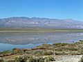
'Panamint Lake' in 2005, view near Ballarat
-
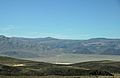
State Route 190 crosses Panamint Valley
-
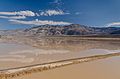
View on Panamint Valley from SR190 with flash floods and reflections in the water


Military Training Area

The sky above Panamint Valley is part of a very large area used by the U.S. military for training. This area is called the R-2508 Special Use Airspace Complex.
The Panamint Military Operating Area (MOA) covers the entire valley. It goes from just 200 feet (61 meters) above the ground up to 18,000 feet (5,486 meters) high. Above that, up to 60,000 feet (18,288 meters), there's another special area for air traffic control.
This airspace is mainly used by military planes from bases like Nellis Air Force Base, Edwards Air Force Base, Naval Air Weapons Station China Lake, and Naval Air Station Lemoore. They use it for training missions at both high and low altitudes. While flying in the Panamint MOA, military aircraft use specific radio frequencies to communicate.

