Panamint Range facts for kids
Quick facts for kids Panamint Range |
|
|---|---|

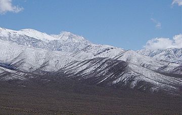
Panamint Range looking toward Telescope Peak
|
|
| Highest point | |
| Elevation | 3,369 m (11,053 ft) |
| Geography | |
| Country | United States |
| State | California |
| District | Inyo County |
| Range coordinates | 36°10′11.816″N 117°5′21.201″W / 36.16994889°N 117.08922250°W |
| Topo map | USGS Telescope Peak |
The Panamint Range is a rugged mountain range in eastern California. It's located in the northern part of the Mojave Desert. This range is a big part of Death Valley National Park in Inyo County.
The name "Panamint" comes from the Paiute or Koso word "Panümünt". This word means "water person". A person named Dr. Darwin French first used the name Panamint in 1860. He was looking for a famous lost silver mine called the Gunsight Lode.
Contents
Geography of the Panamint Range
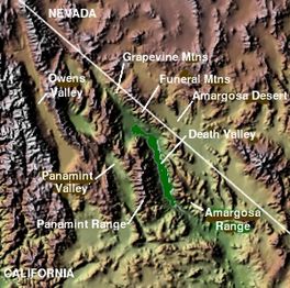
This mountain range stretches about 100 miles (160 km) from north to south. It forms the western edge of Death Valley. On its other side, to the west, is the Panamint Valley.
The Panamint Range is part of a larger area called the Basin and Range Province. This region has many mountains and valleys. The highest point in the Panamint Range is Telescope Peak. It stands tall at 11,049 feet (3,368 meters) above sea level.
Amazing Views and Unique Nature
From some spots in the Panamint Range, you can see two very special places at the same time. You can see Mount Whitney, which is the highest point in the contiguous United States. And you can also see Badwater Basin in Death Valley, which is the lowest point. This makes the Panamint Range one of the few places where you can see both the highest and lowest spots in the country at once!
The Panamint Range is like a "sky island" in the Mojave Desert. This means it gets more rain and has bigger temperature changes than the hot desert floor. Because of this, many unique plants and animals live here. These species are called endemic, meaning they are found only in this special mountain range.
Mining History in the Mountains
The Panamint Mining District is on the western side of the Panamint Range. Many years ago, people came here to mine for valuable minerals.
- Panamint City: This mining town was started in 1873 in the middle of the range.
- Ballarat: This historic mining community began in the 1890s. Today, it is a ghost town, meaning no one lives there anymore.
Another mining area was the Gold Hill Mining District. It started in 1875 in the southwestern part of the range.
Wildrose Charcoal Kilns
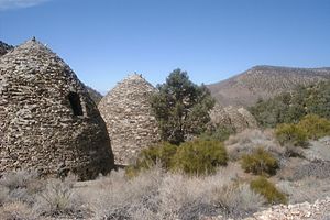
The Wildrose Charcoal Kilns are old buildings located near Wildrose Canyon. They are found in the northern part of the Panamint Range, inside Death Valley National Park. These kilns were finished in 1877.
The Modock Consolidated Mining Company built them to make fuel for their smelters. Smelters are machines that melt down lead and silver from mines in the nearby Argus Range. The kilns are shaped like beehives and are about 25 feet (7.6 meters) tall. There are ten of them, and they are some of the best examples of old charcoal kilns still standing in the western U.S.
 | William L. Dawson |
 | W. E. B. Du Bois |
 | Harry Belafonte |


