
Telescope Peak facts for kids
Quick facts for kids Telescope Peak |
|
|---|---|

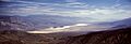
Telescope Peak viewed from Devil's Golf Course, Death Valley, California
|
|
| Highest point | |
| Elevation | 11,043 ft (3,366 m) NAVD 88 |
| Prominence | 6,168 ft (1,880 m) |
| Parent peak | White Mountain Peak |
| Listing |
|
| Geography | |

Telescope Peak
Location in California
|
|
| Location | Death Valley National Park, Inyo County, California, U.S. |
| Parent range | Panamint Range |
| Topo map | USGS Telescope Peak |
| Climbing | |
| Easiest route | Trail from Mahogany Flat (hike) |
Telescope Peak is the highest point in Death Valley National Park in California, U.S.. It is also the tallest mountain in the Panamint Range. The peak is located in Inyo County.
From the top of Telescope Peak, you can see for more than 100 miles in many directions. This includes Mount Whitney to the west and Charleston Peak to the east. The mountain got its name because you can see so far from its summit, like looking through a telescope!
Contents
About Telescope Peak

Telescope Peak stands very tall above the land around it. Its top is about 11,331 feet higher than Badwater Basin. Badwater Basin is the lowest point in Death Valley. This huge height difference happens over just about 15 miles.
The peak also rises about 10,000 feet above the Panamint Valley floor. This makes Telescope Peak one of the mountains with the biggest "vertical rise" in the United States. This means it goes from a very low point to a very high point quickly.
Because it is the highest point in its mountain range, Telescope Peak also has a very high topographic prominence. This means it stands out a lot from other nearby mountains.
Trees on the Mountain
You can find different kinds of trees growing on Telescope Peak. These include the single-leaf pinyon (Pinus monophylla) and limber pine (Pinus flexilis).
At the very highest parts of the mountain, you can even find ancient Great Basin bristlecone pine trees. These trees are known for living for thousands of years!
Hiking Telescope Peak

Hiking to the top of Telescope Peak is a popular adventure. There are a few ways to reach the summit.
Main Hiking Route
The most common way to hike Telescope Peak is a 14-mile round trip. This trail starts at the Mahogany Flat campground in the western part of Death Valley National Park.
The path slowly climbs up to the summit over 7 miles. It has a steady slope, making it a good challenge. The National Park Service takes care of this route. You do not need a special permit to climb the mountain this way.
The trail goes about two miles to Arcane Meadows. From there, it continues for five more miles. It mostly follows the top of the ridge to the summit. This route can also lead to two nearby peaks, Bennett Peak and Rogers Peak.
Advanced Climbing Route
For experienced hikers, there is a much harder route from Shorty's Well. This route starts at about 262 feet below sea level! It climbs all the way up to the 11,049-foot summit.
This journey is about 30 to 34 miles round trip. It involves climbing about 11,311 feet in total. The route begins where West Side Road meets Hanaupah Canyon Road. It climbs into Hanaupah Canyon for 6.5 miles.
About 1.5 miles past the end of the road, you will find Hanaupah Spring. This spring has water sometimes, but not all year. From the spring, the route turns north onto a steep, rocky slope. Hikers must find the best way up this slope. Once you reach the top of the ridge, you follow it west to the summit of Telescope Peak.
Very experienced hikers can finish this route in one day. It is one of the biggest climbs you can do up a single mountain. You can hike back down to Shorty's Well or take the easier Mahogany Flat route.
Images for kids
-
Panamint Valley, California, looking south with Telescope Peak on the left.
-

A 360° view from the summit of Telescope Peak, with Death Valley on the left and Panamint Valley on the right.
