White Mountain Peak facts for kids
Quick facts for kids White Mountain Peak |
|
|---|---|

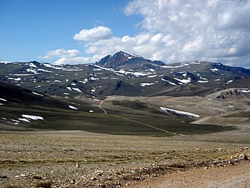
White Mountain Peak from trail, June 2004
|
|
| Highest point | |
| Elevation | 14,252 ft (4344.0 m) NAVD88 |
| Prominence | 7196 ft (2193 m) |
| Isolation | 67.4 mi (108.6 km) |
| Parent peak | Mount Whitney |
| Listing |
|
| Geography | |
| Location | Mono County, California, U.S. |
| Parent range | White Mountains |
| Topo map | USGS White Mountain Peak |
| Geology | |
| Mountain type | Igneous Rock |
| Climbing | |
| Easiest route | Road hike |
White Mountain Peak, also called White Mountain, is a very tall mountain in California. It stands at 14,252 feet (4,344 meters) high. This makes it the highest point in the White Mountains and in Mono County. It is also the third tallest peak in California, after Mount Whitney and Mount Williamson.
White Mountain Peak is one of the most "prominent" peaks in the contiguous United States. This means it rises very high above the land around it. It is also one of only two "fourteeners" (peaks over 14,000 feet) in California that are not part of the Sierra Nevada mountain range. The other one is Mount Shasta.
Contents
Studying the Mountain
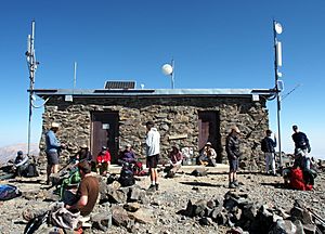
The University of California runs a special research center on White Mountain. It has three stations located at high altitudes. These are Crooked Creek Station at 10,200 feet (3,109 meters) and Barcroft Station at 12,470 feet (3,799 meters). There is also a small hut right at the very top of the mountain.
Scientists at the Barcroft Station and the summit hut study how high altitudes affect the human body. This research helps us understand how people and animals adapt to living in thin air.
Climbing White Mountain Peak
There is a dirt road that goes all the way to the top of White Mountain Peak. This road is usually clear of snow from late June until November. Most of the time, a locked gate stops cars about 2 miles before Barcroft Station. This means people have to hike the rest of the way.
However, the White Mountain Research Station sometimes opens this locked gate once a year. This special "open gate day" usually happens on a Sunday in the summer. On this day, people can drive further up the mountain.
Hiking to the Summit
If you start hiking from the locked gate, the trip to the summit and back is about 14 miles (23 kilometers). You will gain about 2,600 feet (792 meters) in height. The path has two dips, which means you go down a bit before going back up. This adds to the total climbing effort.
On "open gate days," the hike is shorter, saving you about 4 miles (6.4 kilometers) and 790 feet (241 meters) of climbing. Many mountain bikers also enjoy riding this route. Even though the road makes it easier, climbing White Mountain Peak is still a big challenge because of the very high altitude.
Mountain Climate
The top of White Mountain and the weather station at 12,470 feet (3,799 meters) have an alpine tundra climate. This means winters are very harsh and cold. The peak gets a lot of snow every year, sometimes more than 13 feet (4 meters)!
Images for kids
 | George Robert Carruthers |
 | Patricia Bath |
 | Jan Ernst Matzeliger |
 | Alexander Miles |


