Mount Williamson facts for kids
Quick facts for kids Mount Williamson |
|
|---|---|

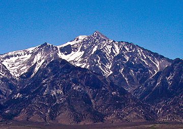
Mount Williamson as seen from Manzanar in the Owens Valley
|
|
| Highest point | |
| Elevation | 14,379 ft (4383 m) NAVD88 |
| Prominence | 1643 ft (501 m) |
| Isolation | 5.44 mi (8.75 km) |
| Parent peak | Mount Whitney |
| Listing |
|
| Geography | |
| Location | Inyo County, California, U.S. |
| Parent range | Sierra Nevada |
| Topo map | USGS Mount Williamson |
| Climbing | |
| First ascent | 1884 by William L. Hunter and C. Mulholland |
| Easiest route | Southeast face from George Creek, easy scramble, class 2 |
Mount Williamson is a very tall mountain in California. It stands at 14,379 feet (4,383 m) high. This makes it the second highest mountain in the Sierra Nevada mountain range. It is also the second highest peak in all of California. In fact, it's the sixth highest peak in the entire contiguous United States!
Contents
Where is Mount Williamson?
Mount Williamson is found in the John Muir Wilderness. This wilderness area is part of the Inyo National Forest. It's located in Inyo County, California.
Its Location and Size
The mountain is about 6 miles (10 km) north of Mount Whitney. Mount Whitney is the highest peak in the contiguous U.S. Mount Williamson is also about 2.5 miles (4 km) southeast of Shepherd Pass. This pass is the closest way to reach the mountain by trail.
The nearest town is Independence, California. It is about 12 miles (19 km) to the north-north-east. Mount Williamson sits about 1 mile (1.6 km) east of the Sierra Crest. This crest forms the western edge of the Owens Valley.
Even though it's close to the valley, Mount Williamson is a very imposing mountain. It drops about 8,000 feet (2,400 m) in just 4 miles (6.4 km) to the forest below. Because it's so big and hard to reach, it's not as popular for climbing as Mount Whitney.
The Mountain's Story
Mount Williamson has an interesting history, including how it got its name.
Who Was It Named After?
The mountain is named after Lieutenant Robert S. Williamson. He lived from 1825 to 1882. Lt. Williamson was a surveyor who worked on the Pacific Railroad Surveys. These surveys helped map out routes for railroads in Southern California.
First Climbers
The first time someone officially climbed Mount Williamson was in 1884. Two climbers, W. L. Hunter and C. Mulholland, made this first ascent. They used a path called the Southeast Slopes Route.
Later, in 1896, Bolton C. Brown and Lucy Brown were the first to climb the West Side Route. Over the years, many new climbing paths have been found on the mountain's tougher sides.
Climbing Mount Williamson
Climbing Mount Williamson is a big challenge. It requires a lot of effort and preparation.
Popular Routes
The most common way to climb Mount Williamson is called the West Side Route. You can get to this route from Shepherd's Pass. From the pass, climbers cross an area called the Williamson Bowl. This bowl is between Mount Williamson and Mount Tyndall. It has five beautiful high alpine lakes.
From the bowl, the route goes up steep gullies on the west side of the mountain. This part involves some scrambling. Another route is the Southeast Slopes Route. It starts from George Creek. This route is technically easier, but it's harder to get to. You might need to find your own way and push through bushes. There are also more difficult climbing routes, like the North Rib.
A Challenging Climb
Climbing Mount Williamson is tough because of the long and tiring journey to get there. The trail to Shepherd's Pass alone is 11 miles (18 km) long. From the start of the trail, climbers gain over 8,000 feet (2,400 m) in height to reach the summit.
Home to Bighorn Sheep
Mount Williamson is part of the California Bighorn Sheep Zoological Area. These rare animals can often be seen on the lower parts of the mountain. This usually happens in winter when heavy snow forces them down from their summer feeding grounds.
For many years, parts of this area were closed to people for much of the year. This was to protect the sheep. But in 2010, the Inyo National Forest Service decided to open the area year-round.
 | May Edward Chinn |
 | Rebecca Cole |
 | Alexa Canady |
 | Dorothy Lavinia Brown |


