
Mount Tyndall facts for kids
Quick facts for kids Mount Tyndall |
|
|---|---|
 |
|
| Highest point | |
| Elevation | 14,025 ft (4,275 m) NAVD 88 |
| Prominence | 1,092 ft (333 m) |
| Parent peak | Mount Williamson |
| Listing |
|
| Geography | |

Mount Tyndall
Location in California

Mount Tyndall
Location in the United States
|
|
| Location | Inyo / Tulare counties, California, U.S. |
| Parent range | Sierra Nevada |
| Topo map | USGS Mount Williamson |
| Climbing | |
| First ascent | July 6, 1864 by Clarence King and Richard Cotter |
| Easiest route | Scramble, class 2 |
Mount Tyndall is a tall mountain peak located in the Sierra Nevada mountain range in California, U.S.. It stands at a height of 14,025 feet (4,275 meters). This makes it the tenth highest mountain in California.
The mountain was named after John Tyndall, an Irish scientist and mountaineer.
Contents
Where is Mount Tyndall Located?
Mount Tyndall sits on the Sierra Crest. This is a high ridge that forms a natural border. It separates the John Muir Wilderness and Inyo National Forest on its east side. On its west side, it borders Sequoia National Park.
The mountain also marks the boundary between Inyo and Tulare counties. It is about 1.5 miles (2.4 km) west of Mount Williamson. It is also about 6 miles (9.7 km) north-northeast of the famous Mount Whitney.
The First Climb of Mount Tyndall
Mount Tyndall was first climbed on July 6, 1864. The climbers were Clarence King and Richard D. Cotter. They were part of the California Geological Survey. This group explored and mapped California's land.
King and Cotter had a big goal: to be the first to climb Mount Whitney. They traveled a long way from Kings Canyon National Park. After their climb, they thought they had reached Mount Whitney. However, they later found out they had actually climbed Mount Tyndall by mistake!
Climbing Routes on Mount Tyndall
The easiest way to climb Mount Tyndall is by using the Northwest Ridge. This route involves an easy "scramble." Scrambling means climbing over rocks and steep ground using both your hands and feet. This route is rated as class 2 on the Yosemite Decimal System, which means it's a basic scramble.
The Northwest Ridge starts about half a mile (0.8 km) west of Shepherd Pass. It is also about 1 mile (1.6 km) north of the mountain's peak. Other simple routes are found on the gentler western side of the mountain.
The eastern side of Mount Tyndall is much steeper. It has at least two challenging technical climbing routes. The first of these difficult routes was climbed in 1970. It was completed by famous mountaineer Fred Beckey and Charlie Raymond.
Images for kids
-
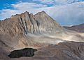
Mount Tyndall, seen from its east side.

