Sierra Crest facts for kids
Quick facts for kids Sierra Crest |
|
|---|---|

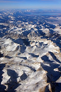
View of Sierra Crest near Mount Abbot and Mount Mills
|
|
| Highest point | |
| Peak | Mount Whitney |
| Elevation | 14,505 ft (4,421 m) NAVD88 |
| Dimensions | |
| Length | 500 mi (800 km) |
| Geography | |
| Location | California, United States |
The Sierra Crest is like the backbone of the Sierra Nevada mountains in California, United States. It's a long, high ridge that runs for about 500 miles (800 km) from north to south. This crest acts like a natural divider, separating the wide western slopes of the Sierra Nevada from its narrower eastern side.
What is the Sierra Crest?
The Sierra Crest is a long, high line of mountains. It marks the highest points of the Sierra Nevada mountain range. Think of it as the very top edge of a giant roof. This crest helps to separate the land that slopes down to the west from the land that slopes down to the east.
Where is the Sierra Crest Located?
The Sierra Crest stretches across a huge part of California. It starts in the north and goes all the way south. For much of its length, it forms part of the Great Basin Divide. This means that rain and snow falling on one side of the crest flow towards the Pacific Ocean, while on the other side, they flow into the Great Basin, which has no outlet to the sea.
The southern part of the crest also separates different counties in California, like Tulare and Inyo counties. It even extends into Kern County and connects with the Tehachapi Mountains.
Sometimes, the Sierra Crest splits into two paths around special bowl-shaped valleys called cirques. These cirques are often filled with lakes that don't drain into other rivers.
Exploring the Crest: The John Muir Trail
Many years ago, a person named Theodore Solomons tried to map a route along the Sierra Crest. He was very important in imagining and exploring the path that later became the famous John Muir Trail.
The John Muir Trail is a long hiking path that follows the crest of the Sierra Nevada. It starts in Yosemite Valley and goes all the way to Mount Whitney. Mount Whitney is the highest point in the Sierra Nevada and the highest mountain in the lower 48 United States. This trail lets hikers experience the amazing views and wild beauty of the Sierra Crest.
 | William Lucy |
 | Charles Hayes |
 | Cleveland Robinson |

