
Kern County, California facts for kids
Quick facts for kids
Kern County
|
||
|---|---|---|
     Images, from top down, left to right: Downtown Bakersfield, Cesar E. Chavez National Monument, Fort Tejon barracks, an F-35 landing at Edwards Air Force Base, the Midway-Sunset Oil Field
|
||
|
||

Location in the state of California
|
||
| Country | United States | |
| State | California | |
| Incorporated | April 2, 1866 | |
| Named for | Kern River and Edward Kern | |
| County seat | Bakersfield | |
| Largest city | Bakersfield (population) California City (area) |
|
| Incorporated cities | 11 | |
| Government | ||
| • Type | Council–Administration | |
| • Body | Board of Supervisors | |
| Area | ||
| • Total | 8,163 sq mi (21,140 km2) | |
| • Land | 8,132 sq mi (21,060 km2) | |
| • Water | 31 sq mi (80 km2) | |
| Highest elevation | 8,755 ft (2,669 m) | |
| Lowest elevation | 206 ft (63 m) | |
| Population | ||
| • Total | 909,235 | |
| • Estimate
(2023)
|
913,820 |
|
| • Density | 111.385/sq mi (43.0060/km2) | |
| GDP | ||
| • Total | $57.541 billion (2022) | |
| Time zone | UTC−8 (Pacific Time Zone) | |
| • Summer (DST) | UTC−7 (Pacific Daylight Time) | |
| Area code | 661, 760 | |
| FIPS code | 06-029 | |
| GNIS feature ID | 2054176 | |
| Congressional districts | 20th, 22nd, 23rd | |

Kern County is a large county in the state of California, USA. As of 2020, about 909,235 people live there. Its main city and government center is Bakersfield.
Kern County is part of the Bakersfield metropolitan area. It covers the southern part of California's Central Valley. The county is huge, about 8,161 square miles. It stretches from the Coast Ranges in the west to the Sierra Nevada mountains and into the Mojave Desert in the east.
The county's economy mostly relies on farming and getting oil from the ground. It also has a big presence in aviation, space, and the military. Important places like Edwards Air Force Base and the China Lake Naval Air Weapons Station are located here.
More than half of the people in Kern County are of Hispanic or Latino background. This makes it one of the largest counties in California with a majority Hispanic population.
History of Kern County
Early People and Spanish Explorers
Long ago, Native American groups like the Chumash and Yokuts lived in this area for hundreds of years. In 1769, Spain claimed the land. The first European to visit was Commander Don Pedro Fages in 1772.
A small battle called the Battle of San Emigdio happened in 1824. It was between the Chumash Native Americans and the Mexican government. The Chumash were upset because their mission lands were being taken. The battle was not very bloody, and the Chumash later returned to Santa Barbara.
How Kern County Became Part of the USA

When the United States took over, mining became very important in the mountains and desert parts of the area. In 1866, Kern County was officially formed. It was made from parts of Tulare, Los Angeles, and San Bernardino Counties. The first county seat (government center) was a mining town called Havilah.
At first, people thought the valley floor was too swampy for farming. But settlers started draining the land and building canals, often with the help of Chinese workers. Within ten years, farming in the valley became more important than mining. Because of this, the county seat moved from Havilah to Bakersfield in 1874.
In 1899, oil was discovered in the Kern River Oil Field. This led to the creation of towns like Oil City, Oil Center, and Oildale.
Where Did the Name "Kern" Come From?
Kern County gets its name from the Kern River. The river was named after Edward Kern. He was a mapmaker who explored the area in 1845 with General John C. Frémont.
Earthquakes in Kern County
Kern County has experienced strong earthquakes. One famous one was the 1857 Fort Tejon earthquake.
On July 21, 1952, a big earthquake happened about 23 miles south of Bakersfield. It was very strong, measuring 7.3 on the moment magnitude scale. Twelve people died, and hundreds were hurt. There was also over $60 million in damage. The earthquake was felt across much of California. Tehachapi was hit the hardest.
After the main earthquake, many smaller quakes (aftershocks) continued for weeks. The strongest aftershock happened on August 22, causing more damage and two more deaths. These earthquakes helped scientists learn a lot about how the ground moves during quakes.
Geography of Kern County
.png)
Kern County is the third-largest county in California by area. It covers about 8,163 square miles. That's almost as big as the entire state of New Hampshire! The highest point in the county is Sawmill Mountain, which is 8,822 feet tall.
The county stretches in different directions:
- To the east, it goes past the Sierra Nevada mountains and into the Mojave Desert. This includes parts of the Indian Wells Valley and Antelope Valley.
- To the west, it crosses the San Joaquin Valley floor to the Temblor Range, which is part of the Coast Ranges.
- To the south, it goes over the Tehachapi Mountains.
Air Quality in Kern County

Kern County often has problems with air pollution. Small particles in the air can make it hard to see, especially in winter. The western part of the county is in the San Joaquin Valley, where mountains can trap pollutants. This means the air can be unhealthy for many days each year.
Plants and Nature
A type of plant community called Chaparral covers a lot of Kern County. While there are many chaparral plants, the variety of species here is less than in other parts of California. You can find plants like Whitethorn on rocky slopes. The California Buckeye tree also grows here, marking its southernmost range.
Protected Natural Areas
Kern County is home to several important protected areas:
- Bitter Creek National Wildlife Refuge
- Carrizo Plain National Monument (part)
- César E. Chávez National Monument
- Giant Sequoia National Monument (part)
- Kern National Wildlife Refuge
- Los Padres National Forest (part)
- Sequoia National Forest (part)
People of Kern County
| Historical population | |||
|---|---|---|---|
| Census | Pop. | %± | |
| 1870 | 2,925 | — | |
| 1880 | 5,601 | 91.5% | |
| 1890 | 9,808 | 75.1% | |
| 1900 | 16,480 | 68.0% | |
| 1910 | 37,715 | 128.9% | |
| 1920 | 54,843 | 45.4% | |
| 1930 | 82,570 | 50.6% | |
| 1940 | 135,124 | 63.6% | |
| 1950 | 228,309 | 69.0% | |
| 1960 | 291,984 | 27.9% | |
| 1970 | 329,162 | 12.7% | |
| 1980 | 403,089 | 22.5% | |
| 1990 | 543,477 | 34.8% | |
| 2000 | 661,645 | 21.7% | |
| 2010 | 839,631 | 26.9% | |
| 2020 | 909,235 | 8.3% | |
| 2023 (est.) | 913,820 | 8.8% | |
| U.S. Decennial Census 1790–1960 1900–1990 1990–2000 2010 2020 |
|||
In 2020, Kern County had a population of 909,235 people. It is the eleventh-largest county in California by population. The exact middle point of California's population is located in Kern County, near the town of Buttonwillow.
Who Lives in Kern County?
The people of Kern County come from many different backgrounds. Here's a look at the population based on the 2020 census:
- Hispanic or Latino: 54.9%
- White (not Hispanic): 30.8%
- Black: 5.5%
- Asian: 5.1%
- Two or more races: 3.14%
- Native American: 0.57%
- Other races: 0.50%
(Note: The total can be over 100% because Hispanic/Latino is an ethnic group, and people of any race can be Hispanic/Latino).
In 2000, the average household had about 3 people, and the average family had about 3.5 people. The median income for a household was $35,446. About 20.8% of the population lived below the poverty line.
Arts and Culture
Kern County is known for the Bakersfield sound, a special type of country music. The Buck Owens Crystal Palace, a famous music venue, is in Bakersfield.
Economy of Kern County
Kern County has a strong economy based on farming and energy. It produces a lot of oil, natural gas, and hydro-electric power. It's also a big producer of Biomass, solar power, and wind power.
The county is rich in minerals like gold, borate, and kernite. The largest open pit mine in California, which digs for borax, is located in Boron. Kern County creates almost 25% of California's renewable energy! This includes a lot of solar and wind power.
Aerospace and Military
Kern County is very important for aerospace and the military. It's home to Edwards Air Force Base, which is the Air Force's main flight test center. Many important aviation events happened here, like the first supersonic flight and the first landing of the Space Shuttle.
The China Lake Naval Air Weapons Station is also in Kern County. These bases have helped towns like Mojave and Rosamond grow. Kern County also has the first inland spaceport in the U.S., the Mojave Spaceport.
Farming in Kern County
Farming has always been one of the biggest industries in Kern County. Between 2012 and 2013, the value of farm products grew to $6.8 billion.
Here are some of the main crops and products:
- Grapes: 31%
- Almonds: 17%
- Milk: 13%
- Citrus fruits: 11%
- Cattle and calves: 7%
- Pistachios: 7%
- Carrots: 6% (Kern County grows 80% of all carrots in the U.S.!)
- Hay: 4%
- Cotton and potatoes: 2% each
Kern County is one of the highest-producing areas in the United States for vegetables and watermelons. There are about 1,938 farms in the county.
Kern County is a major producer of almonds, making over 100 million pounds each year. This is about 16% of California's total almond production. Pistachios are also a big crop here.
Oil Production Today
Kern County is California's top oil-producing county. In 2015, it had 78% of the state's active oil wells and produced 71% of California's oil. The county produced 144.5 million barrels of oil in 2015, which is about 4% of all oil produced in the U.S.
Oil was discovered here very early, even before the county was officially formed. The Buena Vista Petroleum Company started in 1864. The discovery of the Midway-Sunset Oil Field in 1894 was a huge step. It is now the third-largest oil field in the United States.
A famous event was the Lakeview Gusher in 1910. This was the biggest oil strike ever recorded in U.S. history! The well shot out about nine million barrels of oil for 18 months before workers could finally stop it.
Other big oil fields in Kern County include the Kern River Oil Field (the fifth-largest in the U.S.), the Kern Front Oil Field, and the Fruitvale Oil Field, which is under much of Bakersfield.
In 2009, Occidental Petroleum found a huge new oil and natural gas reserve in Kern County. This was the biggest oil discovery in California in 35 years!
Some of the large oil fields still active in Kern County today are:
- Buena Vista Oil Field
- Cymric Oil Field
- Edison Oil Field
- Elk Hills Oil Field
- Fruitvale Oil Field
- Kern Front Oil Field
- Kern River Oil Field
- Lost Hills Oil Field
- McKittrick Oil Field
- Midway-Sunset Oil Field
- Mountain View Oil Field
- Mount Poso Oil Field
- North Belridge Oil Field
- Round Mountain Oil Field
- South Belridge Oil Field
Getting Around Kern County
Major Roads
Many important highways run through Kern County, connecting different parts of California. These include:
 Interstate 5
 U.S. Route 395
 State Route 14
 State Route 33
 State Route 41
 State Route 43
 State Route 46
 State Route 58
 State Route 65
 State Route 99
 State Route 119
 State Route 155
 State Route 166
 State Route 178
 State Route 184
 State Route 202
 State Route 204
 State Route 223
Public Transportation
Kern County has several public transportation options:
- Arvin Transit and Delano Area Rapid Transit offer local bus services in their cities.
- Golden Empire Transit provides bus service in and around Bakersfield.
- Kern Transit connects towns across the county.
- You can also travel by Greyhound and Orange Belt Stages buses, and Amtrak trains from the Bakersfield station.
Airports in Kern County
Meadows Field in Bakersfield is the only airport with regular passenger flights. Other airports in the county are used for general aviation:
- California City Municipal Airport
- Delano Municipal Airport
- Inyokern Airport
- Kern Valley Airport
- Lost Hills Airport
- Mojave Airport
- Shafter Airport (Minter Field)
- Taft Airport
- Tehachapi Municipal Airport
- Wasco Airport
Fun Things to Do
Kern County offers many outdoor activities:
- You can go horseback riding.
- Enjoy water skiing at places like Lake Isabella, Lake Buena Vista, and Lake Ming.
- For motorsports, there's off-roading at Jawbone Canyon, California City, and Randsburg.
- You can also visit tracks like Willow Springs, Buttonwillow, Bakersfield Speedway, Famoso Raceway, and Kern County Raceway Park.
- Other activities include hunting, paintball, white-water rafting and kayaking on the Kern River.
- In winter, you can go snow skiing at Shirley Meadows and Mount Pinos.
- There are also shooting ranges, hiking and biking trails, camping, and fishing.
Media in Kern County
Magazines
- Bakersfield Life Magazine
- Bakersfield Magazine
- Kern County Family Magazine
Newspapers
- The Bakersfield Californian (for all of Kern County)
- Mountain Enterprise (for the southwest mountains)
- Mojave Desert News (for California City and the eastern desert)
- The Daily Independent (for Ridgecrest and Indian Wells Valley)
- The Kern Valley Sun (for the Kern Valley area)
- Kern River Courier (for the Kern Valley area)
- Tehachapi News (for Tehachapi)
- Taft Midway Driller (for Taft)
- Taft Independent (for Taft)
- The Delano Record (for Delano)
TV Stations
Kern County is served by TV stations based in Bakersfield:
People in eastern Kern County, like in California City and Ridgecrest, might also watch TV stations from Los Angeles.
Communities in Kern County
Cities
- Arvin
- Bakersfield (the county seat)
- California City
- Delano
- Maricopa
- McFarland
- Ridgecrest
- Shafter
- Taft
- Tehachapi
- Wasco
Census-Designated Places (CDPs)
These are areas that are like towns but are not officially incorporated as cities.
- Alta Sierra
- Bakersfield Country Club
- Bear Valley Springs
- Bodfish
- Boron
- Buttonwillow
- Casa Loma
- Cherokee Strip
- China Lake Acres
- Derby Acres
- Di Giorgio
- Dustin Acres
- East Bakersfield
- Edison
- Edmundson Acres
- Edwards AFB
- El Adobe
- Fellows
- Ford City
- Frazier Park
- Fuller Acres
- Glennville
- Golden Hills
- Greenacres
- Greenfield
- Inyokern
- Johannesburg
- Keene
- Kernville
- Lake Isabella
- Lake of the Woods
- Lamont
- Lebec
- Lost Hills
- McKittrick
- Mettler
- Mexican Colony
- Mojave
- Mountain Mesa
- Mountain Meadows
- North Edwards
- Oildale
- Olde Stockdale
- Old River
- Onyx
- Pine Mountain Club
- Pumpkin Center
- Randsburg
- Rosamond
- Rosedale
- Smith Corner
- South Taft
- Squirrel Mountain Valley
- Stallion Springs
- Stebbins
- Tarina
- Taft Heights
- Tupman
- Valley Acres
- Weedpatch
- Weldon
- Wofford Heights
- Woody
Other Unincorporated Communities
These are smaller communities that are not cities or CDPs.
- Actis
- Aerial Acres
- Bealville
- Bena
- Caliente
- Canebrake
- Cantil
- Cawelo
- Claraville
- Edwards
- Famoso
- Grapevine
- Gypsite
- Havilah
- Indian Wells
- Keyesville
- Loraine
- Midoil
- Miracle Hot Springs
- Missouri Triangle
- Monolith
- Old Garlock
- Old West Ranch
- Panama
- Pentland
- Pond
- Reward
- Rio Bravo
- Riverkern
- Sageland
- Saltdale
- Sand Canyon
- South Lake
- Spicer City
- Twin Oaks
- Wheeler Ridge
- Willow Springs
- Wonder Acres
Education in Kern County
Kern County has many school districts, which are groups of schools managed together. They are divided into different types:
Unified School Districts
These districts manage schools from elementary to high school.
- El Tejon Unified School District
- Maricopa Unified School District
- McFarland Unified School District
- Mojave Unified School District
- Muroc Joint Unified School District
- Sierra Sands Unified School District
- Southern Kern Unified School District
- Tehachapi Unified School District
High School Districts
These districts focus only on high schools.
- Delano Joint Union High School District
- Kern High School District
- Taft Union High School District
- Wasco Union High School District
Elementary School Districts
These districts manage elementary schools.
- Arvin Union School District
- Bakersfield City School District
- Beardsley Elementary School District
- Belridge Elementary School District
- Blake Elementary School District
- Buttonwillow Union Elementary School District
- Caliente Union Elementary School District
- Delano Union Elementary School District
- Di Giorgio Elementary School District
- Edison Elementary School District
- Elk Hills Elementary School District
- Fairfax Elementary School District
- Fruitvale Elementary School District
- General Shafter Elementary School District
- Greenfield Union School District
- Kernville Union Elementary School District
- Lakeside Union School District
- Lamont Elementary School District
- Linns Valley-Poso Flat Union School District
- Lost Hills Union Elementary School District
- Maple Elementary School District
- McKittrick Elementary School District
- Midway Elementary School District
- Norris Elementary School District
- Panama-Buena Vista School District
- Pond Union Elementary School District
- Richland Union School District
- Rio Bravo-Greeley Union Elementary School District
- Rosedale Union Elementary School District
- Semitropic Elementary School District
- South Fork Union School District
- Standard Elementary School District
- Taft City School District
- Vineland Elementary School District
- Wasco Union Elementary School District
Images for kids
-
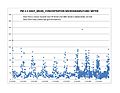
Particulate pollution in Kern County varies with the seasons.
-
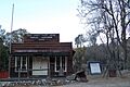
The Havilah Court building was restored in the 1970s and now serves as a museum. Photo circa 2007.
-
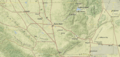
Map of Kern County
See also
 In Spanish: Condado de Kern para niños
