Tehachapi, California facts for kids
Quick facts for kids
Tehachapi, California
|
||
|---|---|---|
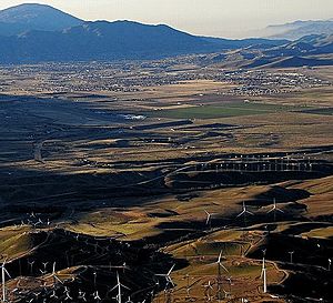
View of wind turbines with Tehachapi in the distance
|
||
|
||
| Nickname(s):
The Land of Four Seasons
|
||
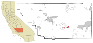
Location of Tehachapi, California
|
||
| Country | ||
| State | ||
| County | Kern | |
| Region | Tehachapi Mountains | |
| Founded | 1876 | |
| Incorporated | August 13, 1909 | |
| Named for | Kawaiisu for "hard climb" | |
| Government | ||
| • Type | Council-manager | |
| Area | ||
| • City | 10.35 sq mi (26.81 km2) | |
| • Land | 10.26 sq mi (26.56 km2) | |
| • Water | 0.10 sq mi (0.25 km2) 0.93% | |
| Elevation | 3,970 ft (1,210 m) | |
| Population
(2020)
|
||
| • City | 12,939 | |
| • Estimate
(2024)
|
11,114 | |
| • Density | 1,261.6/sq mi (487.1/km2) | |
| • Urban | 17,298 | |
| Time zone | UTC−8 (Pacific) | |
| • Summer (DST) | UTC−7 (PDT) | |
| ZIP Code |
93561
|
|
| Area code | 661 | |
| FIPS code | 06-78092 | |
| GNIS feature IDs | 1652798, 2412041 | |
| Reference #: | 643 | |
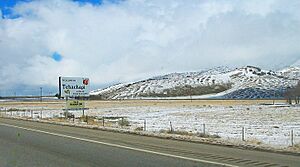
Tehachapi (in the Kawaiisu language: Tihachipia, meaning "hard climb") is a city in Kern County, California, United States. It is located in the Tehachapi Mountains, about 3,970 feet (1,210 meters) above sea level. The city sits between the San Joaquin Valley and the Mojave Desert. Tehachapi is about 35 miles (56 km) east-southeast of Bakersfield and 20 miles (32 km) west of Mojave.
The city covers a total area of about 10 square miles (26 km2) and had a population of 12,939 people in 2020. The Tehachapi area is famous for the nearby Tehachapi Loop, which is a popular spot for train enthusiasts. It is also known for the Pacific Crest Trail and for being a great place for the aerial sport of gliding.
Contents
History of Tehachapi
The Kawaiisu people are a Native American tribe whose home was the Tehachapi Valley for thousands of years. They also lived seasonally in the southern Sierra Nevada and the Mojave Desert.
The name Tehachapi likely comes from the Kawaiisu language. It might be from the word tihachipia, which means "hard climb." This is according to the Tomi-Kahni Resource Center. The area has been known by other names and spellings in the past, like Tehachapai and Summit Station.
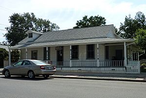
The first settlement in the Tehachapi Valley was called Williamsburg or 'Tehichipa'. It was founded in the 1860s. This place, now known as ‘Old Town’, was about four miles west of today's downtown Tehachapi. It was an important stop on the road that connected the San Joaquin Valley with Southern California. It is now recognized as California Historical Landmark #643 because it is the oldest settlement in the Tehachapi Valley.
In 1869, Peter D. Greene, a gold prospector and rancher, became the postmaster for a new post office called ‘Tehichipa’. This was the only post office in the area. Later, in 1875, Greene started the community of Greenwich, which was three miles east of Williamsburg.
The Southern Pacific Railroad line through the Tehachapi Pass was finished in July 1876. This railroad was a very important link, connecting San Francisco and Los Angeles. A telegraph office near the railroad tracks became the first building in what would become downtown Tehachapi. This is where the Tehachapi Railroad Depot was built.
The depot is now listed on the National Register of Historic Places. It was the oldest building in downtown Tehachapi until it burned down in June 2008. The building was being turned into a museum at the time. It has since been rebuilt using the original plans and opened again on June 5, 2010.
The new railroad town was named Tehachapi Summit. Williamsburg and Greenwich became less important because the railroad bypassed them. Many people moved to the new town. In 1885, the post office moved to Tehachapi Summit, and its name was changed to ‘Tehachapi’ in 1893. The town officially became a city on August 13, 1909.
The 1952 Kern County Earthquake
In 1952, Tehachapi experienced a strong earthquake. It had a magnitude of 7.3 on the Richter Scale. This earthquake caused significant damage to buildings and train tracks in the area. It was the largest earthquake in Southern California in the 20th century at that time.
Geography and Climate
Geographic Features
Downtown Tehachapi is about 15 miles (24 km) from the White Wolf Fault. It is also about 6 miles (10 km) from the Garlock Fault and 30 miles (48 km) from the San Andreas Fault. These are major fault lines in California.
Tehachapi's Climate
Tehachapi has a hot-summer mediterranean climate. This means it has warm, dry summers and mild, wet winters.
Tehachapi is famous for having four distinct seasons. The wet season usually runs from November to May. However, thunderstorms can happen during the summer, especially near the mountain peaks. Average temperatures in July range from 58°F to 88°F (14°C to 31°C). In January, they range from 29°F to 52°F (-2°C to 11°C). The area typically gets about 15 to 20 inches (38 to 51 cm) of snow each winter.
On average, there are about 31 days each year when temperatures reach 91°F (33°C) or higher. There are also about 95 days when temperatures drop to 31°F (-0.5°C) or lower.
Because Tehachapi is close to the Tehachapi Pass, it is often very windy. Air from the San Joaquin Valley is pushed up through a narrow canyon into the mountains, causing strong winds. These winds usually come from the northwest. In winter, strong winds can make it feel much colder than the actual temperature.
The highest temperature ever recorded was 105°F (41°C) on July 27, 1934. The lowest temperature ever recorded was -4°F (-20°C) on January 14, 1932, and December 21, 1967. The city receives about 11.08 inches (281 mm) of rain each year. It usually rains on about 42 days annually.
| Climate data for Tehachapi, California (Elevation 3,970ft) | |||||||||||||
|---|---|---|---|---|---|---|---|---|---|---|---|---|---|
| Month | Jan | Feb | Mar | Apr | May | Jun | Jul | Aug | Sep | Oct | Nov | Dec | Year |
| Record high °F (°C) | 75 (24) |
78 (26) |
81 (27) |
89 (32) |
97 (36) |
104 (40) |
105 (41) |
104 (40) |
102 (39) |
96 (36) |
85 (29) |
81 (27) |
105 (41) |
| Mean maximum °F (°C) | 65 (18) |
66 (19) |
72 (22) |
78 (26) |
86 (30) |
93 (34) |
97 (36) |
95 (35) |
92 (33) |
96 (36) |
73 (23) |
66 (19) |
98 (37) |
| Mean daily maximum °F (°C) | 51.3 (10.7) |
54.0 (12.2) |
56.0 (13.3) |
62.6 (17.0) |
70.6 (21.4) |
79.7 (26.5) |
87.1 (30.6) |
86.3 (30.2) |
80.4 (26.9) |
70.8 (21.6) |
59.6 (15.3) |
52.3 (11.3) |
67.6 (19.8) |
| Daily mean °F (°C) | 40.4 (4.7) |
42.8 (6.0) |
44.7 (7.1) |
50.0 (10.0) |
56.7 (13.7) |
65.6 (18.7) |
72.1 (22.3) |
70.6 (21.4) |
64.2 (17.9) |
55.7 (13.2) |
47 (8) |
41.3 (5.2) |
54.3 (12.4) |
| Mean daily minimum °F (°C) | 29.6 (−1.3) |
31.6 (−0.2) |
33.5 (0.8) |
37.5 (3.1) |
43.8 (6.6) |
51.5 (10.8) |
57.2 (14.0) |
54.9 (12.7) |
48.1 (8.9) |
40.7 (4.8) |
34.4 (1.3) |
30.4 (−0.9) |
41.1 (5.1) |
| Mean minimum °F (°C) | 18 (−8) |
19 (−7) |
23 (−5) |
27 (−3) |
33 (1) |
40 (4) |
49 (9) |
48 (9) |
40 (4) |
31 (−1) |
23 (−5) |
17 (−8) |
14 (−10) |
| Record low °F (°C) | −4 (−20) |
4 (−16) |
9 (−13) |
17 (−8) |
26 (−3) |
29 (−2) |
36 (2) |
32 (0) |
22 (−6) |
17 (−8) |
6 (−14) |
−4 (−20) |
−4 (−20) |
| Average precipitation inches (mm) | 1.85 (47) |
1.82 (46) |
1.94 (49) |
0.92 (23) |
0.43 (11) |
0.11 (2.8) |
0.11 (2.8) |
0.25 (6.4) |
0.32 (8.1) |
0.48 (12) |
1.13 (29) |
1.70 (43) |
11.08 (281) |
| Average snowfall inches (cm) | 5.7 (14) |
3.0 (7.6) |
6.4 (16) |
2.0 (5.1) |
0.3 (0.76) |
0 (0) |
0 (0) |
0 (0) |
0 (0) |
0 (0) |
1.6 (4.1) |
4.3 (11) |
23.3 (59) |
| Source: The Western Regional Climate Center | |||||||||||||
Tehachapi's Population
The population of Tehachapi was 14,414 people in 2010. This was an increase from 10,957 people in 2000.
| Historical population | |||
|---|---|---|---|
| Census | Pop. | %± | |
| 1890 | 255 | — | |
| 1910 | 385 | — | |
| 1920 | 458 | 19.0% | |
| 1930 | 736 | 60.7% | |
| 1940 | 1,264 | 71.7% | |
| 1950 | 1,685 | 33.3% | |
| 1960 | 3,161 | 87.6% | |
| 1970 | 4,211 | 33.2% | |
| 1980 | 4,126 | −2.0% | |
| 1990 | 5,791 | 40.4% | |
| 2000 | 10,957 | 89.2% | |
| 2010 | 14,414 | 31.6% | |
| 2020 | 12,939 | −10.2% | |
| 2024 (est.) | 11,114 | −22.9% | |
| U.S. Decennial Census | |||
Population in 2020
The 2020 United States census reported that Tehachapi had a population of 12,939 people. The population density was about 1,261.6 people per square mile (487.1 per km2).
The city is home to people from many different backgrounds. In 2020, the population included 53.3% White people, 8.1% African American people, 1.3% Native American people, 2.3% Asian people, and 0.2% Pacific Islander people. About 23.2% were from other races, and 11.7% were from two or more races. People who identify as Hispanic or Latino made up 36.6% of the population.
The census showed that 71.9% of the population lived in regular households. The remaining 28.1% lived in places like group homes or institutions.
There were 3,526 households in Tehachapi. About 36.8% of these households included children under 18. The average household size was 2.64 people. There were 2,343 families in total.
The age groups in Tehachapi were spread out. About 19.2% of the population was under 18 years old. About 12.1% were 65 years of age or older. The median age was 37.6 years.
There were 3,784 housing units in the city. Most of these, 93.2%, were occupied. About 56.6% of the homes were owned by the people living in them, and 43.4% were rented.
In 2023, the average household income was $67,785. The average income per person was $23,388.
Population in 2010
The 2010 United States Census reported that Tehachapi had a population of 14,414 people. The population density was about 1,445.7 people per square mile (558.2 per km2).
The racial makeup of Tehachapi in 2010 included 65.4% White people, 9.0% African American people, 1.4% Native American people, 1.7% Asian people, and 0.1% Pacific Islander people. About 18.9% were from other races, and 3.5% were from two or more races. People who identified as Hispanic or Latino made up 37.9% of the population.
The Census reported that 58.9% of the population lived in households. About 41.1% lived in institutional settings.
There were 3,121 households. About 38.4% of these had children under the age of 18 living in them. The average household size was 2.72 people. There were 2,103 families in total.
The population was spread out by age. About 18.0% were under 18 years old. About 8.8% were 65 years of age or older. The median age was 34.4 years.
There were 3,539 housing units. About 59.0% were owned by residents, and 41.0% were rented.
Tehachapi's Economy
Historically, Tehachapi's economy was based on farming. People grew apples, peaches, grains, vegetables, and hay all year round.
Wine grapes were grown in the area for a long time, until a period called Prohibition. More recently, the Tehachapi Mountains American Viticultural Area was approved in 2020. This area is about 58,000 acres (23,000 hectares) and is used for growing grapes for wine.
About half of Tehachapi's water comes from groundwater, which is refilled by local rain. The other half comes from the California Aqueduct, a large system that brings water from far away.
A large correctional facility, also known as Tehachapi State Prison, is located in the area. Edwards Air Force Base is about 40 miles (64 km) to the east.
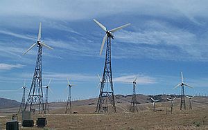
The Tehachapi area is a major center for renewable energy from wind. As of 2019, there were 4,531 wind turbines that could produce 3,200 megawatts of electricity. In the same year, Amazon announced it would use wind energy from Tehachapi to help reach its goal of being carbon-neutral by 2040. The Tehachapi Energy Storage Project, which stores energy, was started in 2014.
In 2019, a Walmart store opened in Tehachapi. This store created up to 200 full-time and part-time jobs for the community.
Fun Things to Do in Tehachapi
The Tehachapi area offers many interesting places to visit and activities to enjoy. It is known for the nearby Tehachapi Loop, which is a popular spot for people who love trains. You can also visit the Tehachapi Pass Wind Farm to see many wind turbines.
Other attractions include the Tehachapi Depot Museum and the Tehachapi Museum. The Tomo-Kahni State Historic Park and Tomi-Kahni Resource Center teach about the Native Americans who lived here. The area also has excellent air conditions for the sport of gliding. Tehachapi is located on the Pacific Crest Trail, a famous long-distance hiking trail. About 10 miles (16 km) to the west, in Keene, is the National Chavez Center, which shares the story of Cesar Chavez.
Cycling Adventures
Tehachapi has a growing community for cycling, including both mountain biking and road cycling. The Tehachapi Gran Fondo is a big cycling event held in September. It was named the "Best Century" by Cycle CA magazine two years in a row. This event offers different distances, with the longest being around 100 miles (160 km) and including about 7,000 feet (2,100 meters) of climbing. Riders go through wind farms, farms, orchards, and mountains.
The Tehachapi Mountain Trails Association (TMTA) is a local group of riders and trail builders. They work on trails often used for mountain biking. TMTA members are people who enjoy walking, hiking, road cycling, mountain biking, horseback riding, and other outdoor activities. They help develop and protect multi-use trails around the Tehachapi area.
Community Music and Theater
Tehachapi is proud to have two local orchestras. The Tehachapi Community Orchestra, now called the Tehachapi Symphony Orchestra, started in 1997. It performs five free concerts each year, playing well-known classical music.
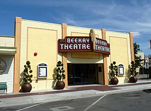
The Tehachapi Pops Orchestra (T-Pops) was founded in 2006. It plays a mix of popular music, jazz, and original songs. T-Pops performs five to six concerts every year. Most of these concerts are free to the public. They also have a special Halloween concert at the BeeKay Theater with the local theater group, the Tehachapi Community Theater Association.
As of 2010, the Tehachapi Community Theater Association group performs in the restored BeeKay Theater downtown.
City Government
Law Enforcement
The Tehachapi Police Department helps keep the city safe. The police department has changed its structure a few times throughout the city's history. It was first created when the city was founded, then later re-established in 1955, and again on November 27, 2006. As of 2024, the chief of police is Richard Standridge.
Local News
Newspapers
The city has a few local newspapers. These include the Tehachapi News, which has been published since 1899, and The Loop.
Getting Around Tehachapi
The Tehachapi Park and Ride facility is located at 335 W Tehachapi Boulevard. It offers free parking and connections to Kern Transit and Amtrak Thruway buses. Kern Transit Route 100 travels from Lancaster to Bakersfield. The Amtrak Thruway bus connects to Oxnard and Santa Barbara.
The Tehachapi Municipal Airport is about one mile east of the Park and Ride facility.
See also
 In Spanish: Tehachapi para niños
 | Kyle Baker |
 | Joseph Yoakum |
 | Laura Wheeler Waring |
 | Henry Ossawa Tanner |


