Tehachapi Pass facts for kids
Quick facts for kids Tehachapi Pass |
|
|---|---|

Tehachapi Pass
|
|
| Elevation | 3,771 ft (1,149 m) |
| Traversed by | Union Pacific Railroad Future California High-Speed Rail |
| Location | Kern County, California, US |
| Range | Tehachapi Mountains / Sierra Nevada |
| Coordinates | 35°06′08″N 118°16′58″W / 35.10222°N 118.28278°W |
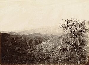
The Tehachapi Pass is a special pathway through the Tehachapi Mountains in Kern County, California. It's like a natural bridge connecting different parts of California. This pass is important because it links the San Joaquin Valley (a big farming area) with the Mojave Desert (a dry, sandy region).
For a long time, people have used this pass to travel. The Kitanemuk people, who are Native Americans, used it as a trade route many years ago. Later, in the 1800s, American settlers also started using it. Today, the pass is still a very busy route for both trains and cars.
Contents
A Path Through the Mountains
The Tehachapi Pass is located where the Tehachapi Mountains meet the Sierra Nevada mountain range. It's one of two main passes through the Tehachapi Mountains. The other one is Tejon Pass, which is at the other end of the range.
Trains and Roads
This pass has been important for transportation for over a century.
Historic Railroads
In 1876, a major train line called the Southern Pacific Railroad opened through the pass. Imagine how exciting it must have been to see trains traveling through the mountains! Today, these same tracks are owned by the Union Pacific Railroad. They are also used by the BNSF Railway, another big train company.
Modern Highways
In the 1930s, a road called U.S. Route 466 was built here. This road is now known as State Route 58. It's a busy highway that helps people travel between the valley and the desert.
Future High-Speed Rail
The Tehachapi Pass is also planned to be part of the new California High-Speed Rail line. This will be a super-fast train that connects cities like Palmdale and Bakersfield. It will make travel even quicker in the future!
Interesting Features
The area around Tehachapi Pass has some cool things to see and learn about.
Wind Farms
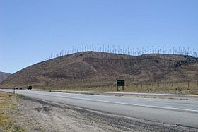
East and south of the pass, you can find the Tehachapi Pass Wind Farm. This is one of the biggest wind farms in California. It has many tall wind turbines that use the wind to create electricity. It's a great example of clean energy!
The Tehachapi Loop
About 18 miles (29 km) west of the highest point of the pass is a famous railroad landmark called the Tehachapi Loop. This is a special part of the train track where the railway actually loops over itself to gain elevation. It's an amazing piece of engineering and a popular spot for train enthusiasts to visit!
 | Delilah Pierce |
 | Gordon Parks |
 | Augusta Savage |
 | Charles Ethan Porter |


