
Tejon Pass facts for kids
Quick facts for kids Tejon Pass |
|
|---|---|
| Portezuelo de Cortes Portezuela de Castac |
|

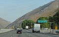
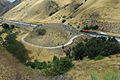
The top of the Tejon Pass on southbound Interstate 5 (2009)
|
|
| Elevation | 4,144 ft (1,263 m) |
| Traversed by | |
| Location | Los Angeles and Kern counties, California |
| Range | San Emigdio, Tehachapi, Sierra Pelona, and Topatopa Mountains |
| Coordinates | 34°48′10″N 118°52′36″W / 34.80278°N 118.87667°W |

Location in California
|
|
The Tejon Pass is a special mountain pass in California. It connects Southern California to the Central Valley. This pass is located between the Tehachapi Mountains and the San Emigdio Mountains.
Many people call the pass and the road leading north from it "the Grapevine." Over time, important roads have used this pass. These include the El Camino Viejo, the Stockton – Los Angeles Road, and now Interstate 5.
Contents
Exploring Tejon Pass Geography
Tejon Pass is a unique spot where two very large fault lines meet. These are the San Andreas Fault and the Garlock Fault. Faults are cracks in the Earth's crust where earthquakes can happen.
The highest part of the pass is in Los Angeles County. It is near a town called Gorman. The elevation here is about 4,160 feet (1,268 meters). This spot is about 70 miles (113 km) northwest of Los Angeles and 46 miles (74 km) south of Bakersfield.
Interstate 5 is a major highway that crosses the pass. It reaches its highest point in California here. This point is 4,144 feet (1,263 meters) high.
The pass rises slowly from the south, starting at Santa Clarita. But it drops very steeply on the north side. This steep part goes through Grapevine Canyon. It ends at Grapevine at about 1,499 feet (457 meters).
Near the northern slope of the pass is Fort Tejon State Historic Park. This park was once a U.S. Army post. It was first used by soldiers in 1854.
The Tejon Pass actually crosses four different mountain ranges. These are the Sierra Pelona, the Topatopa Mountains, the Tehachapis, and the San Emigdios.
History of Tejon Pass


Ancient Times at the Pass
The area around Gorman, California, has been a stopping place for a very long time. Before Europeans arrived, Native Americans used to stop here. It was a village called Kulshra'jek. This village was a trading center for thousands of years.
Early Explorers and Names
In 1772, a Spanish lieutenant named Pedro Fages crossed the pass. He was looking for soldiers who had left their posts. He named the pass Portezuelo de Cortes. He also named the canyon beyond it Cañada de las Uvas. This means "Canyon of the Grapes" because of all the wild grapevines there.
Later, a road called El Camino Viejo was used. This road connected Los Angeles to Mission Santa Clara de Asis. It crossed the pass and then went west.
The Original Tejon Pass
In 1806, a priest named Father Jose Maria Zalvidea explored the area. He named a different pass "Tejon" (which means "badger"). This was because they found a dead badger there. This original Tejon Pass is about 15 miles (24 km) northeast of the current Tejon Pass.
Before 1854, the main way to travel into the San Joaquin Valley was through this old Tejon Pass. This route was important for connecting the southern part of California to the northern goldfields.
Changes in the 19th Century
Castaic Pass and Fort Tejon Pass
In 1843, a ranch called Rancho Castac was created near the pass. At that time, the pass was called Portezuela de Castac.
After Fort Tejon was built in 1854, the pass became known as "Fort Tejon Pass." The old Tejon Pass route was not used as much anymore. Eventually, the Fort Tejon Pass became simply "Tejon Pass."
In 1858, the Butterfield Overland Mail stagecoach line used the pass. This line carried mail and passengers. It stopped at places like Gorman's, where horses were changed.
Modern Roads in the 20th Century

The Ridge Route was the first highway for cars through the pass. It connected the Central Valley with Los Angeles. This road was very winding. The northern part of it became part of U.S. Route 99. People called this part "The Grapevine."
The Ridge Route was improved over the years. In 1933, a three-lane highway replaced it. Then, a four-lane expressway was built in 1947. Finally, the eight-lane Interstate 5 freeway opened in 1970.

There was a dangerous part of the old highway called "Dead Man's Curve." Many accidents happened there. In 1932, a truck driver named Jack Klieby died there. He drove his truck off the road to avoid hitting other cars.
This dangerous curve was removed in 1935. The road was made straighter and safer. This new work made the road shorter and removed many sharp turns.
Wildlife in the Area
Wild bears live and roam in the rugged mountains around Tejon Pass.
Weather and Travel Impacts
The Tejon Pass is usually sunny in summer, spring, and autumn. However, in winter, it can have very bad weather. Sometimes, the pass has to close to traffic because of ice and snow.
Car engines can get very hot when driving up the long hill, especially in warm weather. The California Highway Patrol sometimes closes Interstate 5 between Grapevine and Castaic. This usually happens because of icy roads and the steepness of the pass. It is also a concern because many big trucks use this road. One accident in snowy conditions could stop all traffic. When the pass closes, drivers must wait or take a very long detour.
Communities Near Tejon Pass
The Tejon Pass has given its name to the Mountain Communities of the Tejon Pass. These communities start in the south at Santa Clarita. They include Castaic, Gorman, and Lebec. The pass ends at Grapevine.
The pass also goes by the Tejon Ranch. There are plans to build two large communities here. These are called Centennial and Tejon Mountain Village.
Images for kids
-
The top of the Tejon Pass on southbound Interstate 5 (2009)
-
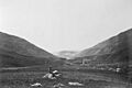
Tejon Pass near Grapevine, California, in 1868
-
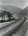
Interstate 5 through Tejon Pass, 1963
-
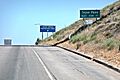
The exit to Fort Tejon, on the northward slope of the Tejon Pass just before descending into the Central Valley
-
A section of the 1915 Ridge Route in Lebec, California, known as "deadman's curve," was abandoned when the highway was improved over the Tejon Pass.
See also
 In Spanish: Puerto del Tejón para niños
