Keene, California facts for kids
Quick facts for kids
Keene
|
|
|---|---|

Location in Kern County and the state of California
|
|
| Country | |
| State | |
| County | Kern |
| Area | |
| • Total | 9.665 sq mi (25.034 km2) |
| • Land | 9.660 sq mi (25.020 km2) |
| • Water | 0.005 sq mi (0.014 km2) 0.056% |
| Elevation | 2,602 ft (793 m) |
| Population
(2020)
|
|
| • Total | 469 |
| • Density | 48.53/sq mi (18.735/km2) |
| Time zone | UTC-8 (PST) |
| • Summer (DST) | UTC-7 (PDT) |
| ZIP code |
93531
|
| Area code(s) | 661 |
| FIPS code | 06-37946 |
| GNIS feature ID | 1660828 |
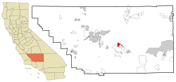
Keene (once called Wells) is a small community in Kern County, California. It sits in the foothills of the Tehachapi Mountains. This area is at the southern edge of the San Joaquin Valley.
Keene is about 8.5 miles (13.7 km) northwest of Tehachapi. It is located at an elevation of 2,602 feet (793 meters) above sea level. In 2020, about 469 people lived there. This was a small increase from 431 people in 2010.
Keene is also home to the main office of the United Farm Workers (UFW). This is a national group for farmworkers. It was started and led by Cesar Chavez. The UFW headquarters is sometimes called "Nuestra Señora Reina de La Paz," which means "Our Lady Queen of Peace."
Contents
Geography of Keene
Keene is located at coordinates 35°13′25″N 118°33′44″W. This small community covers an area of about 9.7 square miles (25.0 square kilometers). Almost all of this area is land.
A tiny community called Woodford used to exist about 1 mile southeast of Keene. It had about 30 buildings.
Keene's Climate
Keene has a climate where temperatures can get quite low in winter. It is in a plant hardiness zone called 8b. This means winter temperatures can drop to between 15 and 20 degrees Fahrenheit (–9 to –7 degrees Celsius).
| Climate data for Keene, CA (2,602 feet above sea level) | |||||||||||||
|---|---|---|---|---|---|---|---|---|---|---|---|---|---|
| Month | Jan | Feb | Mar | Apr | May | Jun | Jul | Aug | Sep | Oct | Nov | Dec | Year |
| Record high °F (°C) | 79.0 (26.1) |
90.0 (32.2) |
89.0 (31.7) |
94.0 (34.4) |
104.0 (40.0) |
112.0 (44.4) |
111.0 (43.9) |
110.0 (43.3) |
107.0 (41.7) |
100.0 (37.8) |
86.0 (30.0) |
79.0 (26.1) |
112.0 (44.4) |
| Mean daily maximum °F (°C) | 57.0 (13.9) |
60.0 (15.6) |
66.0 (18.9) |
71.0 (21.7) |
81.0 (27.2) |
90.0 (32.2) |
97.0 (36.1) |
96.0 (35.6) |
88.0 (31.1) |
78.0 (25.6) |
65.0 (18.3) |
56.0 (13.3) |
75.4 (24.1) |
| Daily mean °F (°C) | 45.5 (7.5) |
48.5 (9.2) |
53.5 (11.9) |
58.5 (14.7) |
68.5 (20.3) |
77.0 (25.0) |
83.5 (28.6) |
82.0 (27.8) |
74.5 (23.6) |
64.0 (17.8) |
52.5 (11.4) |
44.5 (6.9) |
62.7 (17.1) |
| Mean daily minimum °F (°C) | 34.0 (1.1) |
37.0 (2.8) |
41.0 (5.0) |
46.0 (7.8) |
56.0 (13.3) |
64.0 (17.8) |
70.0 (21.1) |
68.0 (20.0) |
61.0 (16.1) |
50.0 (10.0) |
40.0 (4.4) |
33.0 (0.6) |
50.0 (10.0) |
| Record low °F (°C) | 11.0 (−11.7) |
16.0 (−8.9) |
−5.0 (−20.6) |
27.0 (−2.8) |
34.0 (1.1) |
38.0 (3.3) |
43.0 (6.1) |
48.0 (8.9) |
38.0 (3.3) |
22.0 (−5.6) |
13.0 (−10.6) |
8.0 (−13.3) |
−5.0 (−20.6) |
| Average precipitation inches (mm) | 1.20 (30) |
1.58 (40) |
0.97 (25) |
0.23 (5.8) |
0.10 (2.5) |
0.04 (1.0) |
0.32 (8.1) |
0.28 (7.1) |
0.14 (3.6) |
0.37 (9.4) |
0.60 (15) |
0.89 (23) |
6.72 (170.5) |
| Source: Weather Channel | |||||||||||||
History of Keene
Keene was founded in 1876. It was first named Wells, after a local rancher named Madison P. Wells. The town was a railroad stop. In 1879, a post office opened, but it closed in 1881. It reopened in 1885. Later, the town was renamed Keene to honor a financier named James P. Keene.
Cesar Chavez and the United Farm Workers
The United Farm Workers (UFW) moved its main office to Keene from Delano, California. César Chávez, a famous civil rights leader, spent his last years living in Keene. His office at the UFW was filled with many books. These books covered topics like philosophy, economics, and biographies of leaders like Mahatma Gandhi and the Kennedy family.
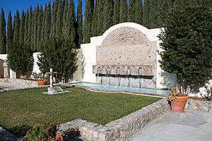
Cesar Chavez is buried in Keene, on the grounds of the UFW headquarters. You can find his gravesite at 29700 Woodford Tehachapi Rd, Keene, CA 93531.
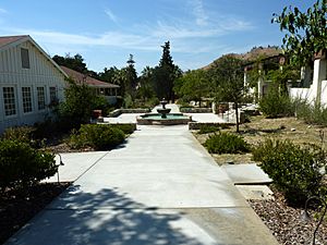
The National Chavez Center opened on the UFW campus in 2004. It was created by the Cesar E. Chavez Foundation. Today, it has a visitor center, a memorial garden, and Chavez's gravesite. In the future, the 187-acre (0.76 km²) site will also have a museum and a conference center. These will help people learn more about Chavez's important work.
A special part of the site, covering two acres, was named the César E. Chávez National Monument on October 8, 2012. This makes it a protected historical place.
Population of Keene
In 2010, Keene had a population of 431 people. By 2020, the population had grown slightly to 469 people. The community is made up of people from various backgrounds.
See also
 In Spanish: Keene (California) para niños
 | Claudette Colvin |
 | Myrlie Evers-Williams |
 | Alberta Odell Jones |


