Canebrake, California facts for kids
Quick facts for kids
Canebrake
|
|
|---|---|

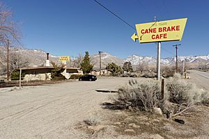
Canebrake Cafe, possibly the only commercial establishment in Canebrake
|
|
| Country | United States |
| State | California |
| County | Kern County |
| Elevation | 3,031 ft (924 m) |
Canebrake is a small, unincorporated community. It is found in Kern County, California. The community is located along California State Route 178. It sits in the South Fork Valley. Canebrake is about 5.3 miles (8.5 km) east-northeast of Onyx. It is at an elevation of 3,031 feet (924 meters).
Contents
Discovering Canebrake
Canebrake is a quiet place in California. It is known for its natural beauty. The area is part of the Sierra Nevada mountains. It offers a glimpse into California's past.
Where is Canebrake Located?
Canebrake is in the eastern part of Kern County. It is nestled in a valley. The community is easy to reach by California State Route 178. This road follows Canebrake Creek. The creek flows down from Walker Pass.
The Story Behind the Name
Canebrake Creek was named in 1853. Robert S. Williamson named it. He was exploring the area. He saw Native Americans collecting sugary reeds. These reeds came from a "canebrake," or bulrush patch. This is how the creek, and later the community, got its name.
Canebrake Creek is important for the local environment. It is a major stream. It flows into the South Fork Kern River. This river is part of the Canebrake Ecological Reserve. This reserve helps protect local wildlife.
Exploring the Area Around Canebrake
The original town site of Canebrake was a bit different. It was located about three miles further east. This was along the Isabella-Walker Pass Road.
Today, Canebrake is a gateway to adventure. The Chimney Peak Back Country Byway starts here. This scenic road leads to the Chimney Peak Wilderness. It connects to some very wild and remote parts. These areas are in the Southern Sierra Nevada mountains. They are great for exploring nature.
 | James Van Der Zee |
 | Alma Thomas |
 | Ellis Wilson |
 | Margaret Taylor-Burroughs |


