Edward Kern facts for kids
Quick facts for kids
Edward Kern
|
|
|---|---|
| Born | October 26, 1822 or October 26, 1823 |
| Died | (aged 40–41) Philadelphia, Pennsylvania, US
|
| Burial place | New Glenwood Cemetery, Broomall, Philadelphia |
| Nationality | American |
| Other names | Ned |
| Occupation | Explorer, artist, cartographer, topographer, and United States Army officer |
| Known for | Exploring, documenting and imaging the American West |
| Military career | |
| Allegiance | Union |
| Service/ |
Union Army in California |
| Rank | Lieutenant in the California Battalion |
| Commands held | Commanded the garrison at Sutter's Fort |
Edward Meyer Kern (born October 26, 1822 or 1823 – died November 25, 1863) was an American artist, mapmaker, and explorer. He explored parts of California, the Southwestern United States, and East Asia. The famous Kern River and Kern County, California are named after him.
Contents
Edward Kern: Explorer and Artist
Edward Kern was a talented artist and explorer. He helped map new areas and drew pictures of what he saw. His work helped people back home understand the American West.
Early Life and Family
Edward Kern was born in Philadelphia, Pennsylvania. His father was John Kern III and his mother was Mary Elizabeth Bignell. Edward learned to be an artist.
He had two brothers who were also very talented. Richard Kern (1821–1853) was a skilled artist. Benjamin Kern (1818–1849) was a doctor. All three brothers joined Edward on some of his exciting journeys.
Exciting Expeditions
Edward Kern went on many important expeditions. He helped explore and map new territories. He also drew pictures of the landscapes and people he met.
Exploring California
In 1845–46, Kern joined Captain John C. Frémont on his third expedition. They traveled into Mexican Alta California. Kern earned $3.00 a day for his work.
He was a cartographer, meaning he made maps. He also drew pictures of plants and animals they found. Every night, Kern drew a map of their day's journey. He also sketched important landmarks.
Near Klamath Lake, the expedition faced conflict with Klamath tribesmen. Frémont's group responded, and Kern recorded the event in an engraving. This drawing was later published in Frémont's report.
Frémont sent Kern and Joseph Walker on a southern route through the Sierra Nevada mountains. Frémont named the pass they used Walker Pass. Kern mapped the Kern River, which was then called the Rio de San Felipe. Frémont later named the river after Edward Kern.
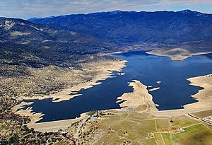
Kern's old campsite is now under Lake Isabella. A historical marker for his site is near the lake on Highway 178.
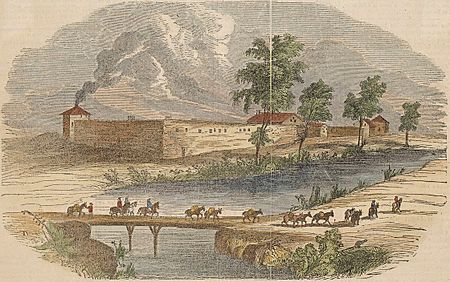
During the 1846 Bear Flag Revolt against Mexico, Frémont put 23-year-old Kern in charge of Sutter's Fort. This fort was in the Sacramento Valley. John Sutter, the fort's owner, became Kern's second-in-command.
While at the fort, Kern heard about the Donner Party being stranded in the mountains. Sutter's Fort was their destination. Kern tried to help organize a rescue. He was later criticized for delays in the search.
In 1847, Kern's forces joined with John Sutter to address conflicts with California Indians. They were involved in attacks that became known as the Kern and Sutter actions.
Adventures in the Southwest
In 1848−1849, Edward and his brothers Richard and Benjamin joined Frémont's fourth expedition. They explored the Rocky Mountains in what is now southern Colorado and northern New Mexico. The journey was very difficult.
Benjamin Kern and the guide Old Bill Williams were later killed by a band of Utes while trying to retrieve hidden supplies.
In 1849, Edward and Richard Kern joined a military expedition. This trip was to the Navajo people in New Mexico. It aimed to make a treaty and survey the land. Richard drew portraits of Native American chiefs and landscapes. Edward was the main mapmaker.
The Kern brothers stayed in New Mexico for two years. They worked for the Corps of Topographical Engineers. Their drawings gave Americans some of the first true images of Arizona, New Mexico, and southern Colorado. These included views of Canyon de Chelly, Chaco Canyon, and El Morro.
In 1853, Edward joined Lieutenant John Pope. They looked for a better route between Santa Fe and Fort Leavenworth. Sadly, his brother Richard was killed that same year. Richard was on another expedition surveying a railroad route.
Journeys to Asia
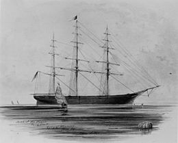
From 1853 to 1855, Edward Kern sailed on the ship USS Vincennes. This was an expedition to East Asia. Kern used both photography and drawing on this trip. He spent several weeks on the eastern shores of Siberia. The expedition returned home through Tahiti and San Francisco.
In 1858, Kern joined Lieutenant John Mercer Brooke. They surveyed sea routes between California and China. He returned in 1860.
Civil War Service
During the American Civil War, Kern served under Frémont. Frémont commanded the Army of the West. When Frémont was removed from command, Kern was also relieved of his duties.
Later Life and Legacy
Edward Kern had epilepsy from a young age. Later in his life, he opened an art studio in Philadelphia. He passed away in November 1863 from an epileptic seizure at his home. He was buried in Glenwood Cemetery.
Kern's old diaries were found hidden in an old hotel. These diaries provided important information for a book about his brother, Richard Kern. His diaries and papers are now kept at Yale University.
The Boston Museum of Fine Arts has over eighty of Kern's artworks. The Kern River and Kern County, California, are both named in his honor.
California Historical Landmark
| Edward Kern Campsite | |
|---|---|

Aerial of Lake Isabella site of Edward Kern Campsite
|
|
| Location | Entrance to Old IsabelIa Rd Recreation Area, Lake Isabella, California |
| Official name: Edward Kern Campsite | |
| Designated | July 5, 1960 |
| Reference no. | 742 |
At the entrance to Old Isabella Road Recreation Area, near Lake Isabella, there is a marker. This marker is called Edward Kern Campsite. It notes the campsite of Captain John C. Frémont's third expedition with Edward M. Kern. The recreation area is on California State Route 178 on the south side of the lake.
The California Historical Landmark reads:
- NO. 742 CAMPSITE OF EDWARD M. KERN - Near this spot at the confluence of the north and south forks of the Kern River, the Theodore Talbot party of Captain John C. Frémont's third expedition to the West camped for several weeks during December 1845 and January 1846. Frémont named the river in honor of Edward M. Kern, topographer for the expedition - Kern County was established in 1866.
See also
 | Janet Taylor Pickett |
 | Synthia Saint James |
 | Howardena Pindell |
 | Faith Ringgold |


